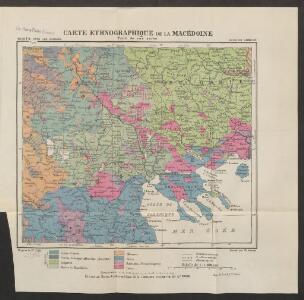
Maps of Macedonia

Carte ethnographique de la Macédoine, Point de vue serbe
Makedonien Ethnische Gruppe Th. Weinreb del.
Carte ethnographique de la Macédoine, Point de vue bulgare
Makedonien Ethnische Gruppe Th. Weinreb del.
Der von der IMRO geplante Mazedonische Staat
Makedonien Innere Makedonische Revolutionäre Organisation
Národopisná mapka Macedonie
Makedonie Král z Dobré Vody, Vojtěch Kančov, Vasil
Etnografska karta na Makedonija
Makedonien Ethnische Gruppe
Internationale und nationale Grenzen in der Provinz Makedonien seit 1944
Makedonien Grenzen
[Mazedonien]
Makedonien
Izvod ot etnografskata karta na Ležana
Makedonien Ethnische Gruppe
Izvod ot etnografskata karta na Mekenzi i Erbi
Makedonien Ethnische Gruppe
Mazedonien
1 : 3000000 Makedonien (Landschaft) Weltkrieg <1914-1918>
[Bălgarska zemja v Makedonija]
Makedonien Ethnische Gruppe Bulgaren
[Mazedonien]
Makedonien
Carte de la Macédoine d'une partie de l'Albanie, de l'Epire et de la Thessalie
1 : 800000 Albánie Lapie, Pierre Kaeppelin Société geologique de France
Karte von dem Alten Macedonien Thessalien und Epirus
Epirus (Řecko) Baumgarten, Siegmund Jakob Johann Justinus Gebauer
H.8. Skoplje, uit: [Übersichtskarte von Europa 1:750.000]
1 : 750000 Wien : K.u.K. Militärgeographisches Institut
Demarkationslinie vor Beginn der Kriege gegen die Bulgaren
Südosteuropa Balkankrieg <1912-1913> Grenze
Saloniki und die Halbinsel Chalkidike
1 : 1250000 Chalkidiki (Řecko) Freytag & Berndt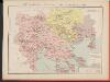
Carte des écoles et églises du vilayet de Salonique (1908)
Griechenland Selanik
[Macedonien]
1 Karte : Kupferdruck ; 18 x 13 cm [Trattner]
Carte des écoles et églises du vilayet de Monastir (1908)
Makedonien Vilâyet Manastır Osmanisches Reich Kirchenbau Schulgebäude Kümmerly & Frey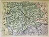
Süd-Serbien
1 : 800000 Serbien (Süd)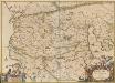
Macedonia Alexandri M. Patria Illustris. [Karte], in: Novus atlas absolutissimus, Bd. 10, S. 67.
1 Karte aus Atlas Janssonius Offizin
Ligne de partage d'après la carte annexée au traité d'alliance
Balkanhalbinsel Grenze Balkankrieg <1912-1913> Annexion
Ligne de partage d'après la carte annexée au Traité d'Alliance
Bulgarien Serbien Balkankrieg <1912-1913> Territorialer Anspruch Th. Weinreb del.
Karte der Flußgebiete des Drin und des Wardar
1 : 500000 Vardar-Gebiet Flusssystem Hahn, Johann Georg von
Saloniki, Seres, Xanthi, Kastro, Pharsalos
1 : 750000 Fársala (Řecko) Budik, A. K. u. k. Militärgeographisches Institut
Salonik, Seres, Xanthi, Kastro, Phersala
1 : 750000 Soluň (Řecko) K. k. militär-geographisches Institut
Elbasan, Argyrokastron, Joannina, Corfu, Philiataes
1 : 750000 Korfu (Řecko : ostrov) Nimmerfroh, J. K. u. k. Militärgeographisches Institut
Elbasan, Argyrokastron, Janina, Korfu, Philiataes
1 : 750000 Korfu, ostrov (Řecko) Nimmerfroh, J. Wohlstein, K. K. u. k. Militärgeographisches Institut