Maps of Malay Archipelago

Charte von Ostindien jenseits des Ganges
Zadní Indie
CHARTE von OSTINDIEN Jenseits des Ganges
Ganga-oblast (Indie a Bangladéš)
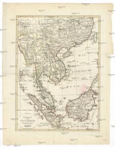
Eastern Islands, Birmah &c.
1 : 15200000 Hughes, William
La presqu'isle de l'Indie au dela du Gange, avec l'archipel des Indes
1 : 12640000 Asie jihovýchodní Bonne, Rigobert André
Malesia ossia Arcipelago Indiano, ed India-Transgangetica.
1 : 11300000 Marzolla, Benedetto
Hinterindien nebst den Hinterindischen Inseln
1 : 10000000 entworfen und gezeichnet im Jahre 1826 von C. F. Weiland, nach Crawfurd, Kolf und Krusenstern umgearb. und berichtigt 1832, und im Jahre 1838, abermals nach Raffles und Berghaus' Atlas von Asien theilweis umgearb. und berichtigt Weimar : Verlag des Geograph. Instituts
Hinterindien die Philippinen, Molukken und Sunda Inseln
Schul-Atlas in 36 Karten Völter, Daniel Verlag der J.M. Dannheimer'schen Buchhandlung
Ostindische Inseln
Adolf Stieler's Handatlas über alle Theile der Erde und über das Weltgebäude Stieler, Adolf Justus Perthes
Ostindische Inseln
1 : 12500000 Filipíny Berghaus, Herm. Eberhardt, H. Justus Perthes
Kaart van den Oost-Indischen Archipel
[Java und Madoera, geologische Detailkarten und Profile] Verbeek, R. D. M. Joh. C. Stemler Cz.
East India Islands.
1 : 21500000 Arrowsmith, Aaron
East India Islands.
1 : 21500000 Arrowsmith, Aaron
Niederländisch-Indien
1 : 13000000 Druck und Verlag von Carl Flemming. Glogau : Carl Flemming
Niederländisch-Indien / Druck und Verlag von Carl Flemming
Glogau : Carl Flemming
East India Islands.
1 : 13500000 Bowen, Emanuel
Hinterindien und Malaien-Archipel
1 : 18000000 Malajsie Meyer, Joseph Bibliographisches Institut
East Indies.
1 : 12000000 Colton, G.W.
Archipel Asiatique.
1 : 10000000 Vivien St Martin, L.
East Indies.
1 : 12672000 Colton, G.W.
East Indies.
1 : 11000000 Colton, G.W.
East India Isles.
1 : 8700000 Cary, John, ca. 1754-1835
China, Indo-China, Malaysia.
1 : 9500000 Rand McNally and Company
China.
1 : 9500000 Rand McNally and Company
East Indies.
1 : 12000000 Colton, G.W.
East Indies.
1 : 11000000 Colton, G.W.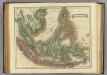
E. India Islands.
1 : 9000000 Lizars, Daniel
Die Ostindischen Inseln
[S.l. : s.n.]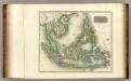
East India Isles.
1 : 8800000 Thomson, John
地圖綜要 : 三卷(東南海濱諸夷國圖)
地圖綜要 南明弘光元年(1645),吴学俨等编纂,李釜源鉴定,朗润堂藏板。 该书为明末军事防务地图集,涉及诸多江防、海防、边防等相关地图和解说,军事意味明显,这与成书背景有密切关系。该书在江南刊刻成书之际,清军已大举入关,大明王朝覆灭,仅剩南明小王朝残喘于南方,军事防务至关重要。也因其明显的南明立场,该书被列为四库禁毁书。全书分总卷、内卷和外卷三部分。燕京藏本共八册,书前序言、凡例和目录的总卷部分缺失。 总卷论及大明疆域沿革、军事防守要害、各省道里等内容,地图有《華夷古今形勝圖》,未画方,标绘各府所在,在空白处标注史地简介;《天下各鎮各邊要圖》,未画方,标注北方边防各山口关隘、东南海防、西南边防等;《京省合宿分界圖》,未画方,图上方标注各星宿,对应大明各府州;《天下輿地分里總圖》,计里画方,每方五百里,绘制两京十三省各府所在地。 内卷为两京十三省的建置总数、分里图、分界图、各府州县志、总论及事宜,其中,建制总数包括府州县卫所及各类机构数量、户数、口数、税、钞、丝、绢、盐、马草等数量;分里图采用计里画方,分别绘制两京十三省各府、州、县、卫所及山川河流名;分界图则以突出府界和州县的相对位置,并不追求里程的准确性,因此,与分里图相比,不仅删去了山川地名和解说,而且地图变形较大,以便于较为疏朗地标注各府州县地名;各府州县志则包括省内各府的山川河流、土产古迹、名宦人物等通常为方志所记载的内容;总论高度概括各地历史和地理形势;事宜则多论及该地的军事守备要领。每省分里图和分界图各一幅。 外卷主要为江防、海防、边防相关地图和图说。包括《長江會源分里全圖》《江防全圖》《漕河分里圖》《黃河分里圖》《海防全圖》《日本島夷入寇要害圖》《海運分里圖》《九邊總圖》及九边分图《遼東沿邊圖》《薊鎮沿邊圖》《宣府沿邊圖》《大同沿邊圖》《山西沿邊圖》《大同山西二邊分里合圖》《延綏沿邊圖》《寧夏沿邊圖》《固原沿邊圖》《甘肅沿邊圖》《四夷總圖》及四夷分图《東北諸夷圖》《朝鮮圖》《日本圖》《琉球圖》《東南海夷圖》《東南濱海諸夷圖》《西南海夷圖》《安南圖》《迤北西番諸夷圖》《西域圖》《朔漠圖》等。 在外卷诸图中,以《江防全圖》规模最大、绘制最为详细,并附有详细的解说,显然,这与当时南明小王朝偏居南方的局势密切相关,天堑长江实际上已经成为南明小王朝最后的屏障。 在图例上,府用正方形,州用菱形(包括土州),县用椭圆,卫所用椭圆外加四方短线,但图上大多数卫所并没有标志。 李釜源名茹春,崇祯十年(1637 年)进士,知华亭县。 《中國古籍善本書目》著录。 8册64图,墨刻本,中文,尺寸24.7 x 16.3 cm,计里画方。 Harvard-Yenching | Rare Book | T 3080.7 2925,Harvard-Yenching | Microfilm | FC9113, Master Microforms | Offsite Storage | Film Mas 34483;Hollis Number:008094513 吴学俨等 朗润堂