Maps of Bern
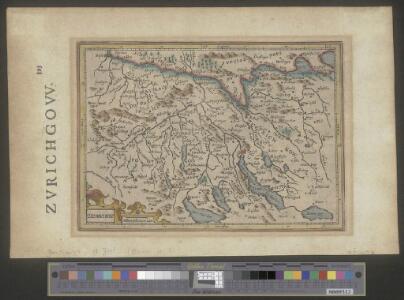
Zurichou
1 : 653000 1 Karte [Jodocus Hondius] [Printed by T. Cotes], [London]
Eisenbahnprojecte der Central- und Ost-Schweiz
1 : 250000 1 Karte zusammengestellt vom zürch. Ingenieurs-Verein [Verlag nicht ermittelbar], [Erscheinungsort nicht ermittelbar]
[Reisekarte der Schweiz]
1 : 500000 1 Karte auf 6 Bl. gezeichnet v. H. Keller ; gest. v. J.J. Scheurmann [Füssli & Comp.], [Zürich]
Pagi et Exstantiores quidam Comitatus Veteris Alamanniae et Burgundiae Transiuranae qui Augustae Genti Habsburgicae vel universi parebant vel in quibus Gens illa Ius suum Exercebat.
1 : 340000 Mollova mapová sbírka Weis, Franz J. Kaliwoda, Leopold Johann
Projektierte Eisenbahnen der Zental- und Ostschweiz; Übersichtskarte
1 : 250000 Mit Legende. Zusammenstellung: Zürcher Ingenieurs-Verein Eidgenössisches Stabsbüro
Zurichgow et Basiliensis provincia
1 : 340000 1 Karte [Hondius oder Janssonius], [Amsterdam]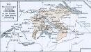
Das allmälige Wachsthum des österreichischen Staates. No. 45 Die Besitzungen des Hauses Habsburg in der Schweiz in ihrer grösten Ausdehnung
Schweiz Habsburger, Familie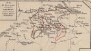
Die Besitzungen des Hauses Habsburg in der Schweiz in ihrer grössten Ausdehnung
Schweiz Habsburger, Familie
[Zurichgow, et Basiliensis provincia]
1 : 250000 1 Karte per Gerardum Mercatorem [sumptibus & typis aeneis Iudoci Hondij], [Amsterodami]
Zurichgow
1 : 1000000 1 Karte [sumptibus et typis aenis Iudoci Hondij], [Amsterodami]
Uebersichtskarte der Schweiz. Nordostbahn
1 : 400000 1 Karte Topogr. Anstalt Winterthur, J. Schlumpf, vorm. Wurster Randegger u. Co., Winterthur
Zurichgow et Basiliensis provincia
1 : 340000 1 Karte [sumptibus & typis aeneis Henrici Hondij], [Amsterodami]
[Zurichgow, et Basiliensis provincia]
1 : 250000 1 Karte per Gerardum Mercatorem [Mercator], [Duisburg]
Regenkarte der Nordostschweiz vom 3. Juni 1878
1 : 1000000 1 Karte Frey, Zürich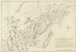
Mappa Situationem Fontium Danubii Aliorumq. Principaliorum Europae Fluminum Geographicè repraesentans: Quam Profila huc spectantia, cognitis per Barometrum Altitudinibus, Mathematicè ad oculum demonstrant
1 : 500000 Mollova mapová sbírka Marsili, Luigi Ferdinando
Eisenbahnprojecte der Central- und Ost-Schweiz
1 : 250000 Zürcher Ingenieur- und Architektenverein [s.n.]
<<Der>> Bund der III Waldstätte sammt dem grösseren Theile des Aar-, Thur- und Zürich-Gaues
1 : 925000 1 Karte [bearb. nach Urkunden und den vorzüglichsten Werken Schweizerischer Geschichte von E. Scheuermann] [Scheuermann], [Aarau]
[Zurichgow, et Basiliensis provincia]
1 : 250000 1 Karte per Gerardum Mercatorem [Mercator], [Duisburg]
Original von Keller's zweiter Reisekarte der Schweiz
1 : 500000 1 Karte in 4 Teilen gest. v. J. Scheurmann Keller, Zürich
[Zurichgow, et Basiliensis provincia]
1 : 250000 1 Karte per Gerardum Mercatorem [Hondius], [Amsterdam]
Zurichou [i.e. Zürichgau]
1 : 600000 1 Karte [von Joannes Janssonius] [ex officina Ioannis Ianssonii], [Amsterodami]
Vollständige Carte des gantzen Rhein Stroms]
1 : 840000 Mollova mapová sbírka Riegel, Christoph Riegel, Christoph
Nova Helvetiae Tabula Geographica
1 : 380000 Mollova mapová sbírka Scheuchzer, Johann Jakob Schenk, Peter II
[Zurichgow, et Basiliensis provincia]
1 : 250000 1 Karte per Gerardum Mercatorem [sumptibus & typis aeneis Iudoci Hondij], [Amsterodami]
<<Le>> canton de Zurich
1 : 600000 1 Karte
Niederschlagsmengen der Nordschweiz im Jahre 1891
1 : 1300000 1 Karte Schlumpf, Winterthur
[Zurichgow, et Basiliensis provincia]
1 : 250000 1 Karte per Gerardum Mercatorem [Mercator], [Duisburg]
Zurichgow et Basiliensis provincia
1 : 300000 1 Karte [apud Iohannem et Cornelium Blaeu], [Amsterdam]
Zurichou [i.e. Zürichgau]
1 : 650000 1 Karte [von Jodocus Hondius] [excusum in aedibus Iudoci Hondij], [Amsterodami]