Maps of Switzerland

Regenkarte der Nordostschweiz vom 3. Juni 1878
1 : 1000000 1 Karte Frey, Zürich
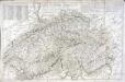
[De situ confoederatorum descriptio]
1 : 950000 1 Karte [Konrad Türst] [Verlag nicht ermittelbar], [Erscheinungsort nicht ermittelbar]
Helvetiæ Rhetiæ [et] Valesiæ cum omnibus finitimis regionibus tabula vulgo Schweitzerland
1 Karte : Kupferdruck ; 40 x 51 cm Janssonius apud Joannem Janssonium
Helvetiae Rhetiae & Valesiae cum omnibus finitimis regionibus Tabula Vulgo Schweitzerland
1 : 790000 Mollova mapová sbírka Janssonius, Johannes I
<<Die>> VIII alten Orte im Frieden von 1389
1 : 1300000 1 Karte [bearb. nach Urkunden und den vorzüglichsten Werken Schweizerischer Geschichte von E. Scheuermann] [Scheuermann], [Aarau]
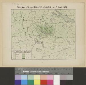
Niederschlagsmengen der Nordschweiz im Jahre 1891
1 : 1300000 1 Karte Schlumpf, Winterthur
<<Die>> VIII alten Orte im Frieden von 1412
1 : 1300000 1 Karte [bearb. nach Urkunden und den vorzüglichsten Werken Schweizerischer Geschichte von E. Scheuermann] [Scheuermann], [Aarau]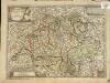
Helvetiae Rhætiæ et Valesiæ nova tabula geographica
1 Karte : Kupferdruck ; 27 x 38 cm Steiner s.n.
La Suisse qui comprend: les XIII cantons, leurs sujets et leurs allié[s]
1 Karte : Kupferdruck ; 48 x 64 cm Daudet; Joubert chéz v.e Daudet Etiennette Leblon et Joubert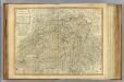
Switzerland.
1 : 540000 Robert Laurie & James Whittle
Helvetiorum reipublicæ cantones XIII; ut et fæderata Rhætia
1 Karte : Kupferdruck ; 48 x 57 cm Valck Gerard Valck
<<Die>> Eydtgnoschafft oder das Schweitzerland mit den anstossenden Ländern
1 : 750000 1 Karte [Sebastian Münster] [Henricpetri], [Basel]
Die Eÿdtgnoschafft Pünten vnd Wallis
1 Karte : Kupferdruck ; 27 x 35 cm Gyger Merian
Novissima et accuratissima Helvetiae, Rhaetiae, Valesiae, et partis Sabaudiae tabula
1 : 590000 Raetie Lotter, Tobias Conrad apud Tobiam Conr. Lotter
Novissima et accuratissima Helvetiae, Rhaetiae, Valesiae, et partis Sabaudiae tabula
1 : 590000 Raetie Lotter, Tobias Conrad apud Tobiam Conr. Lotter
Novissima et accuratissima Helvetiae, Rhaetiae, Valesiae et partis Sabaudiae tabula
1 : 600000 Raetie Lotter, Tobias Conrad apud Tobiam Conr. Lotter
Novissima et accuratissima Helvetiae, Rhaetiae, Valesiae, et partis Sabaudiae tabula
1 : 590000 Raetie Lotter, Tobias Conrad apud Tobiam Conr. Lotter
Novissima et accuratissima Helvetiae, Rhaetiae, Valesiae et partis Sabaudiae tabula
1 : 600000 Raetie Lotter, Tobias Conrad apud Tobiam Conr. Lotter
Carte de Suisse ou sont les treize cantons leurs alliés et leurs sujets
1 Karte : Kupferdruck ; 50 x 66 cm Rouvier; Rocque; Kitchin; Bowles printed for Carington Bowles at no. 69 in St. Pauls church y.d
Dr. Konrad Türsts Karte der Eidgenossenschaft 1495/1497
1 : 500000 1 Karte Lith. Anst. J. Tribelhorn, St. Gallen
Tabula nova heremi Helvetiorum
1 : 400000 1 Karte [hrsg. von Martin Waldseemüller?] [Schott], [Strassburg]
Nova Totius Helvetiae cum suis Subditis ac Sociis Tab. Geogr.
1 : 1200000 Mollova mapová sbírka Seutter, Matthäus Seutter, Matthäus
Exactißima Helvetiae Rhaetiae, Valesiae Caeterorumque Confoederatorum ut et finitimorum Populorum Regionum Tabula
1 : 760000 Mollova mapová sbírka Hogeboom, Andries Schenk, Peter II
Exactißima Helvetiae Rhaetiae, Valesiae Caeterorumq; Confoederatorum ut et finitimorum Populorum Regionum Tabula
1 : 800000 Mollova mapová sbírka Visscher, Nicolaes Homann, Johann Baptist Funck, David
Switzerland.
1 : 923000 Johnson, A.J.
Switzerland.
1 : 835000 Sharpe, J.
Switzerland.
1 : 1000000 Colton, G.W.
<<La>> Suisse divisée en ses cantons, ses alliés et sujets et distinguée en pays catholiques, protestans et mixtes
1 : 1250000 1 Karte par [Louis] Brion chez Desnos, Rue St-Jacques au Globe, Paris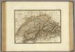
Suisse.
1 : 745000 Brue, Adrien Hubert, 1786-1832