Maps of Switzerland

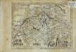
Niederschlagsmengen der Nordschweiz im Jahre 1891
1 : 1300000 1 Karte Schlumpf, Winterthur
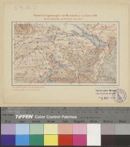
Regenkarte der Nordostschweiz vom 3. Juni 1878
1 : 1000000 1 Karte Frey, Zürich
[De situ confoederatorum descriptio]
1 : 950000 1 Karte [Konrad Türst] [Verlag nicht ermittelbar], [Erscheinungsort nicht ermittelbar]
<<Die>> Eydtgnoschafft oder das Schweitzerland mit den anstossenden Ländern
1 : 750000 1 Karte [Sebastian Münster] [Henricpetri], [Basel]
Karte des Kriegs-Schauplatzes der Schweiz
1 : 700000 2 Karten Verlag der Steiner'schen Buchhandlung, [Winterthur]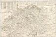
Nouvelle carte hydrographique et routiere de la Suisse
1 : 440000 Švýcarsko Weiss, Johann Heinrich J.H. Weiss
Neue Karte von der Schweiz oder Helvetien in die XIII Eidgenossenschaften, ihre Bundsverwandten und Unterthanen eingetheilt
1 Karte in 2 Bl nach den zuverlässigsten Nachrichten und neuesten astronomischen Beobachtungen, London 1778 bei W. Faden [, neu hrsg. von F.A. Schraembl] Schalbacher, Wien
<<Die>> VIII alten Orte im Frieden von 1412
1 : 1300000 1 Karte [bearb. nach Urkunden und den vorzüglichsten Werken Schweizerischer Geschichte von E. Scheuermann] [Scheuermann], [Aarau]
Innsbruck, Trient, Basel, Zürich
1 : 750000 Basilej (Švýcarsko : oblast) Hübl, E. K. u. k. Militärgeographisches Institut
Innsbruck, Trient, Basel, Zürich
1 : 750000 Basilej (Švýcarsko : oblast) K. k. militär-geographisches Institut
<<Die>> VIII alten Orte im Frieden von 1389
1 : 1300000 1 Karte [bearb. nach Urkunden und den vorzüglichsten Werken Schweizerischer Geschichte von E. Scheuermann] [Scheuermann], [Aarau]
Tabula nova heremi Helvetiorum
1 : 400000 1 Karte [hrsg. von Martin Waldseemüller?] [Schott], [Strassburg]
La Suisse qui comprend: les XIII cantons, leurs sujets et leurs allié[s]
1 Karte : Kupferdruck ; 48 x 64 cm Daudet; Joubert chéz v.e Daudet Etiennette Leblon et Joubert
Archäologische Karte der Ostschweiz
1 : 380000 1 Karte von Ferdinand Keller J. Wurster & Co., Zürich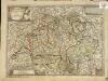
Helvetiae Rhætiæ et Valesiæ nova tabula geographica
1 Karte : Kupferdruck ; 27 x 38 cm Steiner s.n.
Helvetiæ Rhetiæ [et] Valesiæ cum omnibus finitimis regionibus tabula vulgo Schweitzerland
1 Karte : Kupferdruck ; 40 x 51 cm Janssonius apud Joannem Janssonium
Helvetiorum reipublicæ cantones XIII; ut et fæderata Rhætia
1 Karte : Kupferdruck ; 48 x 57 cm Valck Gerard Valck
<<Der>> Bund der III Waldstätte sammt dem grösseren Theile des Aar-, Thur- und Zürich-Gaues
1 : 925000 1 Karte [bearb. nach Urkunden und den vorzüglichsten Werken Schweizerischer Geschichte von E. Scheuermann] [Scheuermann], [Aarau]
Helvetiae Rhetiae & Valesiae cum omnibus finitimis regionibus Tabula Vulgo Schweitzerland
1 : 790000 Mollova mapová sbírka Janssonius, Johannes I
Archäologische Karte der Ostschweiz
1 : 380000 1 Karte von Ferdinand Keller J. Wurster & Co., Zürich
Suisse
1 : 2500000 1 Karte by Rt. Morden [printed for Robert Morden and Thomas Cockerill?], [London]
Sprachenkarte, Religionskarte Schweiz.
1 : 1480000 Andree, Richard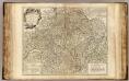
Suisses.
1 : 540000 Robert de Vaugondy, Gilles, 1688-1766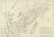
Mappa Situationem Fontium Danubii Aliorumq. Principaliorum Europae Fluminum Geographicè repraesentans: Quam Profila huc spectantia, cognitis per Barometrum Altitudinibus, Mathematicè ad oculum demonstrant
1 : 500000 Mollova mapová sbírka Marsili, Luigi Ferdinando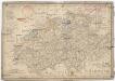
Die Schweiz
1 : 1590000 Švýcarsko
Charte von Helvetien
1 : 847000 Švýcarsko Kipferling, Karl Joseph J. Riedl's Kunsthandlung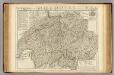
Suisse ou sont les Cantons.
1 : 514000 Merveilleux, David Francois de
Switzerland.
1 : 1050000 Schonberg & Co.
[Neuer Atlas der ganzen Erde nach den neuesten Bestimmungen ... : XIX.] Reise- und Höhen-Charte der Schweiz
Entworfen und gezeichnet von Dr. F.W. Streit H. Leutemann sc. Leipzig : J.C. Hinrichs'sche Buchhandlung