Maps of Sankt Gallen

<<Der>> Bund der III Waldstätte sammt dem grösseren Theile des Aar-, Thur- und Zürich-Gaues
1 : 925000 1 Karte [bearb. nach Urkunden und den vorzüglichsten Werken Schweizerischer Geschichte von E. Scheuermann] [Scheuermann], [Aarau]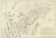
Mappa Situationem Fontium Danubii Aliorumq. Principaliorum Europae Fluminum Geographicè repraesentans: Quam Profila huc spectantia, cognitis per Barometrum Altitudinibus, Mathematicè ad oculum demonstrant
1 : 500000 Mollova mapová sbírka Marsili, Luigi Ferdinando
Niederschlagsmengen der Nordschweiz im Jahre 1891
1 : 1300000 1 Karte Schlumpf, Winterthur
Uebersichtskarte der Schweiz. Nordostbahn
1 : 400000 1 Karte Topogr. Anstalt Winterthur, J. Schlumpf, vorm. Wurster Randegger u. Co., Winterthur
Regenkarte der Nordostschweiz vom 3. Juni 1878
1 : 1000000 1 Karte Frey, Zürich
Karte des Kriegs-Schauplatzes der Schweiz
1 : 700000 2 Karten Verlag der Steiner'schen Buchhandlung, [Winterthur]
Switzerland
1 : 830000 Švýcarsko Keller, Raymond Walker, J. Society for the Diffusion of Useful Knowledge
[Reisekarte der Schweiz]
1 : 500000 1 Karte auf 6 Bl. gezeichnet v. H. Keller ; gest. v. J.J. Scheurmann [Füssli & Comp.], [Zürich]
Archäologische Karte der Ostschweiz
1 : 380000 1 Karte von Ferdinand Keller J. Wurster & Co., Zürich
Nova Helvetiae Tabula Geographica
1 : 380000 Mollova mapová sbírka Scheuchzer, Johann Jakob Schenk, Peter II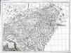
Carte pour l'histoire ancienne de l'Helvétie
1 Karte auf 4 Blatt : Kupferdruck ; 63 x 87 cm Bochat chés Bousquet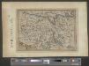
Zurichou
1 : 653000 1 Karte [Jodocus Hondius] [Printed by T. Cotes], [London]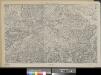
Eisenbahnprojecte der Central- und Ost-Schweiz
1 : 250000 1 Karte zusammengestellt vom zürch. Ingenieurs-Verein [Verlag nicht ermittelbar], [Erscheinungsort nicht ermittelbar]
Zurichou [i.e. Zürichgau]
1 : 600000 1 Karte [von Joannes Janssonius] [ex officina Ioannis Ianssonii], [Amsterodami]
Zurichgow
1 : 1000000 1 Karte [sumptibus et typis aenis Iudoci Hondij], [Amsterodami]
Original von Keller's zweiter Reisekarte der Schweiz
1 : 500000 1 Karte in 4 Teilen gest. v. J. Scheurmann Keller, Zürich
<<Le>> canton de Zurich
1 : 600000 1 Karte
[Kaart], uit: Carte scolaire du canton de Berne / [éd. par la dir. de l'instruction public du Canton de Berne ; executée par Kümmerly & Frey]
1 : 300000 Annotatie geografische gegevens: Bijkaart op achteromslag: Population et surface des districts du canton de Berne d'après le recensement fédéral de 1930 et la statistique de la superficie de 1923/24 Kümmerly+Frey, Bern Berne : Kümmerly & Frey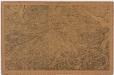
Projektierte Eisenbahnen der Zental- und Ostschweiz; Übersichtskarte
1 : 250000 Mit Legende. Zusammenstellung: Zürcher Ingenieurs-Verein Eidgenössisches Stabsbüro
Zurichgow et Basiliensis provincia
1 : 340000 1 Karte [Hondius oder Janssonius], [Amsterdam]
[Zurichgow, et Basiliensis provincia]
1 : 250000 1 Karte per Gerardum Mercatorem [sumptibus & typis aeneis Iudoci Hondij], [Amsterodami]
Zurichgow et Basiliensis provincia
1 : 340000 1 Karte [sumptibus & typis aeneis Henrici Hondij], [Amsterodami]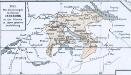
Das allmälige Wachsthum des österreichischen Staates. No. 45 Die Besitzungen des Hauses Habsburg in der Schweiz in ihrer grösten Ausdehnung
Schweiz Habsburger, Familie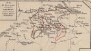
Die Besitzungen des Hauses Habsburg in der Schweiz in ihrer grössten Ausdehnung
Schweiz Habsburger, Familie
[Zurichgow, et Basiliensis provincia]
1 : 250000 1 Karte per Gerardum Mercatorem [Mercator], [Duisburg]
Zurichou [i.e. Zürichgau]
1 : 650000 1 Karte [von Jodocus Hondius] [excusum in aedibus Iudoci Hondij], [Amsterodami]
Carte de Suisse suivant sa nouvelle division en XVIII cantons formant la République Helvétique, 2
1 Blatt : chez F. Monty
[Zurichgow, et Basiliensis provincia]
1 : 250000 1 Karte per Gerardum Mercatorem [Mercator], [Duisburg]
Territorium der Republic Zürich
1 : 600000 1 Karte cura Ioh. Hofmeisteri


