Maps of Aargau

Zurichou [i.e. Zürichgau]
1 : 650000 1 Karte [von Jodocus Hondius] [excusum in aedibus Iudoci Hondij], [Amsterodami]
Zurichou [i.e. Zürichgau]
1 : 600000 1 Karte [von Joannes Janssonius] [ex officina Ioannis Ianssonii], [Amsterodami]
<<Le>> canton de Zurich
1 : 600000 1 Karte
Zurichgow
1 : 1000000 1 Karte [sumptibus et typis aenis Iudoci Hondij], [Amsterodami]
[Reisekarte der Schweiz]
1 : 500000 1 Karte auf 6 Bl. gezeichnet v. H. Keller ; gest. v. J.J. Scheurmann [Füssli & Comp.], [Zürich]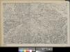
Eisenbahnprojecte der Central- und Ost-Schweiz
1 : 250000 1 Karte zusammengestellt vom zürch. Ingenieurs-Verein [Verlag nicht ermittelbar], [Erscheinungsort nicht ermittelbar]
Uebersichtskarte der Schweiz. Nordostbahn
1 : 400000 1 Karte Topogr. Anstalt Winterthur, J. Schlumpf, vorm. Wurster Randegger u. Co., Winterthur
Original von Keller's zweiter Reisekarte der Schweiz
1 : 500000 1 Karte in 4 Teilen gest. v. J. Scheurmann Keller, Zürich
[Zurichgow, et Basiliensis provincia]
1 : 250000 1 Karte per Gerardum Mercatorem [sumptibus & typis aeneis Iudoci Hondij], [Amsterodami]
[Zurichgow, et Basiliensis provincia]
1 : 250000 1 Karte per Gerardum Mercatorem [Mercator], [Duisburg]
[Zurichgow, et Basiliensis provincia]
1 : 250000 1 Karte per Gerardum Mercatorem [sumptibus & typis aeneis Iudoci Hondij], [Amsterodami]
Zurichgow et Basiliensis provincia
1 : 340000 1 Karte [sumptibus & typis aeneis Henrici Hondij], [Amsterodami]
Zurichgow et Basiliensis provincia
1 : 340000 1 Karte [Hondius oder Janssonius], [Amsterdam]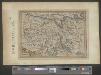
Zurichou
1 : 653000 1 Karte [Jodocus Hondius] [Printed by T. Cotes], [London]
Schulwandkarte zur Geschichte der Schweiz
1 : 180000 1 Karte auf 6 Bl. bearbeitet v. W. Oechsli u. A. Baldamus ; gezeichnet von Ed. Gaebler Kartograph. Verlagsanstalt von Georg Lang, Leipzig
Zurichgow et Basiliensis provincia
1 : 300000 1 Karte [apud Iohannem et Cornelium Blaeu], [Amsterdam]
[Zurichgow, et Basiliensis provincia]
1 : 250000 1 Karte per Gerardum Mercatorem [Mercator], [Duisburg]
Karte mit Teilen der Ost- und der Innerschweiz
Originaltitel: Le canton de Zurich. Möglicherweise: Bertius, Petrus (1565-1629), Geograf
Zurichgow et Basiliensis provincia
1 : 300000 1 Karte A. van den Broeck fecit apud Johannem Janssonium, Amstelodami
<<Der>> Bund der III Waldstätte sammt dem grösseren Theile des Aar-, Thur- und Zürich-Gaues
1 : 925000 1 Karte [bearb. nach Urkunden und den vorzüglichsten Werken Schweizerischer Geschichte von E. Scheuermann] [Scheuermann], [Aarau]
Neue und exacte geograph. Tabell von der Statt Zürich Gebiett
1 : 600000 1 Karte cura Ioh. Hofmeisteri ; Tobias Lobeck deli. et sculp.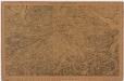
Projektierte Eisenbahnen der Zental- und Ostschweiz; Übersichtskarte
1 : 250000 Mit Legende. Zusammenstellung: Zürcher Ingenieurs-Verein Eidgenössisches Stabsbüro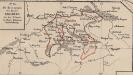
Die Besitzungen des Hauses Habsburg in der Schweiz in ihrer grössten Ausdehnung
Schweiz Habsburger, Familie
[Zurichgow, et Basiliensis provincia]
1 : 250000 1 Karte per Gerardum Mercatorem [Hondius], [Amsterdam]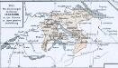
Das allmälige Wachsthum des österreichischen Staates. No. 45 Die Besitzungen des Hauses Habsburg in der Schweiz in ihrer grösten Ausdehnung
Schweiz Habsburger, Familie
Zvrichgow et Basiliensis provincia
1 Karte : Kupferdruck ; 37 x 48 cm Janssonius; Broeck apud Johannem Janssonium
Zvrichgow et Basiliensis provincia
1 Karte : Kupferdruck ; 37 x 48 cm Valck; Schenk; Broeck apud G. Valk et P. Schenk
Zvrichgow et Basiliensis provincia
1 Karte : Kupferdruck ; 37 x 48 cm Blaeu Willem Janszoon Blaeu
Zvrichgow et Basiliensis provincia
1 Karte : Kupferdruck ; 36 x 48 cm Mercator; Blaeu s.n.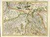
[Zurichgow, et Basiliensis provincia]
1 Karte : Kupferdruck ; 34 x 46 cm Mercator; Hondius Henricus Hondius
![Zurichou [i.e. Zürichgau]](https://images-2.georeferencer.com/images/iiif/499834867772/full/,300/0/native.jpg)

