Maps of Zug

Nova descriptio ditionis Tigurinae regionumque finitimarum
1 : 95000 1 Karte auf 6 Bl. Joh. Conradus Gygerus, P. delineavit ; Joh. Georgius Gygerus, F. in aes incidi ; curavit per Johannem Meyerum Ao. 1685
Nova descriptio ditionis Tigurinae regionumque finitimarum
1 : 95000 1 Karte auf 6 Bl. Joh. Conradus Gygerus, P. delineavit ; Joh. Georgius Gygerus, F. in aes incidi ; curavit per Johannem Meyerum Ao. 1685
Canton Inter Catholicos primaria, Sive Illustris Helvetiorum Respublica Lucernensis cum Subditis suis et confinibus recenter et accurate delineata
1 : 100000 Mollova mapová sbírka Walser, Gabriel Seutter, Albrecht Carl
Canton inter catholicos primaria, sive illustris Helvetiorum respublica Lucernensis cum subditis suis et confinibus
1 Karte : Kupferdruck ; 48 x 56 cm Walser; Seutter Albrecht Carl Seutter
Projektierte Eisenbahnstrecke Thalwil-Zug; Übersichtskarte
1 : 100000 Beilage zum Konzessionsgesuch der Nordostbahn. Eidgenössisches Topographisches Bureau, in Bern

Canton Lucern sive illustris helvetiorum respublica Lucernensis cum subditis suis et confinibus
1 Karte : Kupferdruck ; 46 x 55 cm Walser edentibus Homannianis Heredibus
Canton Lucern sive illustris helvetiorum respublica Lucernensis cum subditis suis et confinibus
1 Karte : Kupferdruck ; 46 x 55 cm Walser edentibus Homannianis Heredibus
Plan der Eisenbahnlinie Zürich-Zug-Luzern
1 : 100000 1 Karte Wurster, Winterthur
Relief pittoresque du sol classique de la Suisse
9 Karten dessiné d'après nature et gravé à l'eau forte par Frédéric Guillaume Delkeskamp ; terminé à l'aqua tinta par François Hegi et J.J. Sperli à Zuric = Malerisches Relief des klassischen Bodens der Schweiz / Nach der Natur gezeichnet und radirt von Friedrich Wilhelm Delkeskamp ; in Aqua tinta vollendet von Franz Hegi und J.J. Sperli in Zürich Friedrich Wilhelm Delkeskamp, Frankfurt a/M.
Topographische Karte des eidgenössischen Kantons Aargau
1 : 50000 1 Karte auf 4 Bl. im Auftrage der Staatsbehörden nach dem Massstabe von 1:25 000 in den Jahren 1837 bis 1843 aufgenommen und 1844/45 in den Massstab von 1:50 000 übertragen durch Ernst Heinrich Michaelis ; den Kupferstich besorgte 1845 bis 1848 Th. Delsol ; die Schrift J.M. Hacq Rud. Foppert, Zürich
Karte des Kantons Luzern
1 : 50000 1 Karte in 6 Blättern von J.S. Gerster J.J. Hofer, Zürich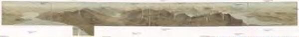
[Panoramatický pohled z vrcholu Rigi]

Topographische Karte des eidgenössischen Kantons Aargau im Auftrag der Staatsbehörden (Michaelis-Karte): Blatt 2
1 : 25000 Mit Sammelprofil. Michaelis, Ernst Heinrich (1794-1873), Ingenieurhauptmann und Kartograf, von Preussen Kupferstich: Delsol, Théodore (1819-1870), von Frankreich Schrift: Hacq, J. M.
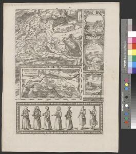
Atlas der alten Eidgenossenschaft in 20 Karten: Kanton Zug
Originaltitel: Canton Zug sive Pagus Helvetiae Tugiensis cum Confinibus. Mit Erklärung der Zeichen. Zeichnung: Walser, Gabriel (1695-1776), reformierter Pfarrer, von Teufen AR Herausgeber: Homännische Erben
Atlas novus Reipublicae Helveticae
1 Atlas ([40] Bl., 97 S.) bey Orell, Gessner und Compagnie, Zürich
Nova descriptio ditionis Tigurinæ, regionumque finitimarum, 4
1 Blatt : 49 x 36 cm Johann Jost Hiltensperger
Nova descriptio ditionis Tigurinæ, regionumque finitimarum, 4
1 Blatt : 50 x 37 cm s.n.
Canton Zug sive pagus Helvetiae Tugiensis cum confinibus
1 Karte : Kupferdruck ; 22 x 26 cm Walser Homännische Erben
Canton Zug sive pagus Helvetiæ Tugiensis cum confinibus
1 Karte : Kupferdruck ; 46 x 55 cm Walser edentibus Homann. Heredibus
Canton Zug sive pagus Helvetiæ Tugiensis cum confinibus
1 Karte : Kupferdruck ; 46 x 55 cm Walser edentibus Homann. Heredibus

Canton Zug sive Pagus Helvetiae Tugiensi cum Confinibus recenter delineatus
1 : 200000 Mollova mapová sbírka Walser, Gabriel Homann, Johann Baptista - dědici
Nr. 8: Militärquartier des Freiamts; Übersichtskarte
1 : 45000 Originaltitel: Das Freyammbts Quartier, Sampt den nechst anstossenden Qvartieren vnd Landschafften. Ohne Datumsangabe. Gyger, Hans Conrad, andere Schreibweisen: Geiger, Geyger, (1599-1674), Kartograf, Ingenieur und Amtmann des Amts Kappelerhof, von Zürich
Nr. 8: Militärquartier des Freiamts; Übersichtskarte von ca. 1659
Handgezeichnete Kopie der von Hans Conrad Gyger, andere Schreibweisen: Geiger, Geyger, (1599-1674), Kartograf, Ingenieur und Amtmann des Amts Kappelerhof, von Zürich, verfertigten Originalkarte. Spitteler, Sigmund (1732-1818), Ingenieur und Strassenbauinspektor des Kantons Zürich, von Läufelfingen BL und Hottingen
Kanton Zürich: Staats-, Gemeinde- und Genossenschaftswaldungen: Blatt 13: Gegend bei Kappel am Albis, Maschwanden, Mettmenstetten und Aeugst am Albis; Situationsplan
1 : 25000 Auf Ausgangskarten angebrachte farbige Eintragungen und Einzeichnungen. Ohne Erstellungsdatumsangabe. Ausgangskarten: Blätter 173 (Merenschwand), 176 (Mettmenstetten), 187 (Hochdorf) und 190 (Cham) des Topographischen Atlasses der Schweiz (Siegfried-Karte). Hartmann, Karl, Forstadjunkt im Zürcher Oberforstamt, von Aarau, in Unterstrass
Rigi
1 : 50000 Becker, Fridolin Schlumpf
Topographische Karte des Kantons Luzern
1 : 25000 Blatt 3 H. Müllhaupt u. Sohn H. Müllhaupt u. Sohn