Maps of Bezirk Muri

Topographische Karte des eidgenössischen Kantons Aargau
1 : 50000 1 Karte auf 4 Bl. im Auftrage der Staatsbehörden nach dem Massstabe von 1:25 000 in den Jahren 1837 bis 1843 aufgenommen und 1844/45 in den Massstab von 1:50 000 übertragen durch Ernst Heinrich Michaelis ; den Kupferstich besorgte 1845 bis 1848 Th. Delsol ; die Schrift J.M. Hacq Rud. Foppert, Zürich
Topographische Karte des eidgenössischen Kantons Aargau im Auftrag der Staatsbehörden (Michaelis-Karte): Blatt 2
1 : 25000 Mit Sammelprofil. Michaelis, Ernst Heinrich (1794-1873), Ingenieurhauptmann und Kartograf, von Preussen Kupferstich: Delsol, Théodore (1819-1870), von Frankreich Schrift: Hacq, J. M.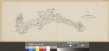
Plan der Eisenbahnlinie Zürich-Zug-Luzern
1 : 100000 1 Karte Wurster, Winterthur
Relief pittoresque du sol classique de la Suisse
9 Karten dessiné d'après nature et gravé à l'eau forte par Frédéric Guillaume Delkeskamp ; terminé à l'aqua tinta par François Hegi et J.J. Sperli à Zuric = Malerisches Relief des klassischen Bodens der Schweiz / Nach der Natur gezeichnet und radirt von Friedrich Wilhelm Delkeskamp ; in Aqua tinta vollendet von Franz Hegi und J.J. Sperli in Zürich Friedrich Wilhelm Delkeskamp, Frankfurt a/M.
Eigentliche Verzeichnuss der Stätten, Graffschaften und Herrschaften, welche in der Statt Zürich Gebiet und Landschaft gehörig sind
1 : 56000 1 Karte auf 16 Bl. gerissen durch Josen Murern
Karte des Kantons Luzern
1 : 50000 1 Karte in 6 Blättern von J.S. Gerster J.J. Hofer, Zürich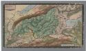
Nr. 8: Militärquartier des Freiamts; Übersichtskarte
1 : 45000 Originaltitel: Das Freyammbts Quartier, Sampt den nechst anstossenden Qvartieren vnd Landschafften. Ohne Datumsangabe. Gyger, Hans Conrad, andere Schreibweisen: Geiger, Geyger, (1599-1674), Kartograf, Ingenieur und Amtmann des Amts Kappelerhof, von Zürich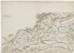
Nr. 8: Militärquartier des Freiamts; Übersichtskarte von ca. 1659
Handgezeichnete Kopie der von Hans Conrad Gyger, andere Schreibweisen: Geiger, Geyger, (1599-1674), Kartograf, Ingenieur und Amtmann des Amts Kappelerhof, von Zürich, verfertigten Originalkarte. Spitteler, Sigmund (1732-1818), Ingenieur und Strassenbauinspektor des Kantons Zürich, von Läufelfingen BL und Hottingen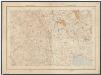
Kanton Zürich: Staats-, Gemeinde- und Genossenschaftswaldungen: Blatt 13: Gegend bei Kappel am Albis, Maschwanden, Mettmenstetten und Aeugst am Albis; Situationsplan
1 : 25000 Auf Ausgangskarten angebrachte farbige Eintragungen und Einzeichnungen. Ohne Erstellungsdatumsangabe. Ausgangskarten: Blätter 173 (Merenschwand), 176 (Mettmenstetten), 187 (Hochdorf) und 190 (Cham) des Topographischen Atlasses der Schweiz (Siegfried-Karte). Hartmann, Karl, Forstadjunkt im Zürcher Oberforstamt, von Aarau, in Unterstrass
Nova descriptio ditionis Tigurinæ, regionumque finitimarum, 4
1 Blatt : 49 x 36 cm Johann Jost Hiltensperger
Nova descriptio ditionis Tigurinæ, regionumque finitimarum, 4
1 Blatt : 50 x 37 cm s.n.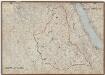
Kanton Zürich: Wassernutzungskataster; Übersichtskarten: Bezirk Affoltern
1 : 25000 Ausgangskarten (zusammengesetzt): Ausschnitte der Blätter 157 (Bremgarten), 160 (Birmensdorf), 161 (Zürich), 171 (Bünzen), 173 (Merenschwand), 174 (Affoltern), 175 (Thalwil), 176 (Mettmenstetten), 177 (Horgen), 190 (Cham) und 191 (Zug) des Topographischen Atlasses der Schweiz (Siegfried-Karte). Ausgangskarten Leitung: Siegfried, Hermann (1819-1879), Topograf und Kartograf, von Zofingen AG; Eidgenössisches Topographisches Bureau, in Bern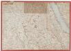
Kanton Zürich: Wasserbenutzungsrechtkataster; Übersichtskarten: Bezirk Affoltern
1 : 25000 Ausgangskarte: Blatt 160 (Birmensdorf) des Topographischen Atlasses der Schweiz (Siegfried-Karte). Ausgangskarten Leitung: Siegfried, Hermann (1819-1879), Topograf und Kartograf, von Zofingen AG; Eidgenössisches Topographisches Bureau, in Bern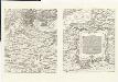
Karte des Zürcher Gebiets (Murer-Karte) von 1566
1 : 56000 Originaltitel: Eigentliche Verzeichnuss der Stätten, Graffschaften, und Herrschaften, welche in der Statt Zürich Gebiet und Landschafft gehörig seind. Neudruck (9. Auflage) der von Jos Murer verfertigten Originalkarte. 6 Blätter, 10 Bordüren. Druck und Verlag: Grafische Kunstwerkstätte Emil Matthieu, in Zürich
Wandkarte des Cantons Zürich
1 : 50000 Südwest-Blatt Keller, Heinrich Heinrich Keller
Karte des Kantons Zürich: Blatt 3: Südwesten
1 : 33333
Zürich: Kriegsschauplatz auf der Albiskette; Situationsplan
Mit Erklärung der Zeichen und Erläuterungen zu den ab dem 06.06.1799 stattfindenden Gefechten. Zeichnung und Stick: Meyer, J. H.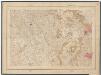
Kanton Zürich: Staats-, Gemeinde- und Genossenschaftswaldungen: Blatt 10: Gegend bei Ottenbach sowie zwischen Affoltern am Albis und Uitikon; Situationsplan
1 : 25000 Auf Ausgangskarten angebrachte farbige Eintragungen und Einzeichnungen. Ohne Erstellungsdatumsangabe. Ausgangskarten: Blätter 157 (Bremgarten), 160 (Birmensdorf), 171 (Muri) und 174 (Affoltern am Albis) des Topographischen Atlasses der Schweiz (Siegfried-Karte). Hartmann, Karl, Forstadjunkt im Zürcher Oberforstamt, von Aarau, in Unterstrass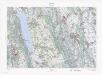
Landeskarte der Schweiz 1 : 25000: Den Kanton Zürich betreffende Blätter: Blatt 1110: Hitzkirch LU
1 : 25000 Stand des Karteninhalts: 2013. Bundesamt für Landestopografie swisstopo, in Köniz-Wabern
Topographische Karte des Kantons Luzern
1 : 25000 Blatt 3 H. Müllhaupt u. Sohn H. Müllhaupt u. Sohn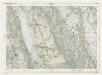
Landeskarte der Schweiz 1 : 25000: Den Kanton Zürich betreffende Blätter: Blatt 1110: Hitzkirch LU
1 : 25000 Erstausgabe 1953; Nachführung 1957. Eidgenössische Landestopographie, in Köniz-Wabern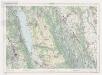
Landeskarte der Schweiz 1 : 25000: Den Kanton Zürich betreffende Blätter: Blatt 1110: Hitzkirch LU
1 : 25000 Erstausgabe 1953; Nachführungen 1963, 1970, 1976, 1982, 1988. Bundesamt für Landestopographie, in Köniz-Wabern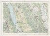
Landeskarte der Schweiz 1 : 25000: Den Kanton Zürich betreffende Blätter: Blatt 1110: Hitzkirch LU
1 : 25000 Erstausgabe 1953; Nachführungen 1963, 1970. Eidgenössische Landestopographie, in Köniz-Wabern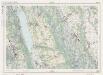
Landeskarte der Schweiz 1 : 25000: Den Kanton Zürich betreffende Blätter: Blatt 1110: Hitzkirch LU
1 : 25000 Erstausgabe 1953; Nachführungen 1963, 1970, 1976, 1982. Bundesamt für Landestopographie, in Köniz-Wabern
Hans Konrad Gyger's Züricher-Cantons-Carte 1667
1 : 32000 1 Karte in 56 Teilen Hans Konrad Gyger
Topographische Karte des Kantons Luzern
1 : 25000 Blatt 4 H. Müllhaupt u. Sohn H. Müllhaupt u. Sohn
Affoltern
1 : 25000 1 Karte [Lithographie: Josef Graf]
Knonau
1 : 25000 1 Karte [Lithographie: Josef Graf]
Hans Konrad Gyger's Züricher-Cantons-Carte 1667
1 : 32000 1 Karte in 56 Teilen Hans Konrad Gyger


