Maps of Zug

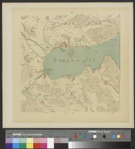
Hans Konrad Gyger's Züricher-Cantons-Carte 1667
1 : 32000 1 Karte in 56 Teilen Hans Konrad Gyger
Landeskarte der Schweiz 1 : 25000: Den Kanton Zürich betreffende Blätter: Blatt 1131: Zug
1 : 25000 Erstausgabe 1956; Nachführungen 1965, 1971. Eidgenössische Landestopographie, in Köniz-Wabern
Landeskarte der Schweiz 1 : 25000: Den Kanton Zürich betreffende Blätter: Blatt 1131: Zug
1 : 25000 Erstausgabe 1956; Nachführungen 1965, 1971, 1976, 1982, 1987, 1994, 2000. Bundesamt für Landestopografie swisstopo, in Köniz-Wabern
Landeskarte der Schweiz 1 : 25000: Den Kanton Zürich betreffende Blätter: Blatt 1131: Zug
1 : 25000 Erstausgabe 1956; Nachführungen 1965, 1971, 1976, 1982, 1987. Bundesamt für Landestopographie, in Köniz-Wabern
Landeskarte der Schweiz 1 : 25000: Den Kanton Zürich betreffende Blätter: Blatt 1131: Zug
1 : 25000 Stand des Karteninhalts: 2013. Bundesamt für Landestopografie swisstopo, in Köniz-Wabern
Landeskarte der Schweiz 1 : 25000: Den Kanton Zürich betreffende Blätter: Blatt 1131: Zug
1 : 25000 Erstausgabe 1956. Eidgenössische Landestopographie, in Köniz-Wabern
Landeskarte der Schweiz 1 : 25000: Den Kanton Zürich betreffende Blätter: Blatt 1131: Zug
1 : 25000 Erstausgabe 1956; Nachführungen 1965, 1971, 1976, 1982, 1987, 1994. Bundesamt für Landestopographie, in Köniz-Wabern
Landeskarte der Schweiz 1 : 25000: Den Kanton Zürich betreffende Blätter: Blatt 1131: Zug
1 : 25000 Erstausgabe 1956; Nachführungen 1965, 1971, 1976, 1982. Bundesamt für Landestopographie, in Köniz-Wabern
Landeskarte der Schweiz 1 : 25000: Den Kanton Zürich betreffende Blätter: Blatt 1131: Zug
1 : 25000 Erstausgabe 1956; Nachführungen 1965, 1971, 1976, 1982, 1987, 1994, 2000, 2007, 2008. Bundesamt für Landestopografie swisstopo, in Köniz-Wabern
Topographische Karte des Kantons Luzern
1 : 25000 Blatt 4 H. Müllhaupt u. Sohn H. Müllhaupt u. Sohn
Knonau
1 : 25000 1 Karte [Lithographie: Josef Graf]
Grosse Landtafel des Zürcher Gebiets: Blatt 40: Zug und Umgebung
Möglicherweise: Wagner, Johann (1675-1714)
Hans Konrad Gyger's Züricher-Cantons-Carte
1 : 32000 Blatt 40 Gyger, Hans Conrad ; Zeller-Werdmüller, Heinrich Hofer & Burger
Topographischer Atlas der Schweiz (Siegfried-Karte): Den Kanton Zürich betreffende Blätter: Blatt 190: Cham
1 : 25000 Erstausgabe 1887. Leitung: Siegfried, Hermann (1819-1879), Topograf und Kartograf, von Zofingen AG; Eidgenössisches Topographisches Bureau, in Bern Aufnahme: Hörnlimann, Jakob (1846-1933), Ingenieur; Pestalozzi, Karl, andere Schreibweise: Carl, (1825-1891), Ingenieur, von Zürich; Stucky, H. Revision: Benz, J. Stich: Müllhaupt, F.
Topographischer Atlas der Schweiz (Siegfried-Karte): Den Kanton Zürich betreffende Blätter: Blatt 190: Cham
1 : 25000 Erstausgabe 1878; Nachführungen 1898, 1908, 1910, 1919. Leitung: Siegfried, Hermann (1819-1879), Topograf und Kartograf, von Zofingen AG; Eidgenössisches Topographisches Bureau, in Bern Aufnahme: Hörnlimann, Jakob (1846-1933), Ingenieur; Pestalozzi, Karl, andere Schreibweise: Carl, (1825-1891), Ingenieur, von Zürich; Stucky, H. Revision: Benz, J. Stich: Müllhaupt, F. Druck: Eidgenössische Landestopographie
Kanton Zürich: Waldungen, Rebberge und Rodungen um die Mitte des 17. Jahrhunderts: Blatt XXIX: Knonau
1 : 25000 Ohne Erstellungsdatumsangabe. Ausgangskarte: Blatt XXIX (Knonau) der Topographischen Karte des Kantons Zürich (Wild-Karte). Tirkanits, Miklos, andere Schreibweise: Nikolaus, (geb. 1923), Ingenieur und Assistent für Kartografie an der Eidgenössischen Technischen Hochschule Zürich, von Ungarn Ausgangskarte Leitung: Wild, Johannes (1814-1894), Ingenieur sowie Strassen- und Wasserbauinspektor des Kantons Zürich, von Richterswil Ausgangskarte Zeichnung: Enderli, Heinrich (1830-1902), Zeichner, von Wipkingen Ausgangskarte Stich: Brack, Johann Jakob (1824-1867), Lithograf, von Neunforn TG
Vorlagen für die Topographische Karte des Kantons Zürich (Wild-Karte): Schrift-Pausen: Blatt XXIX: Knonau
1 : 25000
Knonau
1 : 25000 Karte des Kantons Zürich im Masstab von 1:25 000, Blatt 29 Wild, Johannes Topographisches Bureau
Grenze zwischen den Kantonen Zürich und Zug bei Knonau; Übersichtskarte
1 : 25000 Mit handschriftlichen Einzeichnungen. Ausgangskarte: Blatt XXIX (Knonau) der Topographischen Karte des Kantons Zürich (Wild-Karte). Meyer-Näf, Hs. Ausgangskarte Leitung: Wild, Johannes (1814-1894), Ingenieur sowie Strassen- und Wasserbauinspektor des Kantons Zürich, von Richterswil Ausgangskarte Zeichnung: Enderli, Heinrich (1830-1902), Zeichner, von Wipkingen Ausgangskarte Stich: Graf, Josef (1811-1871), Lithograf, von Rottweil (Deutschland)
Topographische Karte des Kantons Zürich (Wild-Karte): Blatt XXIX: Knonau
1 : 25000 Leitung: Wild, Johannes (1814-1894), Ingenieur sowie Strassen- und Wasserbauinspektor des Kantons Zürich, von Richterswil Zeichnung: Enderli, Heinrich (1830-1902), Zeichner, von Wipkingen Stich: Graf, Josef (1811-1871), Lithograf, von Rottweil (Deutschland)
Knonau
1 : 25000 Graf, Josef [Topographisches Bureau]
Übersichtskarte zu den Truppenbewegungen am 23ten November 1847
1 : 25000 1 Karte Topogr. Anstalt v. J. Wurster u. Comp. [Friedrich Schulthess], [Zürich]
Hans Konrad Gyger's Züricher-Cantons-Carte
1 : 32000 Blatt 48 Gyger, Hans Conrad ; Zeller-Werdmüller, Heinrich Hofer & Burger
Grosse Landtafel des Zürcher Gebiets: Blatt 48: Eschenbach und Umgebung
Möglicherweise: Wagner, Johann (1675-1714)
Topographischer Atlas der Schweiz (Siegfried-Karte): Den Kanton Zürich betreffende Blätter: Blatt 191: Zug
1 : 25000 Erstausgabe 1887; Nachführungen 1897, 1910, 1915, 1919. Leitung: Siegfried, Hermann (1819-1879), Topograf und Kartograf, von Zofingen AG; Eidgenössisches Topographisches Bureau, in Bern Aufnahme: Lindenmann, H.; Wetli, Kaspar, andere Schreibweise: Wethli, (1822-1889), Ingenieur, von Männedorf Revision: Benz, J. Stich: Müllhaupt, F. Druck: Eidgenössische Landestopographie
Knonau: Gesamtmelioration, alter Bestand 1956 und neuer Bestand 1969; Übersichtskarte
1 : 15000 Mit Legende und Erläuterungen. Projektverfassung: Lüscher, H., Ingenieur- und Vermessungsbüro, in Zürich Reproduktion: Orell Füssli Graphische Betriebe AG, in Zürich
Strittige Grenze zwischen dem Zürcher und dem Zuger Gebiet bei Ebertswil und Kappel am Albis; Übersichtsplan
1 : 10000 Ohne Datumsangabe (Datierung gemäss Angabe Samuel Wyders in: Grenz-, Zehnten- und Befestigungspläne des Zürcher Gebiets von Hans Conrad Gyger, S. 19). Gyger, Hans Conrad, andere Schreibweisen: Geiger, Geyger, (1599-1674), Kartograf, Ingenieur und Amtmann des Amts Kappelerhof, von Zürich
Kappel am Albis: Gesamtmelioration, alter Bestand 1966 und neuer Bestand 1974; Übersichtsplan
1 : 15000 Mit Legende und Erläuterungen. Projektverfassung: Leckebusch, Püntener und Werder (vormals Bregenzer, Walter), Ingenieur- und Vermessungsbüro, in Affoltern am Albis
Plan der Stadt Zug
1 : 4000 1 Karte Kartographia Winterthur, Winterthur