Maps of Zug

Nova descriptio ditionis Tigurinæ, regionumque finitimarum, 4
1 Blatt : 49 x 36 cm Johann Jost Hiltensperger
Nova descriptio ditionis Tigurinæ, regionumque finitimarum, 4
1 Blatt : 50 x 37 cm s.n.
Hans Konrad Gyger's Züricher-Cantons-Carte 1667
1 : 32000 1 Karte in 56 Teilen Hans Konrad Gyger
Topographische Karte des Kantons Luzern
1 : 25000 Blatt 4 H. Müllhaupt u. Sohn H. Müllhaupt u. Sohn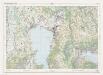
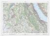
Landeskarte der Schweiz 1 : 25000: Den Kanton Zürich betreffende Blätter: Blatt 1131: Zug
1 : 25000 Erstausgabe 1956; Nachführungen 1965, 1971. Eidgenössische Landestopographie, in Köniz-Wabern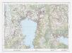
Landeskarte der Schweiz 1 : 25000: Den Kanton Zürich betreffende Blätter: Blatt 1131: Zug
1 : 25000 Erstausgabe 1956; Nachführungen 1965, 1971, 1976, 1982, 1987, 1994, 2000. Bundesamt für Landestopografie swisstopo, in Köniz-Wabern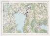
Landeskarte der Schweiz 1 : 25000: Den Kanton Zürich betreffende Blätter: Blatt 1131: Zug
1 : 25000 Erstausgabe 1956; Nachführungen 1965, 1971, 1976, 1982, 1987. Bundesamt für Landestopographie, in Köniz-Wabern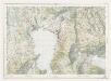
Landeskarte der Schweiz 1 : 25000: Den Kanton Zürich betreffende Blätter: Blatt 1131: Zug
1 : 25000 Erstausgabe 1956. Eidgenössische Landestopographie, in Köniz-Wabern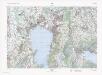
Landeskarte der Schweiz 1 : 25000: Den Kanton Zürich betreffende Blätter: Blatt 1131: Zug
1 : 25000 Stand des Karteninhalts: 2013. Bundesamt für Landestopografie swisstopo, in Köniz-Wabern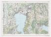
Landeskarte der Schweiz 1 : 25000: Den Kanton Zürich betreffende Blätter: Blatt 1131: Zug
1 : 25000 Erstausgabe 1956; Nachführungen 1965, 1971, 1976, 1982, 1987, 1994. Bundesamt für Landestopographie, in Köniz-Wabern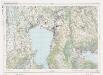
Landeskarte der Schweiz 1 : 25000: Den Kanton Zürich betreffende Blätter: Blatt 1131: Zug
1 : 25000 Erstausgabe 1956; Nachführungen 1965, 1971, 1976, 1982. Bundesamt für Landestopographie, in Köniz-Wabern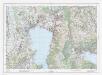
Landeskarte der Schweiz 1 : 25000: Den Kanton Zürich betreffende Blätter: Blatt 1131: Zug
1 : 25000 Erstausgabe 1956; Nachführungen 1965, 1971, 1976, 1982, 1987, 1994, 2000, 2007, 2008. Bundesamt für Landestopografie swisstopo, in Köniz-Wabern
Knonau
1 : 25000 1 Karte [Lithographie: Josef Graf]
Hans Konrad Gyger's Züricher-Cantons-Carte 1667
1 : 32000 1 Karte in 56 Teilen Hans Konrad Gyger
Eigentliche Verzeichnuss der Staetten, Grafschaften und Herschaften welche in der Statt Zuerich Gebiet und Landschaft gehoerig sind, 4
1 Blatt : 45 x 38 cm Conrad Orell und Comp.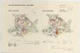
Rifferswil: Güterzusammenlegung, alter Bestand 1937 und neuer Bestand 1939; Übersichtsplan
1 : 15000 Mit Legende. Reproduktion: Art. Institut Orell Füssli AG, in Zürich
Topographischer Atlas der Schweiz (Siegfried-Karte): Den Kanton Zürich betreffende Blätter: Blatt 190: Cham
1 : 25000 Erstausgabe 1887. Leitung: Siegfried, Hermann (1819-1879), Topograf und Kartograf, von Zofingen AG; Eidgenössisches Topographisches Bureau, in Bern Aufnahme: Hörnlimann, Jakob (1846-1933), Ingenieur; Pestalozzi, Karl, andere Schreibweise: Carl, (1825-1891), Ingenieur, von Zürich; Stucky, H. Revision: Benz, J. Stich: Müllhaupt, F.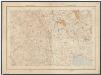
Kanton Zürich: Staats-, Gemeinde- und Genossenschaftswaldungen: Blatt 13: Gegend bei Kappel am Albis, Maschwanden, Mettmenstetten und Aeugst am Albis; Situationsplan
1 : 25000 Auf Ausgangskarten angebrachte farbige Eintragungen und Einzeichnungen. Ohne Erstellungsdatumsangabe. Ausgangskarten: Blätter 173 (Merenschwand), 176 (Mettmenstetten), 187 (Hochdorf) und 190 (Cham) des Topographischen Atlasses der Schweiz (Siegfried-Karte). Hartmann, Karl, Forstadjunkt im Zürcher Oberforstamt, von Aarau, in Unterstrass
Grosse Landtafel des Zürcher Gebiets: Blatt 40: Zug und Umgebung
Möglicherweise: Wagner, Johann (1675-1714)
Topographischer Atlas der Schweiz (Siegfried-Karte): Den Kanton Zürich betreffende Blätter: Blatt 190: Cham
1 : 25000 Erstausgabe 1878; Nachführungen 1898, 1908, 1910, 1919. Leitung: Siegfried, Hermann (1819-1879), Topograf und Kartograf, von Zofingen AG; Eidgenössisches Topographisches Bureau, in Bern Aufnahme: Hörnlimann, Jakob (1846-1933), Ingenieur; Pestalozzi, Karl, andere Schreibweise: Carl, (1825-1891), Ingenieur, von Zürich; Stucky, H. Revision: Benz, J. Stich: Müllhaupt, F. Druck: Eidgenössische Landestopographie
Hans Konrad Gyger's Züricher-Cantons-Carte
1 : 32000 Blatt 40 Gyger, Hans Conrad ; Zeller-Werdmüller, Heinrich Hofer & Burger
Kanton Zürich: Waldungen, Rebberge und Rodungen um die Mitte des 17. Jahrhunderts: Blatt XXIX: Knonau
1 : 25000 Ohne Erstellungsdatumsangabe. Ausgangskarte: Blatt XXIX (Knonau) der Topographischen Karte des Kantons Zürich (Wild-Karte). Tirkanits, Miklos, andere Schreibweise: Nikolaus, (geb. 1923), Ingenieur und Assistent für Kartografie an der Eidgenössischen Technischen Hochschule Zürich, von Ungarn Ausgangskarte Leitung: Wild, Johannes (1814-1894), Ingenieur sowie Strassen- und Wasserbauinspektor des Kantons Zürich, von Richterswil Ausgangskarte Zeichnung: Enderli, Heinrich (1830-1902), Zeichner, von Wipkingen Ausgangskarte Stich: Brack, Johann Jakob (1824-1867), Lithograf, von Neunforn TG
Topographischer Atlas der Schweiz (Siegfried-Karte): Den Kanton Zürich betreffende Blätter: Blatt 176: Mettmenstetten
1 : 25000 Erstausgabe 1884. Leitung: Siegfried, Hermann (1819-1879), Topograf und Kartograf, von Zofingen AG; Eidgenössisches Topographisches Bureau, in Bern Aufnahme: Pestalozzi, Karl, andere Schreibweise: Carl, (1825-1891), Ingenieur, von Zürich; Stucky, H.; Wetli, Kaspar, andere Schreibweise: Wethli, (1822-1889), Ingenieur, von Männedorf Revision: Benz, J. Stich: Müllhaupt, Heinrich (1820-1894), Kupferstecher und Kartograf, von Hofstetten; Müllhaupt, Fritz (1846-1917), von Hofstetten
Gewässergebiete des Kantons Zürich; Situationspläne: Hausen am Albis und Kappel am Albis
1 : 2500 Mit Gemeindenummerierung. Ohne Datumsangabe.
Original-Messtischaufnahmen für die Topographische Karte des Kantons Zürich (Wild-Karte): Blatt 3: Affoltern am Albis
1 : 25000 Pestalozzi, Karl, andere Schreibweise: Carl, (1825-1891), Ingenieur, von Zürich
Affoltern
1 : 25000 1 Karte [Lithographie: Josef Graf]
Gewässergebiete des Kantons Zürich; Situationspläne: Maschwanden, Obfelden, Ottenbach
1 : 2500 Mit Gemeindenummerierung. Ohne Datumsangabe.
Hirzel
1 : 25000 Karte des Kantons Zürich im Masstab von 1:25 000, Blatt 30 Wild, Johannes Topographisches Bureau
Hans Konrad Gyger's Züricher-Cantons-Carte 1667
1 : 32000 1 Karte in 56 Teilen Hans Konrad Gyger