Maps of Zug

Canton Zug sive pagus Helvetiae Tugiensis cum confinibus
1 Karte : Kupferdruck ; 22 x 26 cm Walser Homännische Erben
Canton Zug sive pagus Helvetiæ Tugiensis cum confinibus
1 Karte : Kupferdruck ; 46 x 55 cm Walser edentibus Homann. Heredibus

Canton Zug sive Pagus Helvetiae Tugiensi cum Confinibus recenter delineatus
1 : 200000 Mollova mapová sbírka Walser, Gabriel Homann, Johann Baptista - dědici
Atlas der alten Eidgenossenschaft in 20 Karten: Kanton Zug
Originaltitel: Canton Zug sive Pagus Helvetiae Tugiensis cum Confinibus. Mit Erklärung der Zeichen. Zeichnung: Walser, Gabriel (1695-1776), reformierter Pfarrer, von Teufen AR Herausgeber: Homännische Erben
Canton Zug sive pagus Helvetiæ Tugiensis cum confinibus
1 Karte : Kupferdruck ; 46 x 55 cm Walser edentibus Homann. Heredibus
Atlas novus Reipublicae Helveticae
1 Atlas ([40] Bl., 97 S.) bey Orell, Gessner und Compagnie, Zürich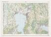
Landeskarte der Schweiz 1 : 25000: Den Kanton Zürich betreffende Blätter: Blatt 1131: Zug
1 : 25000 Erstausgabe 1956; Nachführungen 1965, 1971. Eidgenössische Landestopographie, in Köniz-Wabern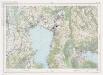
Landeskarte der Schweiz 1 : 25000: Den Kanton Zürich betreffende Blätter: Blatt 1131: Zug
1 : 25000 Erstausgabe 1956; Nachführungen 1965, 1971, 1976, 1982, 1987. Bundesamt für Landestopographie, in Köniz-Wabern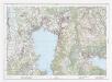
Landeskarte der Schweiz 1 : 25000: Den Kanton Zürich betreffende Blätter: Blatt 1131: Zug
1 : 25000 Erstausgabe 1956; Nachführungen 1965, 1971, 1976, 1982, 1987, 1994, 2000. Bundesamt für Landestopografie swisstopo, in Köniz-Wabern
Hans Konrad Gyger's Züricher-Cantons-Carte 1667
1 : 32000 1 Karte in 56 Teilen Hans Konrad Gyger
Nova descriptio ditionis Tigurinæ, regionumque finitimarum, 4
1 Blatt : 49 x 36 cm Johann Jost Hiltensperger
Nova descriptio ditionis Tigurinæ, regionumque finitimarum, 4
1 Blatt : 50 x 37 cm s.n.
Rigi
1 : 50000 Becker, Fridolin Schlumpf
Eigentliche Verzeichnuss der Stätten, Graffschaften und Herrschaften, welche in der Statt Zürich Gebiet und Landschaft gehörig sind
1 : 56000 1 Karte auf 16 Bl. gerissen durch Josen Murern
Eigentliche Verzeichnuss der Staetten, Grafschaften und Herschaften welche in der Statt Zuerich Gebiet und Landschaft gehoerig sind, 4
1 Blatt : 45 x 38 cm Conrad Orell und Comp.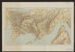
Excursionskarte vom Rigi
1 : 12500 Kartogr. Anstalt von Hofer & Co.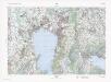
Landeskarte der Schweiz 1 : 25000: Den Kanton Zürich betreffende Blätter: Blatt 1131: Zug
1 : 25000 Stand des Karteninhalts: 2013. Bundesamt für Landestopografie swisstopo, in Köniz-Wabern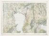
Landeskarte der Schweiz 1 : 25000: Den Kanton Zürich betreffende Blätter: Blatt 1131: Zug
1 : 25000 Erstausgabe 1956. Eidgenössische Landestopographie, in Köniz-Wabern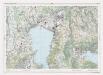
Landeskarte der Schweiz 1 : 25000: Den Kanton Zürich betreffende Blätter: Blatt 1131: Zug
1 : 25000 Erstausgabe 1956; Nachführungen 1965, 1971, 1976, 1982, 1987, 1994. Bundesamt für Landestopographie, in Köniz-Wabern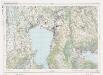
Landeskarte der Schweiz 1 : 25000: Den Kanton Zürich betreffende Blätter: Blatt 1131: Zug
1 : 25000 Erstausgabe 1956; Nachführungen 1965, 1971, 1976, 1982. Bundesamt für Landestopographie, in Köniz-Wabern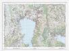
Landeskarte der Schweiz 1 : 25000: Den Kanton Zürich betreffende Blätter: Blatt 1131: Zug
1 : 25000 Erstausgabe 1956; Nachführungen 1965, 1971, 1976, 1982, 1987, 1994, 2000, 2007, 2008. Bundesamt für Landestopografie swisstopo, in Köniz-Wabern
Hans Konrad Gyger's Züricher-Cantons-Carte 1667
1 : 32000 1 Karte in 56 Teilen Hans Konrad Gyger
Plan des verschütteten Thals zwischen dem Lowerzer u. Zuger-See
1 : 45000 1 Karte J. Fehr del. ; F. Hegi sculp.
Topographischer Atlas der Schweiz (Siegfried-Karte): Den Kanton Zürich betreffende Blätter: Blatt 191: Zug
1 : 25000 Erstausgabe 1887. Leitung: Siegfried, Hermann (1819-1879), Topograf und Kartograf, von Zofingen AG; Eidgenössisches Topographisches Bureau, in Bern Aufnahme: Lindenmann, H.; Wetli, Kaspar, andere Schreibweise: Wethli, (1822-1889), Ingenieur, von Männedorf Revision: Benz, J. Stich: Müllhaupt, F.
Grosse Landtafel des Zürcher Gebiets: Blatt 40: Zug und Umgebung
Möglicherweise: Wagner, Johann (1675-1714)
Hans Konrad Gyger's Züricher-Cantons-Carte
1 : 32000 Blatt 40 Gyger, Hans Conrad ; Zeller-Werdmüller, Heinrich Hofer & Burger
Topographischer Atlas der Schweiz (Siegfried-Karte): Den Kanton Zürich betreffende Blätter: Blatt 242: Richterswil
1 : 25000 Erstausgabe 1888; Nachführungen 1894, 1907, 1920. Leitung: Siegfried, Hermann (1819-1879), Topograf und Kartograf, von Zofingen AG; Eidgenössisches Topographisches Bureau, in Bern Aufnahme: Suter, S.; Wetli, Kaspar, andere Schreibweise: Wethli, (1822-1889), Ingenieur, von Männedorf Stich: Müllhaupt, F. Druck: Eidgenössische Landestopographie
Topographischer Atlas der Schweiz (Siegfried-Karte): Den Kanton Zürich betreffende Blätter: Blatt 190: Cham
1 : 25000 Erstausgabe 1887. Leitung: Siegfried, Hermann (1819-1879), Topograf und Kartograf, von Zofingen AG; Eidgenössisches Topographisches Bureau, in Bern Aufnahme: Hörnlimann, Jakob (1846-1933), Ingenieur; Pestalozzi, Karl, andere Schreibweise: Carl, (1825-1891), Ingenieur, von Zürich; Stucky, H. Revision: Benz, J. Stich: Müllhaupt, F.


