Maps of Saxony

Misniae Et Lusatiae Tabula [Karte], in: Theatrum orbis terrarum, S. 138.
1 Karte aus Atlas Ortelius, Abraham
Misniae Et Lusatiae Tabula [Karte], in: Theatrum orbis terrarum, S. 230.
1 Karte aus Atlas Ortelius, Abraham Vrients, Jan Baptista
Neue Karte des Kuhrfürstenthums [sic] Sachsen und sämtlicher incorporirter Lande, darinnen enthalten die VII. Kreise
Durynsko (Německo) Schenk, Pieter Petrus Schenk
Neue Karte des Kuhrfürstenthums Sachsen und sämtlicher incorporirter Lande, darinnen enthalten die VII. Kreise
1 : 520000 Durynsko (Německo) Schenk, Pieter Petrus Schenk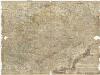
Neue und accurate Landkarte des Mittägig- Ober- Sächsischen R. Reichs- Creyß
1 : 700000 Bavorsko (Německo) Lidl, Johann Jakob Johann Jacob Lidl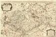
Le Cercle de la Haute Saxe
1 : 610000 Mollova mapová sbírka Sanson, Guillaume Jaillot, Alexis Hubert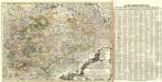
Neue und accurate Landkarte des Mittägig- Ober- Sächsischen K. Reichs- Creyß
1 : 675000 Mollova mapová sbírka Lidl, Johann Jakob Lidl, Johann Jacob
Saxoniae

Le Cercle De La Haute Saxe [...] [Karte], in: Atlas nouveau, contenant toutes les parties du monde [...], Bd. 1, S. 312.
1 Karte aus Atlas Sanson, Nicolas Jaillot, Alexis Hubert und Mortier, Pieter
Oro-hydro-graphische general Charte von Königreiche Sachsen und den angrenzenden Ländern
1 : 450000 Sasko (Německo) Rühle von Lilienstern, Johann Jakob Otto August Keyl, Christian Karl Maximilian in der Rittnerschen Kunsthandlung

Dvcatvs electorat[us] et principat[us] dvcvm Saxoniae
1 : 462500 Sasko (Německo) Zollmann, Friedrich Zollmann, Philipp Heinrich ab Homannianis Heredibvs
Carte de la Haute Saxe et de la Lusace
1 : 900000 Lužice (Německo) Mentelle, Edme Tardieu, Pierre François
Partie méridionale de cercle de la Haute Saxe
1 : 1740000 Sasko (Německo) Bonne, Rigobert André


Saxoniae, Misniae, Thuringiae, Nova Exactissimaque Descriptio. [Karte], in: Theatrum orbis terrarum, S. 127.
1 Karte aus Atlas Ortelius, Abraham
Circuli Saxoniae Superioris Tabula ad usum serenissimi Burgundiae Ducis Parissis
1 : 740000 Mollova mapová sbírka Jaillot, Alexis-Hubert Ottens, Josua
Circuli Saxoniae Superioris Tabula ad usum serenissimi Burgundiae Ducis Parissis
1 : 740000 Mollova mapová sbírka Jaillot, Alexis-Hubert Jaillot, Alexis Hubert
Circuli Supe. Saxoniae Pars Meridionalis sive Ducatus, Electoratus et Principatus Ducum Saxoniae
1 : 680000 Mollova mapová sbírka Zollmann, Friedrich Homann, Johann Baptista - dědici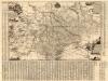
Neue Chur Saechsische Post Carte
1 : 330000 Mollova mapová sbírka Zürner, Adam Friedrich Bodenehr, Moritz
Feldzug von 1756
[Preuß. Generalstab]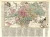
Aller Neueste Chur Saechsische Post Charte
1 : 340000 Mollova mapová sbírka Zürner, Adam Friedrich Lotter, Tobias Conrad
Sachsen die Staaten in Thüringen und benachbartex Länder

Parte del Circolo dell Alta Sassonia
1 : 750000 Mollova mapová sbírka Cantelli, Giacomo De Rossi, Giovanni Giacomo
Saxoniae, Misniae, Thvringiae, nova exactissimaq[ue] descriptio
1 Karte : Kupferdruck ; 31 x 47 cm Ortelius s.n.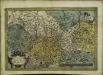
Saxoniae, Misniae, Thvringiae, nova exactissimaq[ue] descriptio
1 Karte : Kupferdruck ; 32 x 48 cm Ortelius s.n.
Circuli Supe. Saxoniae pars meridionalis sive ducatus, electoratus et principatus Ducum Saxoniae
1 Karte : Kupferdruck ; 46 x 54 cm Zürner; Zollmann Homännische Erben
Circuli Supe. Saxoniae pars meridionalis sive ducatus, electoratus et principatus Ducum Saxoniae
1 Karte : Kupferdruck ; 47 x 54 cm Zürner; Zollmann Homännische Erben
![Misniae Et Lusatiae Tabula [Karte], in: Theatrum orbis terrarum, S. 138.](https://images-0.georeferencer.com/images/iiif/649958871985/full/,300/0/native.jpg)

