Maps of Saxony
Neue Chur Saechsische Post Carte
1 : 330000 Mollova mapová sbírka Zürner, Adam Friedrich Bodenehr, Moritz
Saxoniae, Misniae, Thvringiae, nova exactissimaq[ue] descriptio
1 Karte : Kupferdruck ; 31 x 47 cm Ortelius s.n.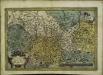
Saxoniae, Misniae, Thvringiae, nova exactissimaq[ue] descriptio
1 Karte : Kupferdruck ; 32 x 48 cm Ortelius s.n.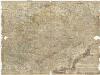
Neue und accurate Landkarte des Mittägig- Ober- Sächsischen R. Reichs- Creyß
1 : 700000 Bavorsko (Německo) Lidl, Johann Jakob Johann Jacob Lidl
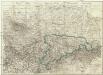
Circulus Saxoniae Superioris
1 : 480000 Mollova mapová sbírka Valk, Gerhard Valck, Gerard
Carte Itineraire par le Pays de l'Electorat de Saxe
1 : 800000 Mollova mapová sbírka Homann, Johann Baptist Homann, Johann Baptista - dědici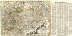
Neue und accurate Landkarte des Mittägig- Ober- Sächsischen K. Reichs- Creyß
1 : 675000 Mollova mapová sbírka Lidl, Johann Jakob Lidl, Johann Jacob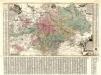
Aller Neueste Chur Saechsische Post Charte
1 : 340000 Mollova mapová sbírka Zürner, Adam Friedrich Lotter, Tobias Conrad
Misniae Et Lusatiae Tabula [Karte], in: Theatrum orbis terrarum, S. 138.
1 Karte aus Atlas Ortelius, Abraham
Misniae Et Lusatiae Tabula [Karte], in: Theatrum orbis terrarum, S. 230.
1 Karte aus Atlas Ortelius, Abraham Vrients, Jan Baptista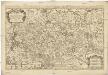
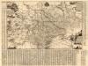
Le cercle de la Haute Saxe
1 : 593000 Braniborsko (Německo) Sanson, Nicolas Iean Cóvens et Corneille Mortier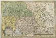
Saxoniae Misniae, Thvringiae, Nova Exactissimaque Descriptio
1 : 900000 Mollova mapová sbírka Ortelius, Abraham Plantin, Christoph
Saxoniae Electoralis, Finitimarumque Provinciarum Nova et Antea nunquam edita delineatio
1 : 730000 Mollova mapová sbírka Schenk, Pieter Schenk, Peter I
Carte de la Haute Saxe et de la Lusace
1 : 900000 Lužice (Německo) Mentelle, Edme Tardieu, Pierre François
Ducatus Saxoniae Superioris :
1 : 720000 Mollova mapová sbírka Zollmann, Friedrich Homann, Johann Baptista - dědici
Friderico Augusto vere Augusto Polon. Lithuan. Borus. Pomer. Regi, Duci, Principi, Saxon. Utr. Duci S. Imp. Elect. Haec. Imperii Sui Regna D.D.D.
1 : 3100000 Mollova mapová sbírka Schenk, Pieter Schenk, Peter I
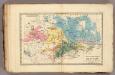
Hanc Regni Poloniarvm Magniqve Dvcatvs Lithvaniae Rvssiae, Prvssiae, Mazoviae, Samogitiae, Kioviae, Volhyniae, Podoliae, Podlachiae, Livoniae, Smolensci, Severia e. Czern.
1 : 3000000 Mollova mapová sbírka Homann, Johann Baptist Homann, Johann Baptista - dědici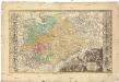
Dvcatvs electorat[us] et principat[us] dvcvm Saxoniae
1 : 462500 Sasko (Německo) Zollmann, Friedrich Zollmann, Philipp Heinrich ab Homannianis Heredibvs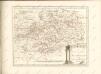
Saxe mineralogique.
1 : 1050000 Vincent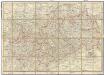
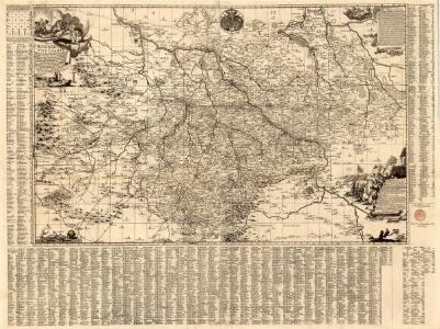
Post-Charte des Königreichs Sachsen und der angränzenden Länder
1 : 411000 Sasko (Německo) Güssefeld, Franz L. Keyl, C. im Geograph. Instituts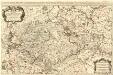
Le Cercle de la Haute Saxe
1 : 610000 Mollova mapová sbírka Sanson, Guillaume Jaillot, Alexis Hubert
Saxoniae superioris
1 : 500000 Sasko (Německo) Lotter, Tobias Conrad T.C. Lotter
Saxoniae superioris
1 : 500000 Sasko (Německo) Lotter, Tobias Conrad T. C. Lotter
Saxonia Svperior, Cvm Lvsatia et Misnia
1 : 780000 Mollova mapová sbírka Blaeu, Joan Blaeu, Joan I.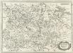
Ober Sachsen Laußnitz vnd Meissen
1 : 1200000 Mollova mapová sbírka Merian, Matthaeus Merian, Matthäus
Neue Karte des Kuhrfürstenthums [sic] Sachsen und sämtlicher incorporirter Lande, darinnen enthalten die VII. Kreise
Durynsko (Německo) Schenk, Pieter Petrus Schenk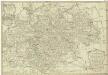
Neue Karte des Kuhrfürstenthums Sachsen und sämtlicher incorporirter Lande, darinnen enthalten die VII. Kreise
1 : 520000 Durynsko (Německo) Schenk, Pieter Petrus Schenk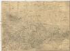
Oro- Hydro-Graphische General Charte vom Königreiche Sachsen und den angrenzenden Ländern
1 : 460000 Sasko (Německo) R. v. L. Bach, Joseph in der Rittnerschen Kunsthandlung