Maps of Saxony

Ducatus Saxoniae Superioris :
1 : 720000 Mollova mapová sbírka Zollmann, Friedrich Homann, Johann Baptista - dědici
Friderico Augusto vere Augusto Polon. Lithuan. Borus. Pomer. Regi, Duci, Principi, Saxon. Utr. Duci S. Imp. Elect. Haec. Imperii Sui Regna D.D.D.
1 : 3100000 Mollova mapová sbírka Schenk, Pieter Schenk, Peter I
Hanc Regni Poloniarvm Magniqve Dvcatvs Lithvaniae Rvssiae, Prvssiae, Mazoviae, Samogitiae, Kioviae, Volhyniae, Podoliae, Podlachiae, Livoniae, Smolensci, Severia e. Czern.
1 : 3000000 Mollova mapová sbírka Homann, Johann Baptist Homann, Johann Baptista - dědici
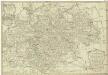
Saxoniae, Misniae, Thvringiae, nova exactissimaq[ue] descriptio
1 Karte : Kupferdruck ; 31 x 47 cm Ortelius s.n.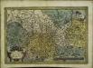
Saxoniae, Misniae, Thvringiae, nova exactissimaq[ue] descriptio
1 Karte : Kupferdruck ; 32 x 48 cm Ortelius s.n.
Saxonia Svperior, Cvm Lvsatia et Misnia
1 : 780000 Mollova mapová sbírka Blaeu, Joan Blaeu, Joan I.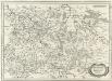
Ober Sachsen Laußnitz vnd Meissen
1 : 1200000 Mollova mapová sbírka Merian, Matthaeus Merian, Matthäus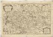
Le cercle de la Haute Saxe
1 : 593000 Braniborsko (Německo) Sanson, Nicolas Iean Cóvens et Corneille Mortier
Le Cercle De La Haute Saxe [...] [Karte], in: Atlas nouveau, contenant toutes les parties du monde [...], Bd. 1, S. 312.
1 Karte aus Atlas Sanson, Nicolas Jaillot, Alexis Hubert und Mortier, Pieter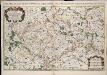
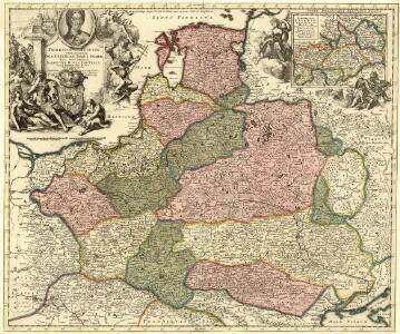
Le cercle de la Haute Saxe, ou sont compris le duché et eslectorat de Saxe les marquisats de Misnie, et de Lusace le landgraviat de Thuringe dans ce cercle sont encor compris le Brandebourg, et la Pomeranie qui font chacune leur carte separée / par le Sr. Sanson ... 1676
1 : 615000 Annotatie: Auec priuilege du Roy, pour vingt ans, 16..; Titel boven de kaart: Le cercle de la Haute Saxe ou sont le duché et eslectorat de Saxe, les marquisats de Misnie et de Lusace, et le landgraviat de Thuringe, qui comprennent les estats des ducs de Saxe, la principauté d'Anhalt, les comtés de Mansfeld, de Schwartzburg, de Stolberg, de Hohenstein, de Barby, et de Beichlingen ...; Origineel is Blad 97 in atlas factice; Annotatie geografische gegevens: Met 6 schaalstokken Guillaume Sanson 1633-1703 A Paris : chez H. Iaillot ...
Germany Central.
1 : 1100000 Hall, S. (Sidney)

Saxoniae Electoralis, Finitimarumque Provinciarum Nova et Antea nunquam edita delineatio
1 : 730000 Mollova mapová sbírka Schenk, Pieter Schenk, Peter I
Charte von dem Königreich Sachsen
1 : 690000 Sasko (Německo) Zuccheri, Edmund von Kunst und Industrie Comptoirs
Circulus Saxoniae Superioris
1 : 480000 Mollova mapová sbírka Valk, Gerhard Valck, Gerard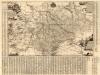
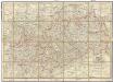
Neue Chur Saechsische Post Carte
1 : 330000 Mollova mapová sbírka Zürner, Adam Friedrich Bodenehr, Moritz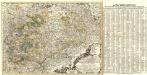
Neue und accurate Landkarte des Mittägig- Ober- Sächsischen K. Reichs- Creyß
1 : 675000 Mollova mapová sbírka Lidl, Johann Jakob Lidl, Johann Jacob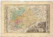
Dvcatvs electorat[us] et principat[us] dvcvm Saxoniae
1 : 462500 Sasko (Německo) Zollmann, Friedrich Zollmann, Philipp Heinrich ab Homannianis Heredibvs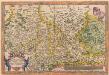
Saxoniae, Misniae, Thuringiae, Nova Exactissimaque Descriptio. [Karte], in: Theatrum orbis terrarum, S. 127.
1 Karte aus Atlas Ortelius, Abraham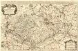
Le Cercle de la Haute Saxe
1 : 610000 Mollova mapová sbírka Sanson, Guillaume Jaillot, Alexis Hubert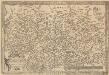
Saxoniae, Misniae, Thuringiae, Nova Exactissimaque Descriptio. [Karte], in: Theatrum orbis terrarum, S. 219.
1 Karte aus Atlas Ortelius, Abraham Vrients, Jan Baptista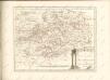
Post-Charte des Königreichs Sachsen und der angränzenden Länder
1 : 411000 Sasko (Německo) Güssefeld, Franz L. Keyl, C. im Geograph. Instituts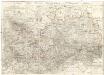
Oro-hydro-graphische general Charte von Königreiche Sachsen und den angrenzenden Ländern
1 : 450000 Sasko (Německo) Rühle von Lilienstern, Johann Jakob Otto August Keyl, Christian Karl Maximilian in der Rittnerschen Kunsthandlung
Das Königreich Sachsen mit den Kurfürstlich- und Herzoglich- Saechsischen Laendern / ... neu entw. von D.F. Sotzmann
1 : 600000 Sotzmann, Daniel Friedrich Nürnberg : Schneider u. Weigelschen Kunst u. Buchhandlung
Carte de la Haute Saxe et de la Lusace
1 : 900000 Lužice (Německo) Mentelle, Edme Tardieu, Pierre François
Saxoniae Misniae, Thvringiae, Nova Exactissimaque Descriptio
1 : 900000 Mollova mapová sbírka Ortelius, Abraham Plantin, Christoph
Aller Neueste Chur Saechsische Post Charte
1 : 340000 Mollova mapová sbírka Zürner, Adam Friedrich Lotter, Tobias Conrad
Saxe mineralogique.
1 : 1050000 Vincent
Neue Karte des Kuhrfürstenthums [sic] Sachsen und sämtlicher incorporirter Lande, darinnen enthalten die VII. Kreise
Durynsko (Německo) Schenk, Pieter Petrus Schenk