Maps of Saxony
Le Cercle de la Haute Saxe
1 : 610000 Mollova mapová sbírka Sanson, Guillaume Jaillot, Alexis Hubert
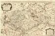
Le cercle de la Haute Saxe, ou sont compris le duché et eslectorat de Saxe les marquisats de Misnie, et de Lusace le landgraviat de Thuringe dans ce cercle sont encor compris le Brandebourg, et la Pomeranie qui font chacune leur carte separée / par le Sr. Sanson ... 1676
1 : 615000 Annotatie: Auec priuilege du Roy, pour vingt ans, 16..; Titel boven de kaart: Le cercle de la Haute Saxe ou sont le duché et eslectorat de Saxe, les marquisats de Misnie et de Lusace, et le landgraviat de Thuringe, qui comprennent les estats des ducs de Saxe, la principauté d'Anhalt, les comtés de Mansfeld, de Schwartzburg, de Stolberg, de Hohenstein, de Barby, et de Beichlingen ...; Origineel is Blad 97 in atlas factice; Annotatie geografische gegevens: Met 6 schaalstokken Guillaume Sanson 1633-1703 A Paris : chez H. Iaillot ...
Oro-hydro-graphische general Charte von Königreiche Sachsen und den angrenzenden Ländern
1 : 450000 Sasko (Německo) Rühle von Lilienstern, Johann Jakob Otto August Keyl, Christian Karl Maximilian in der Rittnerschen Kunsthandlung

Le Cercle De La Haute Saxe [...] [Karte], in: Atlas nouveau, contenant toutes les parties du monde [...], Bd. 1, S. 312.
1 Karte aus Atlas Sanson, Nicolas Jaillot, Alexis Hubert und Mortier, Pieter
Sachsen
Allgemeiner Atlas [Walch, Johannes] im Verlag bei Johannes Walch
Saxoniae, Misniae, Thuringiae, Nova Exactissimaque Descriptio. [Karte], in: Theatrum orbis terrarum, S. 61.
1 Karte aus Atlas Ortelius, Abraham
Neue und accurate Landkarte des Mittägig- Ober- Sächsischen K. Reichs- Creyß
1 : 675000 Mollova mapová sbírka Lidl, Johann Jakob Lidl, Johann Jacob
Saxoniae, Misniae, Thuringiae, Nova Exactissimaque Descriptio. [Karte], in: Theatrum orbis terrarum, S. 219.
1 Karte aus Atlas Ortelius, Abraham Vrients, Jan Baptista
Saxoniae, Misniae, Thuringiae, Nova Exactissimaque Descriptio. [Karte], in: Theatrum orbis terrarum, S. 127.
1 Karte aus Atlas Ortelius, Abraham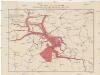
Karte über die Circulation der böhmischen Braunkohle während des Jahres 1870
Německo Pechar, Johann C.H. Hunger
Circuli Supe. Saxoniae Pars Meridionalis...
from Atlas minor. XXXI. tabvlarvm Homannianarvm coloribus methodice distinctarum.
Neue Karte des Kuhrfürstenthums [sic] Sachsen und sämtlicher incorporirter Lande, darinnen enthalten die VII. Kreise
Durynsko (Německo) Schenk, Pieter Petrus Schenk
Neue Karte des Kuhrfürstenthums Sachsen und sämtlicher incorporirter Lande, darinnen enthalten die VII. Kreise
1 : 520000 Durynsko (Německo) Schenk, Pieter Petrus Schenk
Saxoniae Electoralis, Finitimarumque Provinciarum Nova et Antea nunquam edita delineatio
1 : 730000 Mollova mapová sbírka Schenk, Pieter Schenk, Peter I
Sachsen, Thuringische Staaten.
1 : 870000 Andree, Richard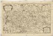
Le cercle de la Haute Saxe
1 : 593000 Braniborsko (Německo) Sanson, Nicolas Iean Cóvens et Corneille Mortier
Saxoniae

Das Königreich Sachsen mit den Kurfürstlich- und Herzoglich- Saechsischen Laendern / ... neu entw. von D.F. Sotzmann
1 : 600000 Sotzmann, Daniel Friedrich Nürnberg : Schneider u. Weigelschen Kunst u. Buchhandlung

Circuli Saxoniae Superioris Tabula ad usum serenissimi Burgundiae Ducis Parissis
1 : 740000 Mollova mapová sbírka Jaillot, Alexis-Hubert Ottens, Josua
Circuli Saxoniae Superioris Tabula ad usum serenissimi Burgundiae Ducis Parissis
1 : 740000 Mollova mapová sbírka Jaillot, Alexis-Hubert Jaillot, Alexis Hubert
Misniae Et Lusatiae Tabula [Karte], in: Theatrum orbis terrarum, S. 230.
1 Karte aus Atlas Ortelius, Abraham Vrients, Jan Baptista
Germany Central.
1 : 1100000 Hall, S. (Sidney)
Saxoniae, Misniae, Thvringiae, nova exactissimaq[ue] descriptio
1 Karte : Kupferdruck ; 31 x 47 cm Ortelius s.n.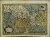
Saxoniae, Misniae, Thvringiae, nova exactissimaq[ue] descriptio
1 Karte : Kupferdruck ; 32 x 48 cm Ortelius s.n.
Das Königreich Sachen
Neuester Schul-Atlas Walch, Johann im Verlag bei Joh. Walch
Die Schlesischen Kriege
1 : 3000000 Mitteleuropa Schlesische Kriege
Misniae Et Lusatiae Tabula [Karte], in: Theatrum orbis terrarum, S. 138.
1 Karte aus Atlas Ortelius, Abraham


