Maps of Brandenburg


Sachsen
Allgemeiner Atlas [Walch, Johannes] im Verlag bei Johannes Walch
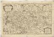
Saxoniae, Misniae, Thuringiae, Nova Exactissimaque Descriptio. [Karte], in: Theatrum orbis terrarum, S. 61.
1 Karte aus Atlas Ortelius, Abraham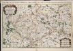
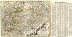
Le cercle de la Haute Saxe, ou sont compris le duché et eslectorat de Saxe les marquisats de Misnie, et de Lusace le landgraviat de Thuringe dans ce cercle sont encor compris le Brandebourg, et la Pomeranie qui font chacune leur carte separée / par le Sr. Sanson ... 1676
1 : 615000 Annotatie: Auec priuilege du Roy, pour vingt ans, 16..; Titel boven de kaart: Le cercle de la Haute Saxe ou sont le duché et eslectorat de Saxe, les marquisats de Misnie et de Lusace, et le landgraviat de Thuringe, qui comprennent les estats des ducs de Saxe, la principauté d'Anhalt, les comtés de Mansfeld, de Schwartzburg, de Stolberg, de Hohenstein, de Barby, et de Beichlingen ...; Origineel is Blad 97 in atlas factice; Annotatie geografische gegevens: Met 6 schaalstokken Guillaume Sanson 1633-1703 A Paris : chez H. Iaillot ...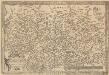
Saxoniae, Misniae, Thuringiae, Nova Exactissimaque Descriptio. [Karte], in: Theatrum orbis terrarum, S. 219.
1 Karte aus Atlas Ortelius, Abraham Vrients, Jan Baptista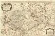
Le Cercle de la Haute Saxe
1 : 610000 Mollova mapová sbírka Sanson, Guillaume Jaillot, Alexis Hubert
Der Kriegsschauplatz im Norden
1 : 1712000 Frankfurt nad Mohanem (Německo) Neuen Freien Presse
Le Cercle De La Haute Saxe [...] [Karte], in: Atlas nouveau, contenant toutes les parties du monde [...], Bd. 1, S. 312.
1 Karte aus Atlas Sanson, Nicolas Jaillot, Alexis Hubert und Mortier, Pieter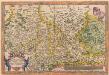
Saxoniae, Misniae, Thuringiae, Nova Exactissimaque Descriptio. [Karte], in: Theatrum orbis terrarum, S. 127.
1 Karte aus Atlas Ortelius, Abraham
Circuli Supe. Saxoniae Pars Meridionalis...
from Atlas minor. XXXI. tabvlarvm Homannianarvm coloribus methodice distinctarum.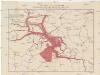
Karte über die Circulation der böhmischen Braunkohle während des Jahres 1870
Německo Pechar, Johann C.H. Hunger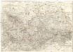
Oro-hydro-graphische general Charte von Königreiche Sachsen und den angrenzenden Ländern
1 : 450000 Sasko (Německo) Rühle von Lilienstern, Johann Jakob Otto August Keyl, Christian Karl Maximilian in der Rittnerschen Kunsthandlung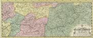
Albis Fluvius Germaniae celebris A Fontibus ad Ostia
1 : 880000 Mollova mapová sbírka Ottens, Joachim Ottens, Joachim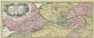
Albis Fluvius Germaniae celebris A Fontibus ad Ostia
1 : 880000 Mollova mapová sbírka Ottens, Joachim Ottens, Joachim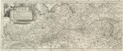
Eigentliche Vorstellung dess grossen Elb-Stroms in Deutschland, vom Ursprung biss zu seinen Ausfluss, mit seinen beyderseits einfliessenden Wassern und Flüssen
1 : 880000 Mollova mapová sbírka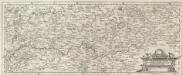
Eigentliche Vorstellung dess grossen Elb-Stroms in Deutschland, vom Ursprung biss zu seinen Ausfluss, mit seinen beyderseits einfliessenden Wassern und Flüssen
1 : 880000 Mollova mapová sbírka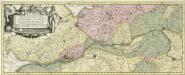
Albis Fluvius Germaniae celebris A Fontibus ad Ostia
1 : 860000 Mollova mapová sbírka Aveele, Johannes van den Schenk, Peter I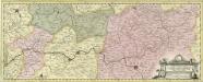
Albis Fluvius Germaniae celebris A Fontibus ad Ostia
1 : 860000 Mollova mapová sbírka Aveele, Johannes van den Schenk, Peter I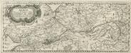
Albis Fluvius Germaniae celebris A Fontibus ad Ostia
1 : 880000 Mollova mapová sbírka Danckertsz, Cornelis Danckerts, Cornelis
Saxoniae

Prehľadná automapa NDR

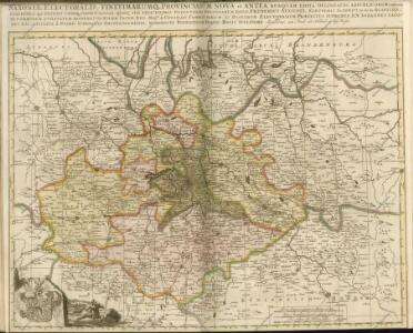
Saxoniae Electoralis, Finitimarumque Provinciarum Nova et Antea nunquam edita delineatio
1 : 730000 Mollova mapová sbírka Schenk, Pieter Schenk, Peter I
Soubor map
Charte von dem Königreich Sachsen
1 : 690000 Sasko (Německo) Zuccheri, Edmund von Kunst und Industrie Comptoirs
Neue Karte des Kuhrfürstenthums [sic] Sachsen und sämtlicher incorporirter Lande, darinnen enthalten die VII. Kreise
Durynsko (Německo) Schenk, Pieter Petrus Schenk
Neue Karte des Kuhrfürstenthums Sachsen und sämtlicher incorporirter Lande, darinnen enthalten die VII. Kreise
1 : 520000 Durynsko (Německo) Schenk, Pieter Petrus Schenk
Neue und accurate Landkarte des Mittägig- Ober- Sächsischen K. Reichs- Creyß
1 : 675000 Mollova mapová sbírka Lidl, Johann Jakob Lidl, Johann Jacob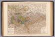
Sachsen, Thuringische Staaten.
1 : 870000 Andree, Richard