Maps of Saxony

Misniae Et Lusatiae Tabula [Karte], in: Theatrum orbis terrarum, S. 230.
1 Karte aus Atlas Ortelius, Abraham Vrients, Jan Baptista
Misniae Et Lusatiae Tabula [Karte], in: Theatrum orbis terrarum, S. 138.
1 Karte aus Atlas Ortelius, Abraham
Neue Karte des Kuhrfürstenthums [sic] Sachsen und sämtlicher incorporirter Lande, darinnen enthalten die VII. Kreise
Durynsko (Německo) Schenk, Pieter Petrus Schenk
Neue Karte des Kuhrfürstenthums Sachsen und sämtlicher incorporirter Lande, darinnen enthalten die VII. Kreise
1 : 520000 Durynsko (Německo) Schenk, Pieter Petrus Schenk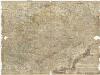
Neue und accurate Landkarte des Mittägig- Ober- Sächsischen R. Reichs- Creyß
1 : 700000 Bavorsko (Německo) Lidl, Johann Jakob Johann Jacob Lidl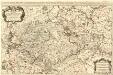
Le Cercle de la Haute Saxe
1 : 610000 Mollova mapová sbírka Sanson, Guillaume Jaillot, Alexis Hubert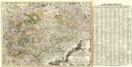
Neue und accurate Landkarte des Mittägig- Ober- Sächsischen K. Reichs- Creyß
1 : 675000 Mollova mapová sbírka Lidl, Johann Jakob Lidl, Johann Jacob
Saxoniae

Le Cercle De La Haute Saxe [...] [Karte], in: Atlas nouveau, contenant toutes les parties du monde [...], Bd. 1, S. 312.
1 Karte aus Atlas Sanson, Nicolas Jaillot, Alexis Hubert und Mortier, Pieter
Oro-hydro-graphische general Charte von Königreiche Sachsen und den angrenzenden Ländern
1 : 450000 Sasko (Německo) Rühle von Lilienstern, Johann Jakob Otto August Keyl, Christian Karl Maximilian in der Rittnerschen Kunsthandlung


Le cercle de la Haute Saxe, ou sont compris le duché et eslectorat de Saxe les marquisats de Misnie, et de Lusace le landgraviat de Thuringe dans ce cercle sont encor compris le Brandebourg, et la Pomeranie qui font chacune leur carte separée / par le Sr. Sanson ... 1676
1 : 615000 Annotatie: Auec priuilege du Roy, pour vingt ans, 16..; Titel boven de kaart: Le cercle de la Haute Saxe ou sont le duché et eslectorat de Saxe, les marquisats de Misnie et de Lusace, et le landgraviat de Thuringe, qui comprennent les estats des ducs de Saxe, la principauté d'Anhalt, les comtés de Mansfeld, de Schwartzburg, de Stolberg, de Hohenstein, de Barby, et de Beichlingen ...; Origineel is Blad 97 in atlas factice; Annotatie geografische gegevens: Met 6 schaalstokken Guillaume Sanson 1633-1703 A Paris : chez H. Iaillot ...
Dvcatvs electorat[us] et principat[us] dvcvm Saxoniae
1 : 462500 Sasko (Německo) Zollmann, Friedrich Zollmann, Philipp Heinrich ab Homannianis Heredibvs
Feldzug von 1756
[Preuß. Generalstab]
Carte de la Haute Saxe et de la Lusace
1 : 900000 Lužice (Německo) Mentelle, Edme Tardieu, Pierre François
Saxoniae, Misniae, Thuringiae, Nova Exactissimaque Descriptio. [Karte], in: Theatrum orbis terrarum, S. 219.
1 Karte aus Atlas Ortelius, Abraham Vrients, Jan Baptista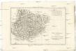
Partie méridionale de cercle de la Haute Saxe
1 : 1740000 Sasko (Německo) Bonne, Rigobert André

Saxoniae, Misniae, Thuringiae, Nova Exactissimaque Descriptio. [Karte], in: Theatrum orbis terrarum, S. 127.
1 Karte aus Atlas Ortelius, Abraham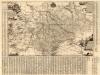
Neue Chur Saechsische Post Carte
1 : 330000 Mollova mapová sbírka Zürner, Adam Friedrich Bodenehr, Moritz
Circuli Saxoniae Superioris Tabula ad usum serenissimi Burgundiae Ducis Parissis
1 : 740000 Mollova mapová sbírka Jaillot, Alexis-Hubert Ottens, Josua
Circuli Saxoniae Superioris Tabula ad usum serenissimi Burgundiae Ducis Parissis
1 : 740000 Mollova mapová sbírka Jaillot, Alexis-Hubert Jaillot, Alexis Hubert
Circuli Supe. Saxoniae Pars Meridionalis sive Ducatus, Electoratus et Principatus Ducum Saxoniae
1 : 680000 Mollova mapová sbírka Zollmann, Friedrich Homann, Johann Baptista - dědici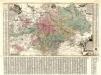
Aller Neueste Chur Saechsische Post Charte
1 : 340000 Mollova mapová sbírka Zürner, Adam Friedrich Lotter, Tobias Conrad
Operations-Karte, zum Feldzuge in Sachsen und Schlesien gehoerig

Das Königreich Sachen
Neuester Schul-Atlas Walch, Johann im Verlag bei Joh. Walch
Saxoniae, Misniae, Thvringiae, nova exactissimaq[ue] descriptio
1 Karte : Kupferdruck ; 31 x 47 cm Ortelius s.n.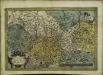
Saxoniae, Misniae, Thvringiae, nova exactissimaq[ue] descriptio
1 Karte : Kupferdruck ; 32 x 48 cm Ortelius s.n.
![Misniae Et Lusatiae Tabula [Karte], in: Theatrum orbis terrarum, S. 230.](https://images-0.georeferencer.com/images/iiif/547250576052/full/,300/0/native.jpg)

