Maps of Oberösterreich

Salisburgensis Iurisdictionis, locorumque vicinorum vera descriptio [Karte], in: Theatrum orbis terrarum, S. 168.
1 Karte aus Atlas Ortelius, Abraham
Salisburgensis Iurisdictionis, locorumque vicinorum vera descriptio [Karte], in: Theatrum orbis terrarum, S. 260.
1 Karte aus Atlas Ortelius, Abraham Vrients, Jan Baptista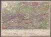
Geologische Uibersichts-Karte zur Reise von Wien durch Oesterreich, Salzburg, Kärnthen, Steyermark und Tyrol bis München, mit Berücksichtigung der österreichischen Alpen und des Bayer. Hochgebirgs
1 : 576000 Morlot, Adolph von Artaria & Co.
Salisburgensis Iurisdictionis, locorumque vicinorum vera descriptio [Karte], in: Theatrum orbis terrarum, S. 70.
1 Karte aus Atlas Ortelius, Abraham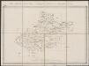
Saltzburg archiepiscopatus cum ducatu Carinthiae [Karte], in: Gerardi Mercatoris Atlas, sive, Cosmographicae meditationes de fabrica mundi et fabricati figura, S. 406.
1 Karte aus Atlas Mercator, Gerhard Montanus, Petrus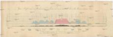
Alpen-Quer-Profil von der Mündung der Piave in das Adriatische Meer bis Braunau am Inn
Alpy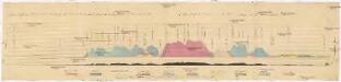
Quer-Profil der Alpen von der Mündung der Piave in das Adriatische Meer, über den Grossglockner, bis Braunau am Inn
Alpy Zeithammer, Antonín Otakar
Saltzburg Archiepiscopatus, et Carinthia Ducatus. [Karte], in: Novus Atlas, das ist, Weltbeschreibung, Bd. 1, S. 219.
1 Karte aus Atlas Blaeu, Joan Blaeu, Willem Janszoon
Saltzburg archiepiscopatus cum ducatu Carinthiae [Karte], in: Gerardi Mercatoris et I. Hondii Newer Atlas, oder, Grosses Weltbuch, Bd. 1, S. 337.
1 Karte aus Atlas Mercator, Gerhard und Hondius, Jodocus Jansson, Jan
VII, uit: General-Karte des oesterreichischen Kaiserstaates mit einem grossen Theile der angrenzenden Länder / durch Josef Scheda ... bearb. und hrsg
1 : 576000 Annotatie geografische gegevens: Maatstokken: oesterreichische Meilen, geografische oder deutsche Meilen, preussische Meilen, türkische Berri, französische Lieues, russische Werste; Maatstok per blad: wiener Klafter, öster. Meilen; Blad XIX: statistische en taalkundige informatie; Blad XIX: legenda [Wien : K.K. Militärisch-Geografisches Institut]
Evropa

[München-Linz-Bruck].
1 : 576000 Rakousko Blumtritt, H. Oesfeld, C. W.
Sheet VII: Karte Des Oesterreichischen Kaiserstaates.
1 : 576000 Scheda, Josef
Saltzburg Archiepiscopatus, et Carinthia Ducatus. [Karte], in: Theatrum orbis terrarum, sive, Atlas novus, Bd. 1, S. 274.
1 Karte aus Atlas Blaeu, Joan Blaeu, Willem Janszoon
SALTZBVRG ARCHIEPISCOPTVS, et CARINTHIA DVCATVS
Auct. Ger. Mercatore Amsterdami | Apud Guiljelmum Blaeu.

S. R. I. principat. et archiepiscopatus Salisburgensis mappa geographica
1 Karte : Kupferdruck ; 48 x 56 cm Seutter Matthäus Seutter
Saltzburg Archiepiscopatus, et Carinthia Ducatus [Karte], in: Novus atlas absolutissimus, Bd. 2, S. 279.
1 Karte aus Atlas Janssonius Offizin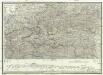
Strassen und Gebirgs-Karte zur Reise von Wien durch Oesterreich, Salzburg, Kärnthen, Steyermark und Tyrol bis München
1 : 576000 Alpy rakouské Schulz, R. A. Biller, Dominik Artaria & Co.
Saltzburg Archiepiscopatus, et Carinthia Ducatus. [Karte], in: Le théâtre du monde, ou, Nouvel atlas contenant les chartes et descriptions de tous les païs de la terre, Bd. 1, S. 248.
1 Karte aus Atlas Blaeu, Willem Janszoon und Blaeu, Joan Blaeu, Willem Janszoon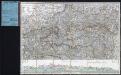
Strassen und Gebirgs-Karte zur Reise von Wien durch Österreich, Salzburg, Kärnthen, Steyermark und Tyrol bis München : mit Berücksichtigung der oesterreichischen Alpen und des Bayerischen Hochgebirgs
Artaria Co.
L'archeveché de Saltzbourg
1 Karte : Kupferdruck ; 48 x 55 cm Le Rouge Georges Louis Le Rouge rue des Grands Augustins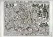
Provincia archiepiscopatus Salisburgensis
1 Karte : Kupferdruck ; 25 x 35 cm Gutwein; Hansiz M. Happach & F.X. Schlüter
S. R. I. principat. et archiepiscopatus Salisburgensis mappa geographica
1 Karte : Kupferdruck ; 48 x 56 cm Lotter Tobias Konrad Lotter

Laibach, Villach, Kufstein, Belluno
1 : 750000 Belluno (Itálie : provincie) Czerny, E. K. u. k. Militärgeographisches Institut
Laibach, Villach, Kufstein, Belluno
1 : 750000 Belluno (Itálie : provincie) K. k. militär-geographisches Institut
Letecká mapa Evropy

Charte von Salzburg, Passau, Aichstædt und Berchtesgaden
1 Karte : Kupferdruck ; 45 x 55 cm Kipferling Im Verlage des Kunst und Industrie Comptoirs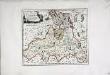
![Salisburgensis Iurisdictionis, locorumque vicinorum vera descriptio [Karte], in: Theatrum orbis terrarum, S. 168.](https://images-2.georeferencer.com/images/iiif/462891024860/full/,300/0/native.jpg)

