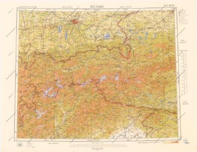
Maps of Tyrol

Letecká mapa Evropy

Karte der Schutzhäuser, Clubhütten, Alpenwirthshäuser und touristischen Stationen in den österreichischen und deutschen Alpenländern
1 : 1200000 Meurer, Julius Verlag Artaria & Co.
Evropa

Specielle Reise- und Gebirgs-Karte vom Lande Tyrol mit den angrenzenden Theilen von Südbayern, Salzburg, der Schweiz und Ober-Italien
1 : 500000 Bavorsko jižní (Německo) Mayr, Georg J. Palm'schen Hofbuchhandlung
Karte von Tyrol

Spezielle Reise- und Gebirgs-Karte vom Lande Tyrol mit den angrenzenden Theilen von Süd-Bayern, Salzburg, der Schweiz, (Graubünden) und Ober-Italien
Mayr, Johann Georg Grubert
Ch. Michel's Karte von Tyrol
1 : 600000 Tyrolsko (Rakousko) Michel, Ch. Jos. Ant. Finsterlin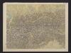
[R. Leuzinger's Relief-Karte von Tyrol, Südbayern & Salzburg nebst den angrenzenden Gebieten]
1 : 500000 Leuzinger, Rudolf Druck von Wurster, Randegger & Cie.
R. Leuzinger's Relief-Karte von Tyrol, Südbayern & Salzburg nebst den angrenzenden Gebieten
1 : 500000 Leuzinger, Rudolf Druck von Wurster, Randegger & Cie.
Laibach, Villach, Kufstein, Belluno
1 : 750000 Belluno (Itálie : provincie) Czerny, E. K. u. k. Militärgeographisches Institut
Laibach, Villach, Kufstein, Belluno
1 : 750000 Belluno (Itálie : provincie) K. k. militär-geographisches Institut
Principali Dignitate Comitatus Tirolis
1 : 1250000 Mollova mapová sbírka Weigel, Christoph Weigel, Christoph I.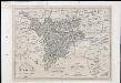
Karte von Tirol

Karte von Tirol
1 : 1175000 Tyrolsko jižní (Itálie a Rakousko)
Reisekarte von Tyrol
1 : 1000000 Benátsko (Itálie) Winckelmann, E. C. Hoffmannsche Verlagshandlung
Rhetiae alpestris descriptio, in qua hodie Tirolis Comitatus. [Karte], in: Theatrum orbis terrarum, S. 280.
1 Karte aus Atlas Ortelius, Abraham Vrients, Jan Baptista
Karte der gefürsteten Grafschaft Tyrol mit Vorarlberg : typographisch ausgeführt in der ersten k.k. a. p. Kunstdruckerei
Raffelsperger, Franz Typograph. Landkartenverlag
Rhetiae alpestris descriptio, in qua hodie Tirolis Comitatus. [Karte], in: Theatrum orbis terrarum, S. 185.
1 Karte aus Atlas Ortelius, Abraham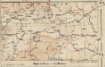
Alpenbahnen und -Pässe
1 : 2000000 Alpenländer Eisenbahnnetz, Pass
Tirolis comitatus continens episcop. Tridentinum et Brixiensem
1 : 570000 Brixen (Itálie) Lotter, Tobias Conrad sumtibus Tobiae Conradi Lotter
Tirolis comitatus continens episcop. Tridentinum et Brixiensem nec non comit. Brigantinum, Feldkirch, Sonneberg et Pludentin mappa geographica novissime et exactissime exarata
1 : 570000 Bludenz-oblast (Rakousko) Lotter, Tobias Conrad sumtibus Tobiae Conradi Lotter
Karte der gefürsteten Grafschaft Tirol nebst Vorarlberg
1 : 432000 Tyrolsko (Rakousko) Steinhauser, Anton Knorr, B. Artaria
Neueste special Karte des Bruker Kreises im Herzogthume Steyermark
1 : 220000 Bruck an der Mur (Rakousko) Kaiser, Joseph Franz Jos. Fr. Kaiser
Neueste special Karte des Bruker Kreises im Herzogthume Steyermark
1 : 210000 Bruck an der Mur (Rakousko) Kaiser, Jos. Fr. Jos. Fr. Kaiser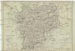
Carte von Tyrol nach den besten Hülfsmitteln verfasst
1 : 770000 Tyrolsko (Rakousko) Tranq. Mollo
Salisburgensis Iurisdictionis, locorumque vicinorum vera descriptio [Karte], in: Theatrum orbis terrarum, S. 260.
1 Karte aus Atlas Ortelius, Abraham Vrients, Jan Baptista
Salisburgensis Iurisdictionis, locorumque vicinorum vera descriptio [Karte], in: Theatrum orbis terrarum, S. 168.
1 Karte aus Atlas Ortelius, Abraham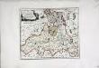
Das Erzstift Salzburg mit der gefürsteten Probstey Berchtesgaden
1 Karte : Kupferdruck ; 23 x 27 cm Reilly F. J. J. von Reilly