Maps of Oberösterreich

Salisburgensis Iurisdictionis, locorumque vicinorum vera descriptio [Karte], in: Theatrum orbis terrarum, S. 260.
1 Karte aus Atlas Ortelius, Abraham Vrients, Jan Baptista
Salisburgensis Iurisdictionis, locorumque vicinorum vera descriptio [Karte], in: Theatrum orbis terrarum, S. 168.
1 Karte aus Atlas Ortelius, Abraham
Salisburgensis Iurisdictionis, locorumque vicinorum vera descriptio [Karte], in: Theatrum orbis terrarum, S. 70.
1 Karte aus Atlas Ortelius, Abraham
Saltzburg Archiepiscopatus, et Carinthia Ducatus. [Karte], in: Novus Atlas, das ist, Weltbeschreibung, Bd. 1, S. 219.
1 Karte aus Atlas Blaeu, Joan Blaeu, Willem Janszoon
Saltzburg archiepiscopatus cum ducatu Carinthiae [Karte], in: Gerardi Mercatoris et I. Hondii Newer Atlas, oder, Grosses Weltbuch, Bd. 1, S. 337.
1 Karte aus Atlas Mercator, Gerhard und Hondius, Jodocus Jansson, Jan
Saltzburg Archiepiscopatus, et Carinthia Ducatus. [Karte], in: Theatrum orbis terrarum, sive, Atlas novus, Bd. 1, S. 274.
1 Karte aus Atlas Blaeu, Joan Blaeu, Willem Janszoon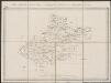
Saltzburg archiepiscopatus cum ducatu Carinthiae [Karte], in: Gerardi Mercatoris Atlas, sive, Cosmographicae meditationes de fabrica mundi et fabricati figura, S. 406.
1 Karte aus Atlas Mercator, Gerhard Montanus, Petrus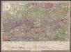
Geologische Uibersichts-Karte zur Reise von Wien durch Oesterreich, Salzburg, Kärnthen, Steyermark und Tyrol bis München, mit Berücksichtigung der österreichischen Alpen und des Bayer. Hochgebirgs
1 : 576000 Morlot, Adolph von Artaria & Co.

SALTZBVRG ARCHIEPISCOPTVS, et CARINTHIA DVCATVS
Auct. Ger. Mercatore Amsterdami | Apud Guiljelmum Blaeu.
[München-Linz-Bruck].
1 : 576000 Rakousko Blumtritt, H. Oesfeld, C. W.
Saltzburg Archiepiscopatus, et Carinthia Ducatus [Karte], in: Novus atlas absolutissimus, Bd. 2, S. 279.
1 Karte aus Atlas Janssonius Offizin
Saltzburg Archiepiscopatus, et Carinthia Ducatus. [Karte], in: Le théâtre du monde, ou, Nouvel atlas contenant les chartes et descriptions de tous les païs de la terre, Bd. 1, S. 248.
1 Karte aus Atlas Blaeu, Willem Janszoon und Blaeu, Joan Blaeu, Willem Janszoon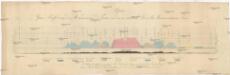
Alpen-Quer-Profil von der Mündung der Piave in das Adriatische Meer bis Braunau am Inn
Alpy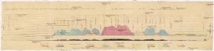
Quer-Profil der Alpen von der Mündung der Piave in das Adriatische Meer, über den Grossglockner, bis Braunau am Inn
Alpy Zeithammer, Antonín Otakar
S. R. I. principat. et archiepiscopatus Salisburgensis mappa geographica
1 Karte : Kupferdruck ; 48 x 56 cm Seutter Matthäus Seutter
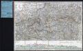
VII, uit: General-Karte des oesterreichischen Kaiserstaates mit einem grossen Theile der angrenzenden Länder / durch Josef Scheda ... bearb. und hrsg
1 : 576000 Annotatie geografische gegevens: Maatstokken: oesterreichische Meilen, geografische oder deutsche Meilen, preussische Meilen, türkische Berri, französische Lieues, russische Werste; Maatstok per blad: wiener Klafter, öster. Meilen; Blad XIX: statistische en taalkundige informatie; Blad XIX: legenda [Wien : K.K. Militärisch-Geografisches Institut]
Sheet VII: Karte Des Oesterreichischen Kaiserstaates.
1 : 576000 Scheda, Josef
L'archeveché de Saltzbourg
1 Karte : Kupferdruck ; 48 x 55 cm Le Rouge Georges Louis Le Rouge rue des Grands Augustins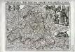
Provincia archiepiscopatus Salisburgensis
1 Karte : Kupferdruck ; 25 x 35 cm Gutwein; Hansiz M. Happach & F.X. Schlüter
S. R. I. principat. et archiepiscopatus Salisburgensis mappa geographica
1 Karte : Kupferdruck ; 48 x 56 cm Lotter Tobias Konrad Lotter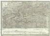
Strassen und Gebirgs-Karte zur Reise von Wien durch Oesterreich, Salzburg, Kärnthen, Steyermark und Tyrol bis München
1 : 576000 Alpy rakouské Schulz, R. A. Biller, Dominik Artaria & Co.
Strassen und Gebirgs-Karte zur Reise von Wien durch Österreich, Salzburg, Kärnthen, Steyermark und Tyrol bis München : mit Berücksichtigung der oesterreichischen Alpen und des Bayerischen Hochgebirgs
Artaria Co.
Letecká mapa Evropy

Laibach, Villach, Kufstein, Belluno
1 : 750000 Belluno (Itálie : provincie) Czerny, E. K. u. k. Militärgeographisches Institut
Laibach, Villach, Kufstein, Belluno
1 : 750000 Belluno (Itálie : provincie) K. k. militär-geographisches Institut
S. R. I. principatvs et archiepiscopatus Salisburgensis
1 Karte : Kupferdruck ; 47 x 57 cm Guetrather; Homann Johann Baptist Homann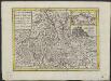
t'Aartsbisdom Saltzburg
1 : 1000000 gelegen na de stelling van de Hr. G. de l'Isle Deventer [etc.] : [by J. de Lat [etc.]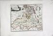
![Salisburgensis Iurisdictionis, locorumque vicinorum vera descriptio [Karte], in: Theatrum orbis terrarum, S. 260.](https://images-2.georeferencer.com/images/iiif/828210386711/full/,300/0/native.jpg)

