Maps of India

Erythraei Sive Rubri Maris Periplus [Karte] Annonis Periplus., [Polus Arcticus], Ulyssis Errores [3 Nebenkarten], in: Theatrum orbis terrarum, S. 535.
1 Karte aus Atlas Ortelius, Abraham Vrients, Jan Baptista
Asia Antiqua cum finitimis Africae et Europae Regionibus. [Karte], in: Novus atlas absolutissimus, Bd. 10, S. 27.
1 Karte aus Atlas Janssonius Offizin
Tabula Moderna Indiae [Karte], in: Claudii Ptolemei viri Alexandrini mathematice discipline philosophi doctissimi geographie opus [...], S. 275.
1 Karte aus Atlas Waldseemüller, Martin [und Ptolemaeus, Claudius] Übelin, Georg
104. Asia (Outside the USSR) Communications. The World Atlas.
1 : 30000000 USSR (Union of Soviet Socialist Republics).
Neueste Karte von Asien
Grosser Hand-Atlas über alle Theile der Erde in 170 Karten Meyer, J. Verlag des Bibliographischen Instituts
Charte von [Europa, Asien und Afrika]
Afrika Baumgarten, Siegmund Jakob Johann Justinus Gebauer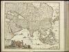
[4][4] Accuratissima totius Asiae tabula, uit: Atlas sive Descriptio terrarum orbis
Annotatie: Gedigitaliseerde versie. Amsterdam. Heiloo : Picturae (vervaardiger), 2015. tiff-bestand. Gedigitaliseerd: 07-01-2015; Origineel: Universiteitsbibliotheek Vrije Universiteit (XL.05127.-) ; Netherlands; Titelpagina ontbreekt Wit, Frederik de Amsterdam : Frederick de Wit

Asia accuratissime descripta
1 : 19000000 ex omnibus, quae hactenus extiterunt, imprimis viri ampliss. Nicolai Witsen, consulis Amstelaedamensis exactissimis delineatiobus Amst. : P. Schenk ex
Asiae recens summa cura delineata [Karte], in: Gerardi Mercatoris et I. Hondii Newer Atlas, oder, Grosses Weltbuch, Bd. 1, S. 36.
1 Karte aus Atlas Mercator, Gerhard und Hondius, Jodocus Jansson, Jan
Asiae Nova Descriptio. [Karte], in: Theatrum orbis terrarum, S. 55.
1 Karte aus Atlas Ortelius, Abraham Vrients, Jan Baptista
Asia wie es jetziger zeit nach den fuernemesten Herrschafften abgetheilet und beschriben ist
1 : 22000000 1 Karte : Holzschnitt ; 30 x 36 cm Münster, Sebastian [Sebastian Henricpetri]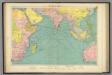
Indian Ocean.
1 : 20000000 Philip, George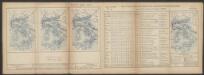
India Extrema XXIIII. Nova Tabula. [Karte], in: Claud. Ptolemaeus. Geographia lat. cum mappis [...], S. 434.
1 Karte aus Atlas Münster, Sebastian [und Ptolemaeus, Claudius]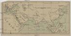
[Jižní Asie, Severovýchodní Afrika a Blízký východ]
Afrika severovýchodní Inf.-osv. odbor čsl. vojska na Rusi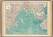
Indian Ocean.
1 : 25000000 John Bartholomew & Co.
L'Asie / par N. Sanson, geographe ord.re du roy
1 : 22000000 1 Karte : Kupferdruck ; 40 x 55 cm Sanson, Guillaume chez l'autheur au galleries du Louvre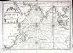
Carte de l'ocean oriental ou mer des Indes
1 Karte : Kupferdruck ; 33 x 47 cm Bellin Arkstée et Merkus
Asiae Nova Descriptio. [Karte], in: Theatrum orbis terrarum, S. 18.
1 Karte aus Atlas Ortelius, Abraham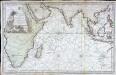
Carte reduite de l ocean oriental ou mer des Indes
1 Karte : Kupferdruck ; 52 x 84 cm Bellin s.n.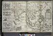
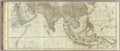
A map of the East-Indies and the adjacent countries ; with the settlements, factories and territories explaning what belongs to England, Spain, France, Holland, Denmark, Portugal &c. ...
from The world described, or, A new and correct sett of maps : shewing the kingdoms and states in all the known parts of the earth, with the principal cities, and most considerable towns in the world ... / ... by Herman Moll, geographer ...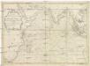
Carte de l'Ocean oriental ou Mer des Indes
1 : 7300000 Indický oceán-oblast Bellin, Jacques-Nicolas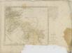
(Asia and its islands according to d'Anville. Southern section)
1 : 11100000 Kitchin, Thomas
India, or the Mogul's Empire.
from New & accurate description of the earth in all its empires, kingdoms and states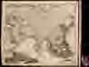
Exactissima Asiae delineatio
1 : 22000000 1 Karte : Kupferdruck ; 48 x 56 cm Danckerts,Theodorus [Danckerts]
Asien
Volksschul-Atlas über alle Teile der Erde Lange, Henry Druck und Verlag von Georg Westermann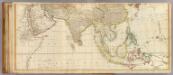
Asia (middle)
1 : 11000000 Anville, Jean Baptiste Bourguignon d, 1697-1782; Kitchin, Thomas; Robert Laurie & James Whittle
Asia vetvs / per Christoph: Weigelium
1 : 23000000 1 Karte : Kupferdruck ; 32 x 40 cm [Christoph Weigel]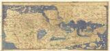
![Erythraei Sive Rubri Maris Periplus [Karte] Annonis Periplus., [Polus Arcticus], Ulyssis Errores [3 Nebenkarten], in: Theatrum orbis terrarum, S. 535.](https://images-2.georeferencer.com/images/iiif/626843921073/full/,300/0/native.jpg)

