Maps of China
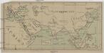
[Jižní Asie, Severovýchodní Afrika a Blízký východ]
Afrika severovýchodní Inf.-osv. odbor čsl. vojska na Rusi
Asia wie es jetziger zeit nach den fuernemesten Herrschafften abgetheilet und beschriben ist
1 : 22000000 1 Karte : Holzschnitt ; 30 x 36 cm Münster, Sebastian [Sebastian Henricpetri]
Asiae Nova Descriptio. [Karte], in: Theatrum orbis terrarum, S. 18.
1 Karte aus Atlas Ortelius, Abraham
[Historisch-geographischer Atlas zu den allgemeinen Geschichtswerken von C. v. Rotteck, Pölitz u. Becker] : Asien zur Zeit der grossen Mongholen Reiche
von Julius Loewenberg [Freiburg im Breisgau] : [Herder]
Asiae recens summa cura delineata [Karte], in: Gerardi Mercatoris et I. Hondii Newer Atlas, oder, Grosses Weltbuch, Bd. 1, S. 36.
1 Karte aus Atlas Mercator, Gerhard und Hondius, Jodocus Jansson, Jan
L'Asie / par N. Sanson, geographe ord.re du roy
1 : 22000000 1 Karte : Kupferdruck ; 40 x 55 cm Sanson, Guillaume chez l'autheur au galleries du Louvre
Asia [...] [Karte], in: Atlas, sive, Cosmographicae meditationes de fabrica mundi et fabricati figura, S. 71.
1 Karte aus Atlas Mercator, Gerhard
Asia [Karte], in: Gerardi Mercatoris Atlas, sive, Cosmographicae meditationes de fabrica mundi et fabricati figura, S. 70.
1 Karte aus Atlas Mercator, Gerhard Montanus, Petrus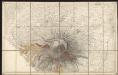
Asiae Nova Descriptio [Karte], in: Gerardi Mercatoris Atlas, sive, Cosmographicae meditationes de fabrica mundi et fabricati figura, S. 511.
1 Karte aus Atlas Mercator, Gerhard Montanus, Petrus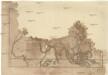
Charte von [Europa, Asien und Afrika]
Afrika Baumgarten, Siegmund Jakob Johann Justinus Gebauer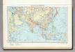
104. Asia (Outside the USSR) Communications. The World Atlas.
1 : 30000000 USSR (Union of Soviet Socialist Republics).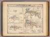
Orbis terrarum.
Menke, Th.


Asia accuratissime descripta
1 : 19000000 ex omnibus, quae hactenus extiterunt, imprimis viri ampliss. Nicolai Witsen, consulis Amstelaedamensis exactissimis delineatiobus Amst. : P. Schenk ex
Karte von Asien
1 : 2600000 Asie Friedl, F. Artaria
Orbis terrarum altero p. Chr. saeculo antiquis notus.
1 : 33000000 Kiepert, Heinrich, 1818-1899
Nieuwe kaart van Asia volgens de laatste ontdekkingen
1 : 60000000 [S.l.] : [s.n.]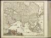
[4][4] Accuratissima totius Asiae tabula, uit: Atlas sive Descriptio terrarum orbis
Annotatie: Gedigitaliseerde versie. Amsterdam. Heiloo : Picturae (vervaardiger), 2015. tiff-bestand. Gedigitaliseerd: 07-01-2015; Origineel: Universiteitsbibliotheek Vrije Universiteit (XL.05127.-) ; Netherlands; Titelpagina ontbreekt Wit, Frederik de Amsterdam : Frederick de Wit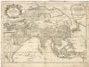
L'Asie
1 : 23380000 Asie Sanson, Guillaume Cordier, Louis chez H. Iaillot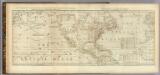
Chart containing the Coasts of California, New Albion, and Russian Discoveries to the North.
1 : 21000000 Jefferys, Thomas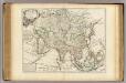
L'Asie.
1 : 43000000 L'Isle, Guillaume de, 1675-1726
Tabula Moderna Indiae [Karte], in: Claudii Ptolemei viri Alexandrini mathematice discipline philosophi doctissimi geographie opus [...], S. 275.
1 Karte aus Atlas Waldseemüller, Martin [und Ptolemaeus, Claudius] Übelin, Georg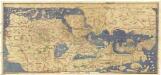
Charta rogeriana
Afrika Al-Idrísí Miller, Konrad Konrad Miller
Asien
Volksschul-Atlas über alle Teile der Erde Lange, Henry Druck und Verlag von Georg Westermann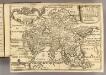
L'Asie.
1 : 44000000 Fer, Nicolas de, 1646-1720
Asia Antiqua cum finitimis Africae et Europae Regionibus. [Karte], in: Novus atlas absolutissimus, Bd. 10, S. 27.
1 Karte aus Atlas Janssonius Offizin
Exactissima Asiae delineatio
1 : 22000000 1 Karte : Kupferdruck ; 48 x 56 cm Danckerts,Theodorus [Danckerts]
Asia vetvs / per Christoph: Weigelium
1 : 23000000 1 Karte : Kupferdruck ; 32 x 40 cm [Christoph Weigel]
![[Jižní Asie, Severovýchodní Afrika a Blízký východ]](https://images-2.georeferencer.com/images/iiif/984341535833/full/,300/0/native.jpg)

