Maps of Indian Ocean
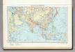
Indian Ocean.
1 : 20000000 Philip, George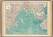
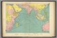
Indian Ocean.
1 : 25000000 John Bartholomew & Co.
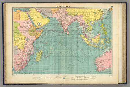
Meteorological chart of the Indian Ocean
1 : 22500000 Indický oceán (oblast) Secretary of Agriculture
Meteorological chart of the Indian Ocean
1 : 22500000 Indický oceán (oblast) Secretary of Agriculture
Meteorological chart of the Indian Ocean
1 : 22500000 Indický oceán (oblast) Secretary of Agriculture
Meteorological chart of the Indian Ocean
1 : 22500000 Indický oceán (oblast) Secretary of Agriculture
Meteorological chart of the Indian Ocean
1 : 22500000 Indický oceán (oblast) Secretary of Agriculture
Meteorological chart of the Indian Ocean
1 : 22500000 Indický oceán (oblast) Secretary of Agriculture
Indian Ocean
1 : 20000000 Austrálie National Geographic Society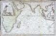
Carte reduite de l ocean oriental ou mer des Indes
1 Karte : Kupferdruck ; 52 x 84 cm Bellin s.n.
Indian Ocean cables, wireless stations.
1 : 40000000 Philip, George
Physikalische Karte vom Indischen Meere
Erster Band, enthaltend in vier Abtheilungen die Erscheinungen der anorganischen Natur: 1. Meteorologie und Klimatographie. 2. Hydrologie und Hydrographie. 3. Geologie. 4. Tellurischer Magnetismus Humboldt, Alexander von Verlag von Justus Perthes
Mar di India [Karte], in: Het vijfde Deel Des Grooten Atlas : Vervatende De Water-Weereld, S. 82.
1 Karte aus Atlas Jansson, Jan Jansson, Jan
Mare di India [Karte], in: Novus atlas absolutissimus, Bd. 9, S. 98.
1 Karte aus Atlas Janssonius Offizin
Physical Chart of the Indian Ocean
The physical atlas Johnston, Alexander Keith William Blackwood & Sons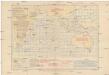
Pilot chart of the Indian Ocean
1 : 18000000 Indický oceán (oblast) Maury, Matthew Fontaine Hydrographic Office
Pilot chart of the Indian Ocean
1 : 18000000 Indický oceán (oblast) Maury, Matthew Fontaine Hydrographic Office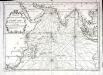
Carte de l'ocean oriental ou mer des Indes
1 Karte : Kupferdruck ; 33 x 47 cm Bellin Arkstée et Merkus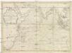
Carte de l'Ocean oriental ou Mer des Indes
1 : 7300000 Indický oceán-oblast Bellin, Jacques-Nicolas
Indischer Ozean
1 : 30000000 Indický oceán Institut für Meereskunde
(World, gnomonic proj. IV. Asia)
1 : 5000000 Society for the Diffusion of Useful Knowledge (Great Britain)
Tartariae sinensis mappa geographica

[Kaart], uit: Australien
1 : 10000000 Braunschweig [etc.] : Westermann
India Extrema XXIIII. Nova Tabula. [Karte], in: Claud. Ptolemaeus. Geographia lat. cum mappis [...], S. 434.
1 Karte aus Atlas Münster, Sebastian [und Ptolemaeus, Claudius]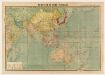
標準大東亜分圖. 共荣圈全圖
1 : 27800000 標準大東亞分圖‧共荣圈全圖 昭和十八年[1943]7月25日再版,芹澤馨吾 製圖,东京:統政社株式會社 發行 此图演示日本大东亚共荣圈的空间范围,包含亚洲、大洋洲、太平洋和印度洋的广大地区。 1图,彩色,日文,图幅54.5 x 77.3 cm,比例尺1:27,800,000,经纬度约为E30°-W160°; S45°-N60°。 Harvard-YenchingManchuguo J-0831;Hollis Number:014623995 芹澤馨吾 統政社株式會社
Erythraei Sive Rubri Maris Periplus [Karte] Annonis Periplus., [Polus Arcticus], Ulyssis Errores [3 Nebenkarten], in: Theatrum orbis terrarum, S. 535.
1 Karte aus Atlas Ortelius, Abraham Vrients, Jan Baptista
Asia Antiqua cum finitimis Africae et Europae Regionibus. [Karte], in: Novus atlas absolutissimus, Bd. 10, S. 27.
1 Karte aus Atlas Janssonius Offizin
Tabula Moderna Indiae [Karte], in: Claudii Ptolemei viri Alexandrini mathematice discipline philosophi doctissimi geographie opus [...], S. 275.
1 Karte aus Atlas Waldseemüller, Martin [und Ptolemaeus, Claudius] Übelin, Georg
[138][141] Occidentalior Tractus Indiarum Orientalium ..., uit: Atlas sive Descriptio terrarum orbis
Annotatie: Gedigitaliseerde versie. Amsterdam. Heiloo : Picturae (vervaardiger), 2015. tiff-bestand. Gedigitaliseerd: 07-01-2015; Origineel: Universiteitsbibliotheek Vrije Universiteit (XL.05127.-) ; Netherlands; Titelpagina ontbreekt Wit, Frederik de Amsterdam : Frederick de Wit