Maps of China
India Extrema XXIIII. Nova Tabula. [Karte], in: Claud. Ptolemaeus. Geographia lat. cum mappis [...], S. 434.
1 Karte aus Atlas Münster, Sebastian [und Ptolemaeus, Claudius]
Tartariae sinensis mappa geographica
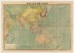
標準大東亜分圖. 共荣圈全圖
1 : 27800000 標準大東亞分圖‧共荣圈全圖 昭和十八年[1943]7月25日再版,芹澤馨吾 製圖,东京:統政社株式會社 發行 此图演示日本大东亚共荣圈的空间范围,包含亚洲、大洋洲、太平洋和印度洋的广大地区。 1图,彩色,日文,图幅54.5 x 77.3 cm,比例尺1:27,800,000,经纬度约为E30°-W160°; S45°-N60°。 Harvard-YenchingManchuguo J-0831;Hollis Number:014623995 芹澤馨吾 統政社株式會社
Asiae Nova Delineatio [Karte], in: Novus atlas absolutissimus, Bd. 6, S. 88.
1 Karte aus Atlas Janssonius Offizin
Asia
Handatlas über alle Theile der Erde und über das Weltgebäude Stieler, Adolf Justus Perthes
India Extrema; XIX. Nova Tabula. [Karte], in: Geographia universalis vetus et nova complectens Claudii Ptolemaei Alexandrini enarrationis libros VIII, S. 353.
1 Karte aus Atlas Münster, Sebastian [und Ptolemaeus, Claudius]
[Kaart], uit: Asien : politisch-wirtschaftlich
1 : 12000000 Bern : Kümmerly & Frey
Asien nach den neuesten Untersuchungen und Reiseberichten
Historisch-genealogisch-geographischer Atlas von Le Sage Las Cases, Emmanuel Auguste Dieudonné Marius Joseph de Johann Velten, Kunsthändler
Asien
1 : 21600000 entworfen und gezeichnet von C.F. Weiland Weimar : im Verlage des Geograph. Instituts
Map of the European settlements in the East Indies and on the eastern coast of Africa including part of Europe
1 : 33000000
Asia Antiqua cum finitimis Africae et Europae Regionibus. [Karte], in: Novus atlas absolutissimus, Bd. 10, S. 27.
1 Karte aus Atlas Janssonius Offizin
Generalis totius Imperii Moscovitici : novissima tabula magnam orbis terrarum partem a Polo Arctico usq[ue] ad mare Iaponicum, et Chine septentrionalis confinia exhibens cum via Czaricae nuper legationis ex urbe Moscua per universam Tartariam ad magnu[m] Chinae Imperatorem
1 : 13000000 Homann, Johann Baptist, 1663-1724 [I.B. Homann]
[Neuer Atlas der ganzen Erde nach den neuesten Bestimmungen ... : III.] Asien
Entworfen und gezeichnet von F.W. Streit H. Leutemann sc. Leipzig : J.C. Hinrichs'sche Buchhandlung
Neueste Karte von Asien
Grosser Hand-Atlas über alle Theile der Erde in 170 Karten Meyer, J. Verlag des Bibliographischen Instituts
Asien
1 : 20550000 entworfen und gezeichnet von C. F. Weiland gest. v. C. J. Mädel sen. Weimar : Verlag des Geograph. Instituts
Asiae Nova Descriptio. [Karte], in: Theatrum orbis terrarum, S. 55.
1 Karte aus Atlas Ortelius, Abraham Vrients, Jan Baptista
Accuratissima totius Asiae tabula in omnes partes divisa
1 : 25330000 de novo correcta, ac in lucem edita per Fredericum de Witt Amstelodami : ex officina J. Cóvens et C. Mortier
[Historisch-geographischer Atlas zu den allgemeinen Geschichtswerken von C. v. Rotteck, Pölitz u. Becker] : Asien zur Uebersicht des neuesten Zustandes und der wichtigsten geographische Entdeckungen
von Julius Loewenberg [Freiburg im Breisgau] : [Herder]
Asien
Atlas der Pflanzengeographie über alle Theile der Erde Rudolphi, Ludwig Verlag der Nicolaischen Buchhandlung
Asien
Adolf Stieler's Handatlas über alle Theile der Erde und über das Weltgebäude Stieler, Adolf Justus Perthes
Asia
Schul-Atlas über alle Theile der Erde nach dem neuesten Zustande, und über das Weltgebäude Stieler, Adolf Justus Perthes
Asien zur Übersicht der natürlichen Bodenbeschaffenheit
Schul-Atlas über alle Theile der Erde nach dem neuesten Zustande, und über das Weltgebäude Stieler, Adolf Justus Perthes

Carte d'Asie : dressé sur les memoires envoyéz par le czar a l'Academie Royale des Science : sur ce que les Arabes nous ont laissé de plus exact des pays orientaux : sur un grand nombre de routiers de terre et de mer et des cartes manuscrites detaillées : le tout assujetti aux observations de l'Academie et a celles de R.R.P.P. Jesuites et autres mathematiciens
1 : 20000000 par G. De l'Isle nouvellement corrigée apres les dernieres decouvertes faite par l'Academie de Petersbourg A Amsterdam : par Covens et Mortier
Asia.
1 : 50000000 Lucas, Fielding Jr.
[4][4] Accuratissima totius Asiae tabula, uit: Atlas sive Descriptio terrarum orbis
Annotatie: Gedigitaliseerde versie. Amsterdam. Heiloo : Picturae (vervaardiger), 2015. tiff-bestand. Gedigitaliseerd: 07-01-2015; Origineel: Universiteitsbibliotheek Vrije Universiteit (XL.05127.-) ; Netherlands; Titelpagina ontbreekt Wit, Frederik de Amsterdam : Frederick de Wit
Asien und Europa
Atlas der Geologie Zittel, K.v. ; Berghaus, Hermann Justus Perthes
Asia recens summa cura delineata [Karte], in: Novus atlas absolutissimus, Bd. 6, S. 85.
1 Karte aus Atlas Janssonius Offizin
Asia vetvs / per Christoph: Weigelium
1 : 23000000 1 Karte : Kupferdruck ; 32 x 40 cm [Christoph Weigel]
![India Extrema XXIIII. Nova Tabula. [Karte], in: Claud. Ptolemaeus. Geographia lat. cum mappis [...], S. 434.](https://images-2.georeferencer.com/images/iiif/223559145474/full/,300/0/native.jpg)

