Maps of Africa

Asia
Schul-Atlas über alle Theile der Erde nach dem neuesten Zustande, und über das Weltgebäude Stieler, Adolf Justus Perthes
Asien
Adolf Stieler's Handatlas über alle Theile der Erde und über das Weltgebäude Stieler, Adolf Justus Perthes
Asien und Europa
Atlas der Geologie Zittel, K.v. ; Berghaus, Hermann Justus Perthes
Asiae noviter delineata [Karte], in: Le théâtre du monde, ou, Nouvel atlas contenant les chartes et descriptions de tous les païs de la terre, Bd. 2, S. 236.
1 Karte aus Atlas Blaeu, Willem Janszoon und Blaeu, Joan Blaeu, Willem Janszoon
[Asien, Politische Übersicht]
E. von Sydow's Schul-Atlas in sechs und dreissig Karten Sydow, Emil von bei Justus Perthes
Asien
Neuer Handatlas über alle Theile der Erde Kiepert, Heinrich Verlag von Dietrich Reimer
[Asien, Oro-hydrographische Uebersicht]
E. von Sydow's Schul-Atlas in sechs und dreissig Karten Sydow, Emil von bei Justus Perthes
Asia
Schul-Atlas über alle Theile der Erde nach dem neuesten Zustande, und über das Weltgebäude Stieler, Adolf bei Justus Perthes
Resource-Relief Maps of: Europe and Australia.
Hammond, C.S.
Oestliche Hemisphaere
1 : 100000000 Afrika Grimm, Johann Ludwig Schropp, Simon bei Simon Schropp
Verbreitung der vorzuglicheren Saugethiere der Alten Welt.
1 : 50000000 Berghaus, Heinrich
Wýchodnj polokaule
Afrika Merklas, Václav
Wýchodnj polokaule
Afrika Merklas, Václav
Wýchodnj polokaule
Afrika Merklas, Václav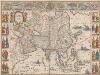
Asia noviter delineata [Karte], in: Theatrum orbis terrarum, sive, Atlas novus, Bd. 2, S. 245.
1 Karte aus Atlas Blaeu, Joan Blaeu, Willem Janszoon

Asien
Geographischer Atlas über alle Theile der Erde Ziegler, Jakob Melchior Verlag von Dietrich Reimer
Orbis veteribus notus
1 : 92500000 Afrika Meyer, Joseph Bibliographisches Institut
Asien
1 : 33633000 gezeichnet von H. Kiepert gestochen von W. Weiler Weimar : Geographisches Institut
(Western Hemisphere)
1 : 15000000 Brue, Adrien Hubert, 1786-1832
Amerique.
1 : 20000000 Champion, J. N.
Asien
1 : 20550000 entworfen und gezeichnet von C. F. Weiland gest. v. C. J. Mädel sen. Weimar : Verlag des Geograph. Instituts
Tabv Gran Rvssie / diefert sitvs orbis hydrographorvm ab eo qvem Ptolomevs posvit
1 : 39000000 1 Karte : Holzschnitt ; 28 x 45 cm Ptolemaeus, Claudius [Lorenz Fries]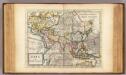
Asia.
1 : 70000000 Moll, Herman, d. 1732
Mountain Chains in Asia & Europe
The physical atlas Johnston, Alexander Keith William Blackwood & Sons
Asien zur Übersicht der natürlichen Bodenbeschaffenheit
Schul-Atlas über alle Theile der Erde nach dem neuesten Zustande, und über das Weltgebäude Stieler, Adolf Justus Perthes
Carte de Amerique
Amerika Fried, Franz Artaria & comp[ani]e
America.
1 : 55000000 Reichard, C. G.
Die den Alten bekannte Welt
Historisch-genealogisch-geographischer Atlas von Le Sage Las Cases, Emmanuel Auguste Dieudonné Marius Joseph de Johann Velten, Kunsthändler


