Maps of United States Minor Outlying Islands

Tabv Gran Rvssie / diefert sitvs orbis hydrographorvm ab eo qvem Ptolomevs posvit
1 : 39000000 1 Karte : Holzschnitt ; 28 x 45 cm Ptolemaeus, Claudius [Lorenz Fries]

Westliche Halbkugel.
1 : 100000000 Flemming, Carl
Eastern Hemisphere.
1 : 57000000 Sharpe, J.
Generale Ptholemei [Karte], in: Claudii Ptolemei viri Alexandrini mathematice discipline philosophi doctissimi geographie opus [...], S. 148.
1 Karte aus Atlas Waldseemüller, Martin [und Ptolemaeus, Claudius] Übelin, Georg
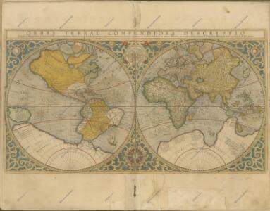
Orbis veteribus notus
1 : 92500000 Afrika Meyer, Joseph Bibliographisches Institut
Resource-Relief Maps of: Europe and Australia.
Hammond, C.S.
America
1 : 40000000 Amerika Schmidt, Johann Marius Friedrich T. Mollo
W. Hemisphere.
1 : 51000000 Hall, S. (Sidney)
W. Hemisphere.
1 : 120000000 Darton, William
OEstliche Halbkugel
Afrika
Mountain Chains in Asia & Europe
The physical atlas Johnston, Alexander Keith William Blackwood & Sons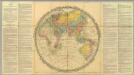
Walker's Geographical Pastime.
1 : 48000000 Walker, John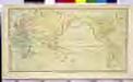
CHART of the WORLD

Asien
Neuer Handatlas über alle Theile der Erde Kiepert, Heinrich Verlag von Dietrich Reimer
Wýchodnj polokaule
Afrika Merklas, Václav
Wýchodnj polokaule
Afrika Merklas, Václav
Wýchodnj polokaule
Afrika Merklas, Václav
[Asien, Oro-hydrographische Uebersicht]
E. von Sydow's Schul-Atlas in sechs und dreissig Karten Sydow, Emil von bei Justus Perthes
Östliche Halbkugel der Erde
Afrika Berthe Gleditsch
Asien
1 : 33633000 gezeichnet von H. Kiepert gestochen von W. Weiler Weimar : Geographisches Institut
Oestliche Hemisphaere
1 : 100000000 Afrika Grimm, Johann Ludwig Schropp, Simon bei Simon Schropp
Westliche Halbkugel
Amerika
Westliche Halbkugel
Amerika
E. Hemisphere.
1 : 42000000 Thomson, John
Verbreitung der vorzuglicheren Saugethiere der Alten Welt.
1 : 50000000 Berghaus, Heinrich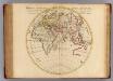
Orbis veteribus noti tabula nova.
1 : 43000000 L'Isle, Guillaume de, 1675-1726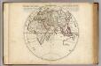
Orbis veteribus noti tabula nova.
1 : 43000000 L'Isle, Guillaume de, 1675-1726