Maps of Carpathian Mountains
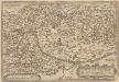
Ungariae Loca Praecipua Recens [Karte], in: Theatrum orbis terrarum, S. 363.
1 Karte aus Atlas Ortelius, Abraham Vrients, Jan Baptista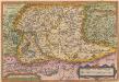
Ungariae Loca Praecipua Recens [Karte], in: Theatrum orbis terrarum, S. 268.
1 Karte aus Atlas Ortelius, Abraham
Charte von Galizien und den Ungarischen Ländern
Ungarn, Galizien
Karpaten-Land
Donau-Karpaten-Gebiet, Ungarn
Regnorum Hungariae Dalmatiae, Croatiae, Sclavoniae Bosniae et Serviae cum principatu Transylvaniae, maximaque parte Valachiae nova et exacta tabula
1 : 784000 Bosna Homann, Johann Baptist Müller, Johann Christoph á Io. Bapt. Homanno
Ungarn's Diöcesen im Anfang des XIII. Jahrh.
1 : 7400000 Ungarn Diözese, Kirchengeschichte
Ungarn bis zur Unterwerfung Croatiens um 1100
1 : 7400000 Ungarn, Kroatien
Ungarn im XII. Jahrhhundert
1 : 7400000 Ungarn
Ungarn's Diöcesen von Stephan dem Heiligen bis auf Ladislaus d. Hl.
1 : 7400000 Ungarn Diözese, Kirchenprovinz
Das Königreich Ungarn nebst den angraentzenden Kaeyserlichen Laendern / verfertiget von Joh. George
1 : 5300000 1 Karte : Kupferdruck ; 16 x 21 cm, Bildgr. 17 x 25 cm Schreiber, Johann Georg [J. G. Schreiber]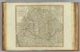
Hungary, Transilvania, Sclavonia, Croatia.
1 : 1440000 Robert Laurie & James Whittle
OCTAVA EUROPE TABULA / [Kartograph: Nicolaus Germanus ; Stecher: Johannes von Armsheim]
1 : 5100000 1 Karte : Holzschnitt ; 40 x 57 cm Ptolemaeus, Claudius [Johann Reger?]
Magyarország hegy- és vizrajzi térképe
1 : 2200000 Evropa jihovýchodní Homolka, Josef Eggenberger-féle könyvkereskedés
Hungary, Transylvania.
1 : 3801600 Lucas, Fielding Jr.
Regnorum Hungariae, Dalmatiae, Croatiae, Sclavoniae, Bosniae et Serviae cum principatu Transylvaniae, maximaque parte Valachiae nova et exacta tabula
1 : 805000 Chorvatsko Homann, Johann Baptist Müller, Johann Christoph J. B. Homann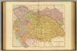
Austria-Hungary.
1 : 1774080 Stanford, Edward
Ungarn und seine Nebenlande nach ihrer kirchlichen Eintheilung bis in das XVte. Jahrhundert.
1 : 3800000 Spruner von Merz, Karl
Carte particuliere de la Hongrie de la Transilvanie de la Croatie et de la Sclavonie
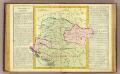
Hongrie.
1 : 2550000 Clouet, J. B. L. (Jean-Baptiste Louis), b. 1730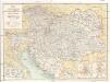
Österreich-Ungarn's Eisenbahnen
1 : 1250000 Evropa jihovýchodní Manussi-Montesole, Ferdinand Albin Edlen von Karl Prochaska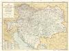
Österreich-Ungarn's Eisenbahnen
1 : 1250000 Rakousko-Uhersko Manussi-Montesole, Ferdinand Albin Edlen von Karl Prochaska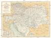
Österreich-Ungarn's Eisenbahnen
1 : 1250000 Rakousko-Uhersko Manussi-Montesole, Ferdinand Albin Edlen von Karl Prochaska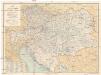
Österreich-Ungarn's Eisenbahnen
1 : 1250000 Evropa jihovýchodní Manussi-Montesole, Ferdinand Albin Edlen von Karl Prochaska
Empire Of Austria.
1 : 4435200 Burr, David H., 1803-1875
Ungarn mit seinen Nebenländern und Galizien
1 : 1600000 Dalmácie jižní (Chorvatsko) Kiepert, Heinrich Eulenstein, F. Geographisches Institut
Ungarn mit seinen Nebenländern und Galizien
1 : 1600000 Dalmácie jižní (Chorvatsko) Kiepert, Heinrich Blaschnek Verlag des Geographischen Institut
Ungarn mit seinen Nebenländern und Galizien
1 : 1600000 Dalmácie jižní (Chorvatsko) Kiepert, Heinrich Blaschnek Verlag des Geographisches Institut
Sbírka map a diagramů použitých na mírových konferencích v Paříži v letech 1919 - 1920

A new map of Hungary, withits divisions into Gespanchafts or Counties,...

![Ungariae Loca Praecipua Recens [Karte], in: Theatrum orbis terrarum, S. 363.](https://images-2.georeferencer.com/images/iiif/371065183345/full/,300/0/native.jpg)

