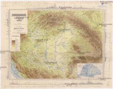
Maps of Carpathian Mountains

Magyarország hegy- és vizrajzi térképe
1 : 2200000 Evropa jihovýchodní Homolka, Josef Eggenberger-féle könyvkereskedés
Ungarn im XII. Jahrhhundert
1 : 7400000 Ungarn
Ungarn's Diöcesen im Anfang des XIII. Jahrh.
1 : 7400000 Ungarn Diözese, Kirchengeschichte
Ungarn's Diöcesen von Stephan dem Heiligen bis auf Ladislaus d. Hl.
1 : 7400000 Ungarn Diözese, Kirchenprovinz
Regnorum Hungariae Dalmatiae, Croatiae, Sclavoniae Bosniae et Serviae cum principatu Transylvaniae, maximaque parte Valachiae nova et exacta tabula
1 : 784000 Bosna Homann, Johann Baptist Müller, Johann Christoph á Io. Bapt. Homanno
Ungarn bis zur Unterwerfung Croatiens um 1100
1 : 7400000 Ungarn, Kroatien
Hungary, Transylvania.
1 : 3801600 Lucas, Fielding Jr.
Ungariae Loca Praecipua Recens [Karte], in: Theatrum orbis terrarum, S. 268.
1 Karte aus Atlas Ortelius, Abraham
Ungarn nach dem Frieden von Passarowitz 1718
1 : 7400000 Ungarn Požarevac / Friede
Szent István koronájához tartozó Orszácoknak térképe
1 : 2100000 Evropa jihovýchodní Thót, Antal Geyertol Földirati intézet
A new map of Hungary, withits divisions into Gespanchafts or Counties,...
Mappa Potamologica In Qua Fluvii Ac Fluvioli Nominatiores Fere Omnes Qui in Monarchia Hungariae ad Danubium Sive Immediate Sive Mediate Confluunt; Lacus Item Ac Paludes Idea Generali Repraesentantur
1 : 2400000 Mollova mapová sbírka Marsili, Luigi Ferdinando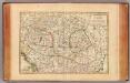
Hongrie, Transilvanie, Esclavonie, Croatie.
1 : 2650000 Janvier, Jean
Das Königreich Ungarn nebst den angraentzenden Kaeyserlichen Laendern / verfertiget von Joh. George
1 : 5300000 1 Karte : Kupferdruck ; 16 x 21 cm, Bildgr. 17 x 25 cm Schreiber, Johann Georg [J. G. Schreiber]
Regnum Hungariae cum contiguis regionibus
1 : 5800000 1 Karte : Kupferdruck ; 14 x 17 cm Weigel, Johann Christoph [Johann Christoph Weigel]
Ungarn mit seinen Nebenländern und Galizien
1 : 1600000 Dalmácie jižní (Chorvatsko) Kiepert, Heinrich Eulenstein, F. Geographisches Institut
Ungarn mit seinen Nebenländern und Galizien
1 : 1600000 Dalmácie jižní (Chorvatsko) Kiepert, Heinrich Blaschnek Verlag des Geographischen Institut
Ungarn mit seinen Nebenländern und Galizien
1 : 1600000 Dalmácie jižní (Chorvatsko) Kiepert, Heinrich Blaschnek Verlag des Geographisches Institut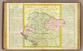
Hongrie.
1 : 2550000 Clouet, J. B. L. (Jean-Baptiste Louis), b. 1730
Hungary and Transylvania.
1 : 3800000 Lucas, Fielding Jr.
(La Hongrie)
1 : 10000000 Bruyset, Jean-Marie; Schneider, J. H.
Magyar- Orság

Tabula generalis regni Hungariae, Croatiae et Slavoniae nec non magni principatus Tranylvaniae
1 : 1400000 Chorvatsko Lipský, Ján Festetis, Georgio
Tabula generalis regni Hungariae, Croatiae et Slavoniae, nec non magni principatus Transylvaniae
1 : 1400000 Chorvatsko Lipský, Ján Festetis de Tolna, Georgio
OCTAVA EUROPE TABULA / [Kartograph: Nicolaus Germanus ; Stecher: Johannes von Armsheim]
1 : 5100000 1 Karte : Holzschnitt ; 40 x 57 cm Ptolemaeus, Claudius [Johann Reger?]
Ungariae Loca Praecipua Recens [Karte], in: Theatrum orbis terrarum, S. 363.
1 Karte aus Atlas Ortelius, Abraham Vrients, Jan Baptista
Hungary, Transilvania, Sclavonia, Croatia.
1 : 1440000 Robert Laurie & James Whittle
General Charte vom Ungarn
1 : 890000 Bukovina (Rumunsko a Ukrajina) Güssefeld, Franz L. Rausch, J. Homannischen Erben
Feuille 32 (D V), uit: Carte géologique internationale de l'Europe : la carte, votée au congrès géologique international de Bologne en 1881, est exécutée conformément aux décisions d'une commission internationale, avec le concours des gouvernements, sous le dir. de M.M. Beyrich et Hauchecorne
Annotatie: Blad 48 gamme des couleurs; blad 49: bladwijzer en titelblad Heinrich Ernst Beyrich 1815-1896; Wi. Hauchecorne Berlin : Reimer / (Berlin: Institut lithographique)