Maps of Carpathian Mountains

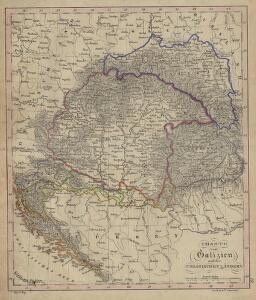
Charte von Galizien und den Ungarischen Ländern
Ungarn, Galizien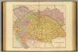
Austria-Hungary.
1 : 1774080 Stanford, Edward
OCTAVA EUROPE TABULA / [Kartograph: Nicolaus Germanus ; Stecher: Johannes von Armsheim]
1 : 5100000 1 Karte : Holzschnitt ; 40 x 57 cm Ptolemaeus, Claudius [Johann Reger?]
Osterreich – Ungarn


Österreich-Ungarn, Religionen
Österreich-Ungarn Denomination
Osterreichischer Kaiserstaat.
1 : 3900000 Flemming, Carl
Instruktion für die Evidenzhaltung der Kartenwerke
G. Freytags Verkehrs-Karte von Österreich-Ungarn
1 : 1400000 Evropa jihovýchodní Freytag, Gustav G. Freytag und Berndt
Empire Of Austria.
1 : 4435200 Burr, David H., 1803-1875
Mocnářství Rakousko - Uherské

Karte des mittleren und höheren Unterrichtswesens sowie der Elementarbildung der Bevölkerung
Rakousko-Uhersko Le-Monnier, Franz von Eduard Hölzel
Kaiserthum Oesterreich
1 : 1800000 Rakousko-Uhersko Bomsdorff, Th. von Karl Prochaska
Schulkarte von Österreich-Ungarn

Österreichisch-Ungarische Monarchie
1 : 3000000 Rakousko-Uhersko Roese, W. Artaria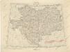
Übersichtblatt der Spezialkarte 1:75 000

Bez titulu: Östereich

Hvngaria Magna In Regna et Prouincias diuisa
1 : 7400000 Mollova mapová sbírka
Le Royaume de Hongrie
1 : 2400000 Mollova mapová sbírka Valk, Gerhard Valck, Gerard
Šolcova nejnovější politická a železniční cestovní mapa Rakousko-Uherska
1 : 1600000 Rakousko-Uhersko Srp, Jan Emil Šolc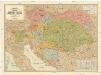
Šolcova nejnovější politická a železniční cestovní mapa Rakousko-Uherska
1 : 1600000 Rakousko-Uhersko Srp, Jan Emil Šolc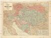
Šolcova nejnovější politická a železniční cestovní mapa Rakousko-Uherska
1 : 1600000 Rakousko-Uhersko Srp, Jan Emil Šolc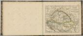

Mocnářství Rakousko - Uherské

Austrian Empire.
1 : 3380000 Sharpe, J.
Ethnographical map of Austria-Hungary. 1918
1 : 4000000 First World War ethnographical map of Austria-Hungary. 1918. War Office
Bez titulu: Östereich

Das Kaiserthum Oesterreich
1 : 2800000 Rakousko (1804-1867) im k.k. Schulbücher-Verlage
Das Kaiserthum Oesterreich
1 : 2800000 Rakousko (1804-1867) im k.k. Schulbücher-Verlage