Maps of Carpathian Mountains

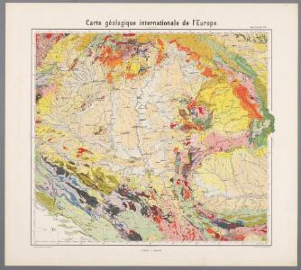
Feuille 32 (D V), uit: Carte géologique internationale de l'Europe : la carte, votée au congrès géologique international de Bologne en 1881, est exécutée conformément aux décisions d'une commission internationale, avec le concours des gouvernements, sous le dir. de M.M. Beyrich et Hauchecorne
Annotatie: Blad 48 gamme des couleurs; blad 49: bladwijzer en titelblad Heinrich Ernst Beyrich 1815-1896; Wi. Hauchecorne Berlin : Reimer / (Berlin: Institut lithographique)
Regnum Hungariae cum contiguis regionibus
1 : 5800000 1 Karte : Kupferdruck ; 14 x 17 cm Weigel, Johann Christoph [Johann Christoph Weigel]
Das Königreich Ungarn nebst den angraentzenden Kaeyserlichen Laendern / verfertiget von Joh. George
1 : 5300000 1 Karte : Kupferdruck ; 16 x 21 cm, Bildgr. 17 x 25 cm Schreiber, Johann Georg [J. G. Schreiber]
(La Hongrie)
1 : 10000000 Bruyset, Jean-Marie; Schneider, J. H.
Regnorum Hungariae, Dalmatiae, Croatiae, Sclavoniae, Bosniae, Serviae et principatus Transylvaniae novissima exhibitio facta
1 : 2000000 Chorvatsko Homann, Johann Baptist J. B. Homann
Ungarn's Diöcesen im Anfang des XIII. Jahrh.
1 : 7400000 Ungarn Diözese, Kirchengeschichte
Ungarn im XII. Jahrhhundert
1 : 7400000 Ungarn
Charte von Galizien und den Ungarischen Ländern
Ungarn, Galizien
Hungaria Seraphico-Observans
1 : 2100000 Mollova mapová sbírka Seutter, Matthäus Lotter, Elias Tobias
Ungarn bis zur Unterwerfung Croatiens um 1100
1 : 7400000 Ungarn, Kroatien
Ungarn's Diöcesen von Stephan dem Heiligen bis auf Ladislaus d. Hl.
1 : 7400000 Ungarn Diözese, Kirchenprovinz
Hungary and Transylvania.
1 : 3800000 Lucas, Fielding Jr.
Exactissima Tabula, qua tam Danubii Fluvii Pars Media
1 : 2100000 Mollova mapová sbírka Visscher, Nicolaes Jansz. Visscher, Nicolaus
Exactissima Tabula, qua tam Danubii Fluvii Pars Media
1 : 2100000 Mollova mapová sbírka Visscher, Nicolaes Jansz. Visscher, Nicolaus
Il Regno d'Vngaria Transilvania, Schiavonia, Bosnia, Croatia, Dalmatia.
1 : 2100000 Mollova mapová sbírka De Rossi, Giovanni Giacomo De Rossi, Giovanni Giacomo
Novißima et accuratißima Hungariae cum circumjacentibus regnis et principatibus in mappa geographica designatio
1 : 2000000 Evropa jihovýchodní Seutter, Matthäus Probst, Johann Michael Ioh. Mich. Probst
Novißima et accuratißima Hungariae
1 : 2000000 Balkánský poloostrov Seutter, Matthäus M. Seutter
Nova et accurata Hungariae
1 : 2000000 Balkánský poloostrov Seutter, Matthäus M. Seutter
Novißima et accuratißima Hungariae cum circumjacentibus regnis et principatibus in mappa geographica designatio
1 : 2000000 Evropa jihovýchodní Seutter, Matthäus impensis Matthaei Seutteri
Nova et accurata Hungariae cum adiacentib. regn. et principatibus tabula
1 : 2000000 Evropa jihovýchodní Seutter, Matthäus a Matth. Seuttero
Magyarország hegy- és vizrajzi térképe
1 : 2200000 Evropa jihovýchodní Homolka, Josef Eggenberger-féle könyvkereskedés
Regnorum Hungariae Dalmatiae, Croatiae, Sclavoniae Bosniae et Serviae cum principatu Transylvaniae, maximaque parte Valachiae nova et exacta tabula
1 : 784000 Bosna Homann, Johann Baptist Müller, Johann Christoph á Io. Bapt. Homanno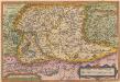
Ungariae Loca Praecipua Recens [Karte], in: Theatrum orbis terrarum, S. 268.
1 Karte aus Atlas Ortelius, Abraham
Totius imperii Russici tabula generalis / ex optimis quibusvis Academiae Petropolit. mappis, quarum
1 : 7300000 1 Karte auf 3 Blatt : Kupferdruck ; 56 x 129 cm ; Einzelbl. 56 x 43 cm Büsching, Anton Friedrich [Verlag nicht ermittelbar]
Exactissima tabula qua tam Danubii fluvii pars media, ab urbe lentiae ad Bydenam urbem et minores in eum influentes fluvii, quam regiones adjacentes ut Hungaria, Slavonia, Croatia, Bosnia, Dalmatia, Servia, nec non Germaniae, Poloniae, et Graeciae confinia ostenduntur
1 : 1750000 Bosna Visscher, Nicolaus N. Visscher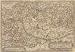
Ungariae Loca Praecipua Recens [Karte], in: Theatrum orbis terrarum, S. 363.
1 Karte aus Atlas Ortelius, Abraham Vrients, Jan Baptista
General Charte vom Ungarn
1 : 890000 Bukovina (Rumunsko a Ukrajina) Güssefeld, Franz L. Rausch, J. Homannischen Erben
Regni Hungariae
1 : 1400000 Mollova mapová sbírka Homann, Johann Baptist Homann, Johann Baptista - dědici
Ungarn nach dem Frieden von Passarowitz 1718
1 : 7400000 Ungarn Požarevac / Friede