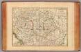
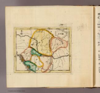
Maps of Carpathian Mountains

(La Hongrie)
1 : 10000000 Bruyset, Jean-Marie; Schneider, J. H.
Totius imperii Russici tabula generalis / ex optimis quibusvis Academiae Petropolit. mappis, quarum
1 : 7300000 1 Karte auf 3 Blatt : Kupferdruck ; 56 x 129 cm ; Einzelbl. 56 x 43 cm Büsching, Anton Friedrich [Verlag nicht ermittelbar]
Galizien, Ungarn, Slavonien, Kroatien, Siebenburgen, Dalmatien, Moldau, Wallachey.
1 : 10000000 Brudin, J. L.; Stieler, Adolf
OCTAVA EUROPE TABULA / [Kartograph: Nicolaus Germanus ; Stecher: Johannes von Armsheim]
1 : 5100000 1 Karte : Holzschnitt ; 40 x 57 cm Ptolemaeus, Claudius [Johann Reger?]
Ungarn und seine Nebenlande nach ihrer kirchlichen Eintheilung bis in das XVte. Jahrhundert.
1 : 3800000 Spruner von Merz, Karl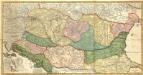
Novissima et Accuratissima totius Regni Hungariae, Dalmatiae, Croatiae, Sclavoniae, Bosniae, Serviae, Transylvaniae, cum Adiacentibus Regnis et Provinciis Tabula
1 : 2100000 Mollova mapová sbírka Sandrart, Jakob von Sandrart, Jacob von
Regnorum Hungariae Dalmatiae, Croatiae, Sclavoniae Bosniae et Serviae cum principatu Transylvaniae, maximaque parte Valachiae nova et exacta tabula
1 : 784000 Bosna Homann, Johann Baptist Müller, Johann Christoph á Io. Bapt. Homanno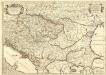
Le Royaume de Hongrie et les Estats qui en ont Esté sujets et qui font presentement la Partie Septentrionale de la Turquie en Europe.
1 : 2500000 Mollova mapová sbírka Sanson, Guillaume Cordier, Louis Jaillot, Alexis Hubert
Feuille 32 (D V), uit: Carte géologique internationale de l'Europe : la carte, votée au congrès géologique international de Bologne en 1881, est exécutée conformément aux décisions d'une commission internationale, avec le concours des gouvernements, sous le dir. de M.M. Beyrich et Hauchecorne
Annotatie: Blad 48 gamme des couleurs; blad 49: bladwijzer en titelblad Heinrich Ernst Beyrich 1815-1896; Wi. Hauchecorne Berlin : Reimer / (Berlin: Institut lithographique)
Regnum Hungariae cum contiguis regionibus
1 : 5800000 1 Karte : Kupferdruck ; 14 x 17 cm Weigel, Johann Christoph [Johann Christoph Weigel]
[Galizien, Ungarn Slavonien und Croatien, Siebenbürgen und Dalmatien, Moldau, Wallachey]
Hand-Atlas über alle Theile der Erde nach dem neuesten Zustande und über das Weltgebäude Stieler, Adolf bei Justus Perthes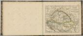

Ungarn und seine Nebenlande vom Regierungs-Antritte des Hauses Anjou bis zur Schlacht von Mohacs 1526.
1 : 3800000 Spruner von Merz, Karl
Galizien, Ungarn mit Slavonien und Croatien, Siebenbürgen und Dalmatien, Moldau, Wallachey
1 : 3700000 Chorvatsko Justus Perthes
Russland. I. Das europaeische Russland, II. Das Königreich Polen, III. Die Republik Krakau
1 : 2500000 1 Karte : Lithographie ; 27 x 20 cm Schlieben, W.E.A. von [Georg Joachim Göschen]
Die Laender an der untern Donau Vten.-Xte. Jahrhundert.
1 : 3800000 Spruner von Merz, Karl
Galizien, Ungarn mit Sclavonien und Croatien, Siebenbürgen und Dalmatien; Moldau, Walachey]
Stieler's Hand-Atlas Stieler, Adolf bei Justus Perthes
General Charte vom Ungarn
1 : 890000 Bukovina (Rumunsko a Ukrajina) Güssefeld, Franz L. Rausch, J. Homannischen Erben
Russia in Europe / drawn & engraved by J. Dower ...
1 : 15000000 1 Karte : Lithogr. (mehrfarb.) ; 25 x 20 cm Dower, John Orr & Smith
Ungarn und seine Nebenlande bis zum Aussterben Arpadischen Stammers 1301.
1 : 3800000 Spruner von Merz, Karl
Nova et Accurata Regni Hungariae Tabula, ad Usum Serenissimi Burgundiae Ducis
1 : 2900000 Mollova mapová sbírka Jaillot, Alexis-Hubert Ottens, Josua
Nova et Accurata Tabula Regnorum Sup. et Inf. Hungariae
1 : 2500000 Mollova mapová sbírka Bodenehr, Gabriel Bodenehr, Gabriel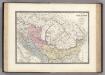
Dacie, Pannonie, Illyrie, Moesie Ancienne.
1 : 2886000 Levasseur, E.
Das Königreich Ungarn nebst den angraentzenden Kaeyserlichen Laendern / verfertiget von Joh. George
1 : 5300000 1 Karte : Kupferdruck ; 16 x 21 cm, Bildgr. 17 x 25 cm Schreiber, Johann Georg [J. G. Schreiber]
Ungarn's Diöcesen im Anfang des XIII. Jahrh.
1 : 7400000 Ungarn Diözese, Kirchengeschichte

Pohraničí Rakousko-Uherska, Rumunska, Srbska a Bulharska
1 : 1250000 Bulharsko Machát, František V. Neubert
Le Royaume de Hongrie
1 : 2400000 Mollova mapová sbírka Valk, Gerhard Valck, Gerard
Ungarn im XII. Jahrhhundert
1 : 7400000 Ungarn