Maps of Carpathian Mountains
Le Royaume de Hongrie et les Estats qui en ont Esté sujets et qui font presentement la Partie Septentrionale de la Turquie en Europe.
1 : 2500000 Mollova mapová sbírka Sanson, Guillaume Cordier, Louis Jaillot, Alexis Hubert
Le Royaume de Hongrie
1 : 2400000 Mollova mapová sbírka Valk, Gerhard Valck, Gerard
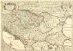
Hvngaria Magna In Regna et Prouincias diuisa
1 : 7400000 Mollova mapová sbírka
Nova et Accurata Regni Hungariae Tabula, ad Usum Serenissimi Burgundiae Ducis
1 : 2900000 Mollova mapová sbírka Jaillot, Alexis-Hubert Ottens, Josua
Nova et Accurata Tabula Regnorum Sup. et Inf. Hungariae
1 : 2500000 Mollova mapová sbírka Bodenehr, Gabriel Bodenehr, Gabriel
Die Laender an der untern Donau Vten.-Xte. Jahrhundert.
1 : 3800000 Spruner von Merz, Karl
Le royaume de Hongrie
1 : 260000 Uhersko Delisle, Guillaume Covens et Mortier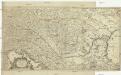
Totius Regni Hungariae et adjacentium regionum tabula
1 : 2200000 Dunaj-oblast Visscher, Nicolaes Jansz.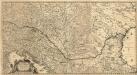
Totius Regni Hungariae
1 : 2200000 Mollova mapová sbírka Visscher, Nicolaes Jansz.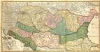
Novissima et Accuratissima totius Regni Hungariae, Dalmatiae, Croatiae, Sclavoniae, Bosniae, Serviae, Transylvaniae, cum Adiacentibus Regnis et Provinciis Tabula
1 : 2100000 Mollova mapová sbírka Sandrart, Jakob von Sandrart, Jacob von
Galizien, Ungarn mit Sclavonien und Croatien, Siebenbürgen und Dalmatien; Moldau, Walachey]
Stieler's Hand-Atlas Stieler, Adolf bei Justus Perthes
[Galizien, Ungarn Slavonien und Croatien, Siebenbürgen und Dalmatien, Moldau, Wallachey]
Hand-Atlas über alle Theile der Erde nach dem neuesten Zustande und über das Weltgebäude Stieler, Adolf bei Justus Perthes
Ungarn und seine Nebenlande bis zum Aussterben Arpadischen Stammers 1301.
1 : 3800000 Spruner von Merz, Karl
Le Royaume de Hongrie
1 : 1300000 Mollova mapová sbírka Sanson, Guillaume Covens, Johannes I
Der Donauraum
1 : 1500000 Dunaj-oblast Justus Perthes
Artaria's Eisenbahn- u. Post- Communications-Karte v. Oesterreich-Ungarn
1 : 1700000 Rakousko-Uhersko Skrzeszewski, F. von Artaria & Comp.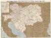
Artaria's Eisenbahn- u. Post- Communications-Karte v. Oesterreich-Ungarn
1 : 1700000 Rakousko-Uhersko Skrzeszewski, F. R. Artaria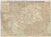
Artaria's Eisenbahn- u. Post-Communications-Karte v. Oesterreich-Ungarn
1 : 1700000 Budapešť-oblast (Maďarsko) Artaria
Artaria's Eisenbahn- u. Post-Communications-Karte v. Oesterreich-Ungarn
1 : 1700000 Budapešť (Maďarsko) Artaria
Nieuwe kaart van Hongarien en het noordelyke deel van Turkyen
1 : 5000000 [S.l.] : [s.n.]
Le Royaume de Hongrie et des pays qui en dependoient autrefois ; Nova et accurata Regni Hungariae tabula, ad usum serenissimi Burgundiae ducis
Ungarn, Osmanisches Reich L'Isle, Guillaume de
Carte Geographique du Theatre de la Guerre en General representant le Royaume de Hongarie
1 : 1300000 Mollova mapová sbírka Lotter, Tobias Conrad Lotter, Tobias Conrad
Karpatenländer, Flusz- & Gebirgskarte
1 : 6000000 Donau-Karpaten-Gebiet

90-91. Danube Countries. The World Atlas.
1 : 2500000 USSR (Union of Soviet Socialist Republics).
Le Royaume de Hongrie...

Karpatenländer, politische Übersicht
1 : 6000000 Donau-Karpaten-Gebiet
Eigentlliche Forstellung des soberühmten könig. Reichs Ungarn neben Sibenbürgen, Moldau, Wallachen, Bosnien und anderr Ländern mehr bis an Constantinopel
1 : 2000000 Bosna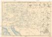
Eisenbahn-Routen-Karte für Österreich-Ungarn
Bratislava (Slovensko) Ritter, J. R. v. Waldheim


