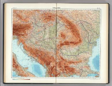
Maps of Balkan Pen.

90-91. Danube Countries. The World Atlas.
1 : 2500000 USSR (Union of Soviet Socialist Republics).
Augustissimi et invictissimi romanorum imperatoris haereditarium regnum Hungaria
1 : 2000000 Besarábie (Moldavsko a Ukrajina) Sedlmeyer, Ioannis Pauli Heckenauer, Jakob Wilhelm J. P. Sedlmeyer
Theatrum Belli Russo-Turcici
1 : 2100000 Mollova mapová sbírka Probst, Johann Michael
Novissima et accuratissima toti. regni Hungariae, Dalmatiae, Croatiae, Sclavoniae, Bosniae, Serviae, Transylvaniae, cum adiacentib. regnis et provinciis tabula
1 : 1600000 Bosna Sandrart, Johann Jakob von J. J. von Sandrart
Der Donauraum
1 : 1500000 Dunaj-oblast Justus Perthes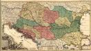
Novissima Tabula Regni Hungariae et Regionum quondam ei unitarum
1 : 2000000 Mollova mapová sbírka Ottens, Josua Keyser, Jacob Ottens, Josua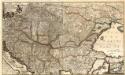
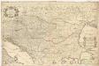
Accurate Landkarte die Königreiche Ober- und Nieder-Hungarn, Slavonien, Croatien, Dalmatien, Bosnien, Servien, Bulgarien, und Romanien, das Groß Fürstenthum Siebenbürgen, die Fürstenthümer Moldau, Wallachey, Bessarabien, die Oczakowisch- und Crimische Tartarey, die Pohlnische Provinz Podolien, wie auch ein Theil von Ukranien, und übrige angränzende Ländere
Mollova mapová sbírka Lidl, Johann Jakob Lidl, Johann Jacob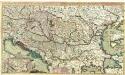
Theatre de la Guerre en Hongrie, Bosnie, Servie, et Tartarie Crimee, en il Grandes Feuilles
1 : 2000000 Mollova mapová sbírka Briffaut, Etienne Briffaut, Etienne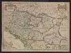
Le Royaume de Hongrie et les estats qui en esté sujets et qui sont presentement la partie septentrionale de la Turquie en Europe. Tiré des memoires les plus nouveaux
1 : 2100000 Ungarn, Südosteuropa Sanson, Guillaume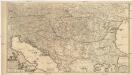
Regni Hungariae, et regionum, quae ei quondam fuere unitae, ut Transilvaniae, Valachiae, Moldaviae, Serviae, Romaniae, Bulgariae, Bessarabiae, Croatiae, Bosniae, Dalmatiae, Sclavoniae, Morlachiae, Ragusanae reipublicae maximaeq[ue] partis Danubii fluminis novissima delineatio
1 : 2100000 Besarábie (Moldavsko a Ukrajina) Wit, Frederick de ex officina Frederici de Wit
Regnum Hungariae, in quo continentur Regiones
1 : 5900000 Mollova mapová sbírka Bruggen, Johann van der Brugge, Johannes van der
Regnum Hungariae, in quo continentur Regiones :
1 : 5900000 Mollova mapová sbírka Bruggen, Johann van der Brugge, Johannes van der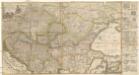
Accurate Landkarte die Königreiche Ober- und Nieder- Hungarn, Slavonien, Croatien, Dalmatien, Bosnien, Servien, Bulgarien und Romanien, das Gross Fürstenthum Siebenbürgen, die Fürstenthümer Moldau, Wallachen, Bessarabien, die Oczakowisch- und Crimische Tartaren, die Pohlnische Provinz Podolien, wie auch ein Theil von Ukranien, und übrige angränzende Ländere vorstellend
1 : 1430000 Besarábie (Moldavsko a Ukrajina) Lidl, Johann Jakob Joh. Jacob Lidl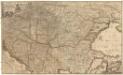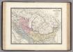
Dacie, Pannonie, Illyrie, Moesie Ancienne.
1 : 2886000 Levasseur, E.
Daciarum, Moesiarumque, Vetus Descriptio. [Karte], in: Theatrum orbis terrarum, S. 505.
1 Karte aus Atlas Ortelius, Abraham Vrients, Jan Baptista
Hungariae ampliori significatu...

Hungariae
1 : 2600000 Balkánský poloostrov Hase, Johann Matthias Homannianos Heredes
HUNGARIAE ampliori significatu et veteris vel Methodicae, complexae REGNA
1 : 2600000 Bosna Hase, Johann Matthias curantibus Homannianis Heredibus
Hungariae
1 : 2600000 Balkánský poloostrov Hase, Johann Matthias Homannianis Heredibus
Österreich-Ungarn, Staatenkarte
1 : 4500000 Österreich-Ungarn
Nova et Accurata Tabula Sedis Belli in Regno
1 : 1500000 Mollova mapová sbírka Schenk, Pieter Schenk, Peter II
Karpaten-Länder
Donau-Karpaten-Gebiet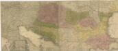
Carte geographique representant le théatre de la guerre entre les Russes, les Turcs, et les Polonis Confédérés ...
Le royaume de Hongrie et les estats qui en ont esté sujets, et qui font presentement la partie septentrionale de la Turquie en Europe
1 : 2250000 Bosna Sanson, Guillaume Jaillot, Alexis-Hubert chez H. Iaillot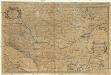
Le royaume de Hongrie
1 : 2300000 Bosna Sanson, Nicolas H. Iaillot
Südosteuropa mit den von 1919 bis 1938 geltenden Staatsgrenzen
Südosteuropa Grenzen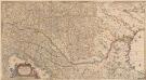
Totius Regni Hungariae, Maximaeque Partis Danubii Fluminis, una cum adjacentibus et finitimis Regionibus Novissima Delineatio [Karte], in: Novus atlas absolutissimus, Bd. 2, S. 293.
1 Karte aus Atlas Janssonius Offizin
Ost-Europa, No. 5: Sud-West-Russland & die Turkei.
1 : 3700000 Petermann, A.