Maps of Carpathian Mountains

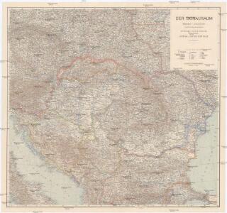
Der Donauraum
1 : 1500000 Dunaj-oblast Justus Perthes
Die Donaustaaten
Österreich-Ungarn. Völker
1 : 9000000 Österreich-Ungarn Ethnische Gruppe
Südosteuropa mit den von 1919 bis 1938 geltenden Staatsgrenzen
Südosteuropa Grenzen
Artaria's Eisenbahnkarte
1 : 1500000 Evropa jihovýchodní Peucker, Karl Artaria
Karte der wichtigsten Eisenbahnen Österreich-Ungarns und den angrenzenden Gebiete
1 : 6000000 Rakousko-Uhersko Rothaug, Johann Georg F. Tempsky
Die Donaustaaten
1 : 2500000 Dunaj-oblast Steinhauser, Anton Peucker, Karl Artaria
Totius Regni Hungariae, Maximaeque Partis Danubii Fluminis, una cum adjacentibus et finitimis Regionibus Novissima Delineatio [Karte], in: Novus atlas absolutissimus, Bd. 2, S. 293.
1 Karte aus Atlas Janssonius Offizin
Karpaten-Länder
Donau-Karpaten-Gebiet
Totius Regni Hungariae maximaeque partis Danubii fluminis, una cum adjacentibus et finitimis regionibus novissima delineatio / per Nicolaum Visscher
1 : 2000000 Annotatie: Origineel is Blad 130 in atlas factice; Annotatie geografische gegevens: Met 2 schaalstokken Nicolaes Jansz. Visscher jr. 1649-1702 [Amsterdam : per Nicolaum Visscher]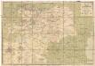
Eisenbahn-Karte der oesterreichisch-ungarischen Monarchie
1 : 1228000 Budapešť (Maďarsko : oblast) Beer, Josef A. Hartleben
Österreich-Ungarn. Rumänien, Serbien, Montenegro, Bulgarien & Ost-Rumelien
Adolf Stieler's Handatlas über alle Theile der Erde und über das Weltgebäude Stieler, Adolf Justus Perthes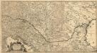
Totius Regni Hungariae
1 : 2200000 Mollova mapová sbírka Visscher, Nicolaes Jansz.
Der Österreichische Kaiserstaat
Hand-Atlas über alle Theile der Erde und über das Weltgebäude Stieler, Adolf Justus Perthes
Österreich-Ungarn, Staatenkarte
1 : 4500000 Österreich-Ungarn
Die Donauländer
1 : 5000000 Österreich-Ungarn, Balkanhalbinsel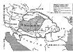
Ungarn nach dem Ersten Weltkrieg
Ungarn Weltkrieg <1914-1918>, Grenze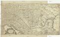
Totius Regni Hungariae et adjacentium regionum tabula
1 : 2200000 Dunaj-oblast Visscher, Nicolaes Jansz.
Galizien, Ungarn mit Slavonien und Croatien, Siebenbürgen und Dalmatien, Moldau, Wallachey
Hand-Atlas über alle Theile der Erde nach dem neuesten Zustande und über das Weltgebäude Stieler, Adolf bei Justus Perthes
Hvngaria Magna In Regna et Prouincias diuisa
1 : 7400000 Mollova mapová sbírka
Uibersichts-Karte v. Oesterreich-Ungarn
1 : 2500000 Rakousko-Uhersko Steinhauser, Anton Artaria
Le Royaume De Hongrie, et les Estats qui en ont esté sujets, et qui sont preventement La Partie Septentrionale De La Tourquie En Europe [Karte], in: Atlas nouveau, contenant toutes les parties du monde [...], Bd. 2, S. 197.
1 Karte aus Atlas Sanson, Nicolas Jaillot, Alexis Hubert und Mortier, Pieter
90-91. Danube Countries. The World Atlas.
1 : 2500000 USSR (Union of Soviet Socialist Republics).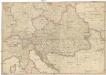
General Karte des Österreichischen Erb-Kaiserthums
1 : 2470000 Evropa jihovýchodní Mollo, Tranquillo T. Mollo
Karte der politischen Justiz- und Militär- Verwaltungsbezirke im Kaiserthume Oesterreich
Evropa jihovýchodní Schnabel, Jiří Norbert Machek, A.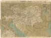
Prochaska ́s Neue Eisenbahnkarte von Österreich-Ungarn für 1898

Artaria's Eisenbahn- u. Post-Communications-Karte v. Oesterreich-Ungarn
1 : 1745000 Rakousko-Uhersko Artaria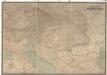
Hölzels Verkehrskarte von Österreich-Ungarn
1 : 800000 Rakousko-Uhersko Kallina, Leopold Hölzel, Eduard Ed. Hölzels geogr. Institut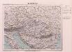
Oesterreich
Österreich-Ungarn