Maps of Carpathian Mountains
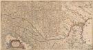
Totius Regni Hungariae, Maximaeque Partis Danubii Fluminis, una cum adjacentibus et finitimis Regionibus Novissima Delineatio [Karte], in: Novus atlas absolutissimus, Bd. 2, S. 293.
1 Karte aus Atlas Janssonius Offizin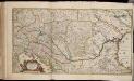
Totius Regni Hungariae maximaeque partis Danubii fluminis, una cum adjacentibus et finitimis regionibus novissima delineatio / per Nicolaum Visscher
1 : 2000000 Annotatie: Origineel is Blad 130 in atlas factice; Annotatie geografische gegevens: Met 2 schaalstokken Nicolaes Jansz. Visscher jr. 1649-1702 [Amsterdam : per Nicolaum Visscher]
Eisenbahn-Karte der oesterreichisch-ungarischen Monarchie
1 : 1228000 Budapešť (Maďarsko : oblast) Beer, Josef A. Hartleben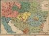
Österreich-Ungarn. Völker
1 : 9000000 Österreich-Ungarn Ethnische Gruppe
Die Donaustaaten

Artaria's Eisenbahnkarte
1 : 1500000 Evropa jihovýchodní Peucker, Karl Artaria
Galizien, Ungarn mit Slavonien und Croatien, Siebenbürgen und Dalmatien, Moldau, Wallachey
Hand-Atlas über alle Theile der Erde nach dem neuesten Zustande und über das Weltgebäude Stieler, Adolf bei Justus Perthes
Die Donaustaaten
1 : 2500000 Dunaj-oblast Steinhauser, Anton Peucker, Karl Artaria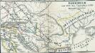
Pannonien zur Zeit des Svatopluk 895
1 : 15000000 Pannonien Swatopluk I., Mähren, Herzog
Karte der wichtigsten Eisenbahnen Österreich-Ungarns und den angrenzenden Gebiete
1 : 6000000 Rakousko-Uhersko Rothaug, Johann Georg F. Tempsky
Prochaska ́s Neue Eisenbahnkarte von Österreich-Ungarn für 1898

Karte der politischen Justiz- und Militär- Verwaltungsbezirke im Kaiserthume Oesterreich
Evropa jihovýchodní Schnabel, Jiří Norbert Machek, A.
Der Donauraum
1 : 1500000 Dunaj-oblast Justus Perthes
Österreich-Ungarn. Rumänien, Serbien, Montenegro, Bulgarien & Ost-Rumelien
Adolf Stieler's Handatlas über alle Theile der Erde und über das Weltgebäude Stieler, Adolf Justus Perthes
Südosteuropa mit den von 1919 bis 1938 geltenden Staatsgrenzen
Südosteuropa Grenzen
Der Österreichische Kaiserstaat
Hand-Atlas über alle Theile der Erde und über das Weltgebäude Stieler, Adolf Justus Perthes
Eisenbahn-Routen-Karte für Österreich-Ungarn
Bratislava (Slovensko) Ritter, J. R. v. Waldheim
Eisenbahn-Routen-Karte für Österreich-Ungarn
Rakousko-Uhersko Ritter, J. R. v. Waldheim
Carte geographique representant le théatre de la guerre entre les Russes, les Turcs, et les Polonis Confédérés ...

Karpaten-Länder
Donau-Karpaten-Gebiet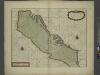
A sea chart of the Gulph of VENICE describing all the sea coasts and Islands contained therein
from The sea-atlas : containing an hydrographical description of most of the sea-coasts of the known parts of the world.
Le Cours Du Danube Depuis sa Source Iusqu'a ses Embouchures [Karte] Le Bosphore De Thrace [...] [Nebenkarte], in: Atlas nouveau, contenant toutes les parties du monde [...], Bd. 1, S. 249.
1 Karte aus Atlas Sanson, Nicolas Jaillot, Alexis Hubert und Mortier, Pieter
Österreichisch-Ungarische Monarchie
Handatlas über alle Theile der Erde und über das Weltgebäude Stieler, Adolf Justus Perthes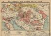
Österreich-Ungarn. Landwirtschaft und Fischerei
1 : 9000000 Österreich-Ungarn Landwirtschaft, Fischerei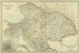
Composite: Austro-Hungarian Monarchy.
1 : 1642000 Johnston, W. & A.K.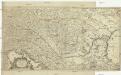
Totius Regni Hungariae et adjacentium regionum tabula
1 : 2200000 Dunaj-oblast Visscher, Nicolaes Jansz.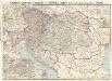
Artaria's Eisenbahn- u. Postkarte von Oesterreich-Ungarn
1 : 1500000 Budapešť (Maďarsko) Artaria
Österreich-Ungarn, Staatenkarte
1 : 4500000 Österreich-Ungarn
Ungarn nach dem Ersten Weltkrieg
Ungarn Weltkrieg <1914-1918>, Grenze
![Totius Regni Hungariae, Maximaeque Partis Danubii Fluminis, una cum adjacentibus et finitimis Regionibus Novissima Delineatio [Karte], in: Novus atlas absolutissimus, Bd. 2, S. 293.](https://images-2.georeferencer.com/images/iiif/422777371283/full/,300/0/native.jpg)

