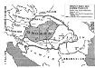
Maps of Ukraine
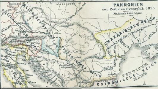
Pannonien zur Zeit des Svatopluk 895
1 : 15000000 Pannonien Swatopluk I., Mähren, Herzog
Galizien, Ungarn mit Slavonien und Croatien, Siebenbürgen und Dalmatien, Moldau, Wallachey
Hand-Atlas über alle Theile der Erde nach dem neuesten Zustande und über das Weltgebäude Stieler, Adolf bei Justus Perthes
Prochaska ́s Neue Eisenbahnkarte von Österreich-Ungarn für 1898
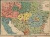
Österreich-Ungarn. Völker
1 : 9000000 Österreich-Ungarn Ethnische Gruppe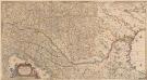
Totius Regni Hungariae, Maximaeque Partis Danubii Fluminis, una cum adjacentibus et finitimis Regionibus Novissima Delineatio [Karte], in: Novus atlas absolutissimus, Bd. 2, S. 293.
1 Karte aus Atlas Janssonius Offizin
Österreich-Ungarn. Rumänien, Serbien, Montenegro, Bulgarien & Ost-Rumelien
Adolf Stieler's Handatlas über alle Theile der Erde und über das Weltgebäude Stieler, Adolf Justus Perthes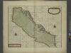
A sea chart of the Gulph of VENICE describing all the sea coasts and Islands contained therein
from The sea-atlas : containing an hydrographical description of most of the sea-coasts of the known parts of the world.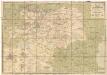
Eisenbahn-Karte der oesterreichisch-ungarischen Monarchie
1 : 1228000 Budapešť (Maďarsko : oblast) Beer, Josef A. Hartleben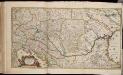
Totius Regni Hungariae maximaeque partis Danubii fluminis, una cum adjacentibus et finitimis regionibus novissima delineatio / per Nicolaum Visscher
1 : 2000000 Annotatie: Origineel is Blad 130 in atlas factice; Annotatie geografische gegevens: Met 2 schaalstokken Nicolaes Jansz. Visscher jr. 1649-1702 [Amsterdam : per Nicolaum Visscher]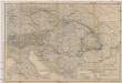
Oesterreichisch-ungarische Monarchie
1 : 2500000 Rakousko-Uhersko Geographisches Institut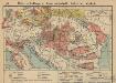
Österreich-Ungarn. Landwirtschaft und Fischerei
1 : 9000000 Österreich-Ungarn Landwirtschaft, Fischerei
Der Österreichische Kaiserstaat
Hand-Atlas über alle Theile der Erde und über das Weltgebäude Stieler, Adolf Justus Perthes
Die Donaustaaten
1 : 2500000 Dunaj-oblast Steinhauser, Anton Peucker, Karl Artaria
Die Donaustaaten

Artaria's Eisenbahnkarte
1 : 1500000 Evropa jihovýchodní Peucker, Karl Artaria
Danubius, Fluvius Europae Maximus. A Fontibus Ad Ostia, Cum omnibus Fluminis, ab utroque latere, in illum fluentibus. [Karte], in: Gerardi Mercatoris et I. Hondii Newer Atlas, oder, Grosses Weltbuch, Bd. 1, S. 233.
1 Karte aus Atlas Mercator, Gerhard und Hondius, Jodocus Jansson, Jan
Karte der wichtigsten Eisenbahnen Österreich-Ungarns und den angrenzenden Gebiete
1 : 6000000 Rakousko-Uhersko Rothaug, Johann Georg F. Tempsky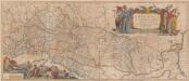
Danubius. Fluvius Europae Maximus. A Fontibus Ad Ostia. Cum omnibus Fluminib. ab utroque latere, in illum fluentibus. [Karte], in: Novus atlas absolutissimus, Bd. 2, S. 238.
1 Karte aus Atlas Janssonius Offizin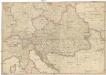
General Karte des Österreichischen Erb-Kaiserthums
1 : 2470000 Evropa jihovýchodní Mollo, Tranquillo T. Mollo
Le Royaume De Hongrie, et les Estats qui en ont esté sujets, et qui sont preventement La Partie Septentrionale De La Tourquie En Europe [Karte], in: Atlas nouveau, contenant toutes les parties du monde [...], Bd. 2, S. 197.
1 Karte aus Atlas Sanson, Nicolas Jaillot, Alexis Hubert und Mortier, Pieter
Karte der politischen Justiz- und Militär- Verwaltungsbezirke im Kaiserthume Oesterreich
Evropa jihovýchodní Schnabel, Jiří Norbert Machek, A.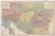
Völker und Sprachen Karte von Österreich und den Unter-Donau-Ländern
1 : 3000000 Rakousko-Uhersko Kiepert, Heinrich Dietrich Reimer
Völker und Sprachen Karte von Österreich und den Unter-Donau-Ländern
1 : 3000000 Evropa střední Kiepert, Heinrich D. Reimer
Völker und Sprachen Karte von Österreich und den Unter-Donau-Ländern
Rakousko-Uhersko Kiepert, Heinrich Riegel, Christoph Dietrich Reimer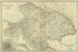
Composite: Austro-Hungarian Monarchy.
1 : 1642000 Johnston, W. & A.K.
Osterreichisch. Ungarische Monarchie.
1 : 3700000 Vogel, C.
Danubius, Fluvius Europae Maximus, A Fontibus Ad Ostia, Cum omnibus Fluminibus, ab utroque latere, in allum defluentibus. [Karte], in: Le théâtre du monde, ou, Nouvel atlas contenant les chartes et descriptions de tous les païs de la terre, Bd. 1, S. 222.
1 Karte aus Atlas Blaeu, Willem Janszoon und Blaeu, Joan Blaeu, Willem Janszoon
Österreich
Neuer Handatlas über alle Theile der Erde Kiepert, Heinrich Verlag von Dietrich Reimer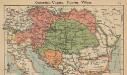
Österreich-Ungarn. Staaten
1 : 9000000 Österreich-Ungarn Politische Geografie