Maps of North Aegean Region

Insularum Archipelagi Septentrionalis seu Maris Aegaei Accurata Delinatio [Karte], in: Novus atlas absolutissimus, Bd. 10, S. 219.
1 Karte aus Atlas Janssonius Offizin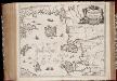
Insvlarvm Archipelagi Septentrionalis seu Maris Aegaei accurata delinatio / autore I. Laurenbergio
1 : 1100000 Annotatie: Jaar van uitg. van kaart ligt in de periode 1650-1662; Origineel is Blad 172 in atlas factice; Verso is blanco; Annotatie geografische gegevens: 4 schaalstokken op de kaart: 7 Mil. Germ., en: 10 Mil. Gall., en: 28 Mil. Ital., en 275 Stadia [Amstelodami] : [Apud Ioannem Ianssonium]
MARIS ÆGÆI, | quod hodie | ARCHIPELAGO | nuncupatur, | PARS SEPTENTRIONALIS.
Auctore | IOANNE LAVRENBERGIO. [Amsterdam : Joan Blaeu]
Balkans 1 000 000e. Constantinople
1 : 1000000 France. Service géographique de l'armée [Paris] : Service géographique de l'armée
Carte De La Mer Mediterranee. XII.
Roux, Joseph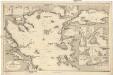
Mittelmeer
1 : 600000 Bulharsko Reichs-Marine-Amt
Schema k dějstvījam Senjavina i Grejga v Archipelagě v 1807 godu
Türkei Seeschlacht Senjavin, Dmitrij Nikolaevič

Übersichtskarte von Mittel - Europa

Gallipoli, Brussa
1 : 750000 Bursa (Turecko) Gstettner, G. K. u. k. Militärgeographisches Institut
Gallipoli, Brussa
1 : 750000 Bursa (Turecko) K. k. militär-geographisches Institut
Übersichtskarte von Mittel - Europa

Saloniki, Seres, Xanthi, Kastro, Pharsalos
1 : 750000 Fársala (Řecko) Budik, A. K. u. k. Militärgeographisches Institut
Salonik, Seres, Xanthi, Kastro, Phersala
1 : 750000 Soluň (Řecko) K. k. militär-geographisches Institut
Sheet 4. 1: 250,000. / dressée par Henri Kiepert d'après ses propres observations et d'autres levées pour la plupart inédites = Map of the western part of Asia Minor
From Specialkarte vom westlichen Kleinasien nach seinen eigenen Reisen und anderen grösstenteils noch unveröffentlichten Routenaufnahmen bearbeitet von Heinrich Kiepert = Carte de la partie occidentale de l 'Asie mineure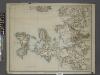
Sheet 7. 1: 250,000. / dressée par Henri Kiepert d'après ses propres observations et d'autres levées pour la plupart inédites = Map of the western part of Asia Minor
From Specialkarte vom westlichen Kleinasien nach seinen eigenen Reisen und anderen grösstenteils noch unveröffentlichten Routenaufnahmen bearbeitet von Heinrich Kiepert = Carte de la partie occidentale de l 'Asie mineure
Plan Afonskago sraženīja Ījunja 19 dnja 1807 goda
Griechenland Athos Seeschlacht
Prolyv Dardanel'skīj i plan sraženīja maīja 10 1807
Türkei Seeschlacht Dardanellen
Estrecho de los Dardaneles, y mar de Mármara
Dardanely (Turecko : průliv) Velazques, J. Brieva, S.
Insular. Aliquot Aegaei Maris Antiqua Descrip.[:] [Lesbos.] [Karte], in: Theatrum orbis terrarum, S. 419.
1 Karte aus Atlas Ortelius, Abraham
Archipelagi Insularum Aliquot Descrip., [Metellino] [Karte], in: Theatrum orbis terrarum, S. 341.
1 Karte aus Atlas Ortelius, Abraham Vrients, Jan Baptista
148. Dardanelles. Bosporus. The World Atlas.
1 : 500000 USSR (Union of Soviet Socialist Republics).
Der Hellespont
1 : 592000 Dardanely (Turecko : průliv) Barbié du Bocage, Jean Denis Anville, Jean-Baptiste Bourguinon d'
Archipelagi Insularum Aliquot Descrip., [Scio] [Karte], in: Theatrum orbis terrarum, S. 246.
1 Karte aus Atlas Ortelius, Abraham
Mitilene Ins. [Karte], in: Gerardi Mercatoris Atlas, sive, Cosmographicae meditationes de fabrica mundi et fabricati figura, S. 523.
1 Karte aus Atlas Mercator, Gerhard Montanus, Petrus
Archipelagi Insularum Aliquot Descrip., [Metellino] [Karte], in: Theatrum orbis terrarum, S. 246.
1 Karte aus Atlas Ortelius, Abraham
Chius Insul. [Karte], in: Gerardi Mercatoris Atlas, sive, Cosmographicae meditationes de fabrica mundi et fabricati figura, S. 523.
1 Karte aus Atlas Mercator, Gerhard Montanus, Petrus
Insular. Aliquot Aegaei Maris Antiqua Descrip.[:] [Lesbos.] [Karte], in: Theatrum orbis terrarum, S. 517.
1 Karte aus Atlas Ortelius, Abraham Vrients, Jan Baptista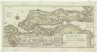
Helespont ou Detroit des Dardanelles
1 : 100000 Dardanely (Turecko : průliv) Maire, Francois Joseph
![Insularum Archipelagi Septentrionalis seu Maris Aegaei Accurata Delinatio [Karte], in: Novus atlas absolutissimus, Bd. 10, S. 219.](https://images-2.georeferencer.com/images/iiif/814627848141/full/,300/0/native.jpg)

