Maps of Izmir
Sheet 7. 1: 250,000. / dressée par Henri Kiepert d'après ses propres observations et d'autres levées pour la plupart inédites = Map of the western part of Asia Minor
From Specialkarte vom westlichen Kleinasien nach seinen eigenen Reisen und anderen grösstenteils noch unveröffentlichten Routenaufnahmen bearbeitet von Heinrich Kiepert = Carte de la partie occidentale de l 'Asie mineure
Archipelagi Insularum Aliquot Descrip., [Scio] [Karte], in: Theatrum orbis terrarum, S. 246.
1 Karte aus Atlas Ortelius, Abraham
Chius Insul. [Karte], in: Gerardi Mercatoris Atlas, sive, Cosmographicae meditationes de fabrica mundi et fabricati figura, S. 523.
1 Karte aus Atlas Mercator, Gerhard Montanus, Petrus
Archipelagi Insularum Aliquot Descrip., [Scio] [Karte], in: Theatrum orbis terrarum, S. 341.
1 Karte aus Atlas Ortelius, Abraham Vrients, Jan Baptista
Insular. Aliquot Aegaei Maris Antiqua Descrip.[:] [Chios.] [Karte], in: Theatrum orbis terrarum, S. 419.
1 Karte aus Atlas Ortelius, Abraham
Insular. Aliquot Aegaei Maris Antiqua Descrip.[:] [Chios.] [Karte], in: Theatrum orbis terrarum, S. 517.
1 Karte aus Atlas Ortelius, Abraham Vrients, Jan Baptista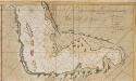
The Gulf of Smirna
Turkey Gerard van Keulen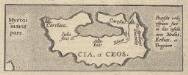
Insular. Aliquot Aegaei Maris Antiqua Descrip.[:] [Cia, et Ceos.] [Karte], in: Theatrum orbis terrarum, S. 517.
1 Karte aus Atlas Ortelius, Abraham Vrients, Jan Baptista
Izobraženije oderžannoj rossijskim flotom pobědy nad tureckim pod predvoditelstvom jego sijatel'stva grafa Aleksěja Grigorjeviča Orlova 24. ijunja/5. ijulja 1770
1 : 137000 Chios, ostrov (Řecko)
Izobraženie oderžannoj rossijskim flotom pobědy nad tureckim pod predvoditel'stvom Jego Sijatel'stva grafa Aleksěja Grigor'jeviča Orlova
1 : 135000 Chios, ostrov (Řecko) Orlov, Alexej Grigorjevič
Mitilene Ins. [Karte], in: Gerardi Mercatoris Atlas, sive, Cosmographicae meditationes de fabrica mundi et fabricati figura, S. 523.
1 Karte aus Atlas Mercator, Gerhard Montanus, Petrus
Archipelagi Insularum Aliquot Descrip., [Metellino] [Karte], in: Theatrum orbis terrarum, S. 341.
1 Karte aus Atlas Ortelius, Abraham Vrients, Jan Baptista
Archipelagi Insularum Aliquot Descrip., [Metellino] [Karte], in: Theatrum orbis terrarum, S. 246.
1 Karte aus Atlas Ortelius, Abraham
Plan morskago sraženija meždu rossijskim flotom pod predvoditel'stvom Jego Sijatel'stva grafa Aleksěja Grigor'jeviča Orlova i ottomanskim ijunja 24./ijulja 5. 1770
Chios, ostrov (Řecko) Orlov, Alexej Grigorjevič
Umgebung von Ephesos
1 : 25000 Efesos (zaniklé město) Schindler, A. des K. u. k. Militärgeographischen Institutes
Umgebung von Ephesos
1 : 25000 Efesos (zaniklé město) Schindler, A. des K. u. k. Militärgeographischen Institutes
Plán města Efesu podle Wooda

Plán města Efesu podle Wooda

Istreblenije ottomanskago flota rossijskoju jeskadroju pod predvoditel'stvom Jego Sijatel'stva grafa Aleksěja Grigor'jeviča Orlova v Česmenskoj gavani v noči na 26 ijunja/7 ijulja 1770
1 : 32600 Chios, ostrov (Řecko) Orlov, Alexej Grigorjevič
Istreblenije ottomanskago flota russijskoju Jeskadroju pod predvolitelstvom jego sijatel'stva grafa Aleksěja Grigorjeviča Orlova v Česmenskoj gavani v noči na 26 ijunja/7 ijulja 1770
1 : 33000 Chios, ostrov (Řecko)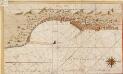
De reede van t eijland Xio of Sio geleegen aen de Oost kand vant eijland in de Archipello
Greece Gerard van Keulen

Insular. Aliquot Aegaei Maris Antiqua Descrip.[:] [Lesbos.] [Karte], in: Theatrum orbis terrarum, S. 419.
1 Karte aus Atlas Ortelius, Abraham
Insular. Aliquot Aegaei Maris Antiqua Descrip.[:] [Lesbos.] [Karte], in: Theatrum orbis terrarum, S. 517.
1 Karte aus Atlas Ortelius, Abraham Vrients, Jan Baptista
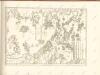
MARIS ÆGÆI, | quod hodie | ARCHIPELAGO | nuncupatur, | PARS SEPTENTRIONALIS.
Auctore | IOANNE LAVRENBERGIO. [Amsterdam : Joan Blaeu]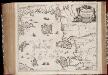
Insvlarvm Archipelagi Septentrionalis seu Maris Aegaei accurata delinatio / autore I. Laurenbergio
1 : 1100000 Annotatie: Jaar van uitg. van kaart ligt in de periode 1650-1662; Origineel is Blad 172 in atlas factice; Verso is blanco; Annotatie geografische gegevens: 4 schaalstokken op de kaart: 7 Mil. Germ., en: 10 Mil. Gall., en: 28 Mil. Ital., en 275 Stadia [Amstelodami] : [Apud Ioannem Ianssonium]
Insularum Archipelagi Septentrionalis seu Maris Aegaei Accurata Delinatio [Karte], in: Novus atlas absolutissimus, Bd. 10, S. 219.
1 Karte aus Atlas Janssonius Offizin
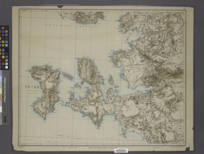
Balkans 1 000 000e. Constantinople
1 : 1000000 France. Service géographique de l'armée [Paris] : Service géographique de l'armée
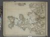
Iles de L'archipel; Dschezaïr
Nouvel atlas physique politique et historique de l'Empire ottoman et des états limitrophes en Europe, en Asie et en Afrique, en quarante feuilles Hellert, J.J. Bellizard, Dufour et Cie