Maps of Autonomous Monastic State of the Holy Mountain

Plan Afonskago sraženīja Ījunja 19 dnja 1807 goda
Griechenland Athos Seeschlacht
Archipelagi Insularum Aliquot Descrip., [Stalimene] [Karte], in: Theatrum orbis terrarum, S. 341.
1 Karte aus Atlas Ortelius, Abraham Vrients, Jan Baptista
Stalimini I. [Karte], in: Gerardi Mercatoris Atlas, sive, Cosmographicae meditationes de fabrica mundi et fabricati figura, S. 523.
1 Karte aus Atlas Mercator, Gerhard Montanus, Petrus
Archipelagi Insularum Aliquot Descrip., [Stalimene] [Karte], in: Theatrum orbis terrarum, S. 246.
1 Karte aus Atlas Ortelius, Abraham
Insular. Aliquot Aegaei Maris Antiqua Descrip.[:] [Lemnos.] [Karte], in: Theatrum orbis terrarum, S. 517.
1 Karte aus Atlas Ortelius, Abraham Vrients, Jan Baptista
Carte des Berges Athos
Athos (Řecko) Grimm, I. L. Siebert, Selmar
Carte de l'Ile de Lemnos
Limnos, ostrov (Řecko)
Insular. Aliquot Aegaei Maris Antiqua Descrip.[:] [Lemnos.] [Karte], in: Theatrum orbis terrarum, S. 419.
1 Karte aus Atlas Ortelius, Abraham
[Dardanellen]
Dardanellen Weltkrieg <1914-1918>
Aegean islands - Lemnos, Samos, Mytilini, Methymna, Series MDR 547
Aegean islands - Lemnos, Samos, Mytilini, Methymna, Series MDR 547. Great Britain. Army. Royal Engineers. Field Survey Company, 512th. [Cairo] : [Survey Directorate, Middle East]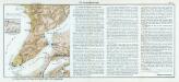
Nr. 14. Die Dardanellenkämpfe. Der Kampfplatz
Dardanellen Weltkrieg <1914-1918>
Ager troianus
Troja
Mediterranean. Aegean. Lemnos Island. Port Mudros.--Porto San Antonio.--Surveyed ... 1916
Mediterranean. Aegean. Lemnos Island. Port Mudros.--Porto San Antonio.--Surveyed ... 1916. Natural scale, 1 : 17,000. London : Admiralty
Gallipoli Peninsula (1915)
[A collection of military maps of the Gallipoli Peninsula] / [G.H.Q. M.E.F.]. Great Britain. Army. Middle East Force. General Headquarters. [Cairo] : G.H.Q. M.E.F.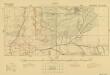
Trench maps of Suvla (provisional) 1:10 000 series (Square 105)
[Trench maps of Suvla (provisional) 1:10 000 series]. Great Britain. Army. Middle East Force. [S.l.] : G.H.Q. M.E.F.
[Romanien]
1 Karte : Kupferdruck ; 18 x 13 cm [Trattner]
Prolyv Dardanel'skīj i plan sraženīja maīja 10 1807
Türkei Seeschlacht Dardanellen
Die Dardanellen
1 : 300000 Dardanellen
Canal des Dardanelles
Nouvel atlas physique politique et historique de l'Empire ottoman et des états limitrophes en Europe, en Asie et en Afrique, en quarante feuilles Hellert, J.J. Bellizard, Dufour et Cie
Der Hellespont
1 : 592000 Dardanely (Turecko : průliv) Barbié du Bocage, Jean Denis Anville, Jean-Baptiste Bourguinon d'
Die Dardanellen oder Hellenspont
1 : 460000 Dardanely (Turecko : průliv)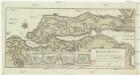
Helespont ou Detroit des Dardanelles
1 : 100000 Dardanely (Turecko : průliv) Maire, Francois Joseph
Der Dardanellen Fortsetzung zum Marmarameer und Nord-Gallipoli
Dardanellen, Halbinsel Gelibolu
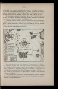
Schema k dějstvījam Senjavina i Grejga v Archipelagě v 1807 godu
Türkei Seeschlacht Senjavin, Dmitrij Nikolaevič
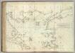
MARIS ÆGÆI, | quod hodie | ARCHIPELAGO | nuncupatur, | PARS SEPTENTRIONALIS.
Auctore | IOANNE LAVRENBERGIO. [Amsterdam : Joan Blaeu]
Insularum Archipelagi Septentrionalis seu Maris Aegaei Accurata Delinatio [Karte], in: Novus atlas absolutissimus, Bd. 10, S. 219.
1 Karte aus Atlas Janssonius Offizin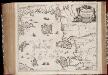
Insvlarvm Archipelagi Septentrionalis seu Maris Aegaei accurata delinatio / autore I. Laurenbergio
1 : 1100000 Annotatie: Jaar van uitg. van kaart ligt in de periode 1650-1662; Origineel is Blad 172 in atlas factice; Verso is blanco; Annotatie geografische gegevens: 4 schaalstokken op de kaart: 7 Mil. Germ., en: 10 Mil. Gall., en: 28 Mil. Ital., en 275 Stadia [Amstelodami] : [Apud Ioannem Ianssonium]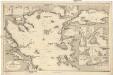
Mittelmeer
1 : 600000 Bulharsko Reichs-Marine-Amt
Balkans 1 000 000e. Constantinople
1 : 1000000 France. Service géographique de l'armée [Paris] : Service géographique de l'armée