Maps of Kent

Suthsexia. Vernacule Sussex. [Karte], in: Novus atlas absolutissimus, Bd. 7, S. 137.
1 Karte aus Atlas Janssonius Offizin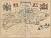
Suthsexia; Vernacule Sussex. [Karte], in: Theatrum orbis terrarum, sive, Atlas novus, Bd. 4, S. 202.
1 Karte aus Atlas Blaeu, Joan Blaeu, Willem Janszoon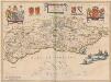
Suthsexia; Vernacule Sussex. [Karte], in: Theatrum orbis terrarum, sive, Atlas novus, Bd. 4, S. 202.
1 Karte aus Atlas Blaeu, Joan Blaeu, Willem Janszoon
Suthsexia; Vernacule, Sussex. [Karte], in: Le théâtre du monde, ou, Nouvel atlas contenant les chartes et descriptions de tous les païs de la terre, Bd. 4, S. 180.
1 Karte aus Atlas Blaeu, Willem Janszoon und Blaeu, Joan Blaeu, Willem Janszoon
Suthsexia vernacule Sussex
1 : 240000 Amstelodami : apud Joannem Janssonium
England and Wales[OS civil air edition]
Ordnance Survey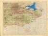
Ordnance Survey of England and Wales (Aeronautical map)
Great Britain. War Office. General Staff. Geographical Section [London] : [Air Ministry],
Sheet 12 England, South East & London, uit: Maps of England & Wales : scale 4 miles to 1 inch / Ordnance Survey
1 : 253440 titelvariant: Maps of England and Wales; Annotatie: Titel op cassette; Met bladoverzicht op de achterzijde van de cassette; Annotatie geografische gegevens: Hoogtelijneninterval 200 ft Ordnance Survey, United Kingdom Southampton : Ordnance Survey Office
SVTHSEXIA, | Vernacule | SUSSEX.
[Amsterdam : Joan Blaeu]
Rainham reverse
1 : 21120 This rough triangulation diagram of southern England was draughted in the field to augment the angle and distance measurements recorded in the Ordnance Survey Field Books. Angular observations were made using a theodolite to measure the relative height of the land and plot individual topographical features. Triangulation points were usually at sites elevated above the surrounding landscape, often hilltops and church towers.

Suthsexia vernacule Sussex
1 Karte : Kupferdruck ; 36 x 49 cm Valck; Schenk apud Gerardum Valk et Petrum Schenk
Svthsexia; vernacule Svssex
1 Karte : Kupferdruck ; 37 x 51 cm Blaeu Joan Blaeu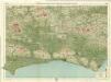
Sussex, Sheet 32 - Bartholomew's "Half Inch to the Mile Maps" of England & Wales
1 : 126720 Topographic maps Bartholomew, John George John Bartholomew & Co
Surria vernacule Surrey
1 : 220000 [Amstelodami] : [apud Joannem Janssonium]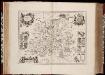
Surria vernacule Surrey / [Joannes Janssonius]
1 : 200000 Annotatie: Oorspr. verschenen in: Ioannis Ianssonii Novus atlas ... - Amstelodami : apud Iohannem Ianssonium, 1646; Origineel is Blad 26 in atlas factice Janssonius, Joannes (jr.) (1588-1664) [Amsterdam : Joannes Janssonius]
Surria. Vernacule Surrey. [Karte], in: Novus atlas absolutissimus, Bd. 7, S. 148.
1 Karte aus Atlas Janssonius Offizin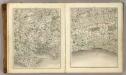
Sheets 15-16. (Cary's England, Wales, and Scotland).
1 : 360000 Cary, John, ca. 1754-1835
Surria Vernacule Surrey. [Karte], in: Theatrum orbis terrarum, sive, Atlas novus, Bd. 4, S. 195.
1 Karte aus Atlas Blaeu, Joan Blaeu, Willem Janszoon
Surria Vernacule Surrey. [Karte], in: Theatrum orbis terrarum, sive, Atlas novus, Bd. 4, S. 195.
1 Karte aus Atlas Blaeu, Joan Blaeu, Willem Janszoon
Surria Vernacule Surrey. [Karte], in: Le théâtre du monde, ou, Nouvel atlas contenant les chartes et descriptions de tous les païs de la terre, Bd. 4, S. 173.
1 Karte aus Atlas Blaeu, Willem Janszoon und Blaeu, Joan Blaeu, Willem Janszoon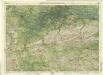
Surrey, Sheet 30 - Bartholomew's "Half Inch to the Mile Maps" of England & Wales
1 : 126720 Topographic maps Bartholomew, John George John Bartholomew & Co
SVRRIA | Vernacule | SVRREY.
[Amsterdam : Joan Blaeu]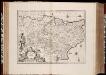
Cantium vernacule Kent / [Joannes Janssonius]
1 : 200000 Annotatie: Oorspr. verschenen in: Ioannis Ianssonii Atlas Novus ... - Amstelodami : apud Iohannem Ianssonium, 1646; Origineel is Blad 29 in atlas factice Janssonius, Joannes (jr.) (1588-1664) Amstelodami : apud Ioannem Ianssonium
Cantium Vernacule Kent. [Karte], in: Novus atlas absolutissimus, Bd. 7, S. 122.
1 Karte aus Atlas Janssonius Offizin
Kent
Stent, Peter, Symonson, Philip and Whitwell, Charles Ordnance Survey
Cantium vernacule Kent
1 : 130000 Amstelodami : apud Joannem Janssonium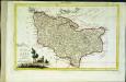
Provincia di Kent
1 Karte : Kupferdruck ; 18 x 29 cm Zatta; Zuliani; Pitteri presso Antonio Zatta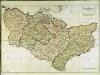
A map of the county of Kent
1 Karte : Kupferdruck ; 49 x 70 cm Kitchin; Dury; Andrews; Herbert A. Dury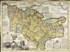
An accurate map of the county of Kent
1 Karte : Kupferdruck ; 50 x 69 cm Bowen; Hinton sold by J. Hinton at the Kings Arms in St. Pauls Church Yard
![Suthsexia. Vernacule Sussex. [Karte], in: Novus atlas absolutissimus, Bd. 7, S. 137.](https://images-2.georeferencer.com/images/iiif/250008142671/full/,300/0/native.jpg)

