Maps of Surrey
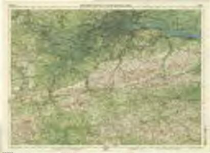
Surrey, Sheet 30 - Bartholomew's "Half Inch to the Mile Maps" of England & Wales
1 : 126720 Topographic maps Bartholomew, John George John Bartholomew & Co
SVRRIA | Vernacule | SVRREY.
[Amsterdam : Joan Blaeu]
Surria. Vernacule Surrey. [Karte], in: Novus atlas absolutissimus, Bd. 7, S. 148.
1 Karte aus Atlas Janssonius Offizin
Surria Vernacule Surrey. [Karte], in: Le théâtre du monde, ou, Nouvel atlas contenant les chartes et descriptions de tous les païs de la terre, Bd. 4, S. 173.
1 Karte aus Atlas Blaeu, Willem Janszoon und Blaeu, Joan Blaeu, Willem Janszoon
Surria Vernacule Surrey. [Karte], in: Theatrum orbis terrarum, sive, Atlas novus, Bd. 4, S. 195.
1 Karte aus Atlas Blaeu, Joan Blaeu, Willem Janszoon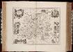
Surria vernacule Surrey / [Joannes Janssonius]
1 : 200000 Annotatie: Oorspr. verschenen in: Ioannis Ianssonii Novus atlas ... - Amstelodami : apud Iohannem Ianssonium, 1646; Origineel is Blad 26 in atlas factice Janssonius, Joannes (jr.) (1588-1664) [Amsterdam : Joannes Janssonius]
Surria Vernacule Surrey. [Karte], in: Theatrum orbis terrarum, sive, Atlas novus, Bd. 4, S. 195.
1 Karte aus Atlas Blaeu, Joan Blaeu, Willem Janszoon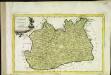
Provincia di Surrey
1 Karte : Kupferdruck ; 18 x 29 cm Zatta presso Antonio Zatta
An accurate map of the county of Surrey
1 Karte : Kupferdruck ; 51 x 69 cm Bowen; Hinton sold by I. Hinton at the Kings Arms in St Pauls Church Yard
Svrria vernacule Svrrey
1 Karte : Kupferdruck ; 36 x 48 cm Blaeu Joan Blaeu
Environs of London.
1 : 93000 Colton, G.W.
A TOPGRAPHICAL MAP OF THE COUNTRY TWENTY MILES ROUND LONDON
In the second half of the18th century, the introduction of turnpike roads and the increased coach-traffic in and out of London contributed to the popularity of the maps of the countryside around the capital. The title of this circular map runs along the top, with points on the compass marked on the border. A list of main roads to and from London is provided at bottom left, with a key at bottom right and scale bar below the plan. Faden, William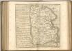

London SW - OS One-Inch Map
1 : 63360 Topographic maps Ordnance Survey Ordnance Survey
A NEW and CORRECT MAP of the COUNTRIES TWENTY MILES Round LONDON.
In the second half of the18th century, the introduction of turnpike roads and the increased coach-traffic in and out of London contributed to the popularity of the maps of the countryside around the capital. This map was published in Henry Chamberlain's 1770 'A New and Compleat History and Survey of the Cities of London and Westminster.' The map's title features along the top, with a scale bar and explanatory note below the plan, and border divided in degrees of latitude and longitude. Churches, hills and other architectural or geographical landmarks are indicated by symbols. Market towns are marked by stars. Bowen, Thomas
London SE - OS One-Inch Map
1 : 63360 Topographic maps Ordnance Survey Ordnance Survey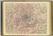
Outer London.
1 : 106065 Stanford, Edward
Public open spaces
1 : 189000 Waterlow & sons
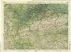
England and Wales [OS of]
Ordnance Survey
Leigh's new map of the environs of London
1 : 247000 drawn and engraved by Sidy. Hall, 14 Bury St., Bloomsby London : Leigh
Delineatio ac finitima regio Magnae Brittaniae metropoleos Londini
1 : 120000 ad novissimam Normam repraesentata et excusa a T. Conr. Lotter, Augustano Chalcogr. Et Geogr. [Augsburg] : [Tobias Konrad Lotter]
An accurate MAP of the Country TWENTY MILES round LONDON. From GRAVESEND to WINDSOR East and West, and from ST. ALBANS to WESTERHAM North and South with the CIRCUIT of the PENNY POST
In the second half of the18th century, the introduction of turnpike roads and the increased coach-traffic in and out of London contributed to the popularity of the maps of the countryside around the capital. The title of this plan runs along the top, with borders divided in degrees of latitude and longitude, county boundaries outlined in colour and the circuit of the Penny Postmarked in red. Before William Dockwra set up the Penny Post in 1680, there was no local delivery of letters in London, except by private courier. Dockwra opened seven sorting offices and hundreds of receiving houses. Letters were delivered to addresses in London for the charge of a penny, paid by the sender. An extra penny was charged for deliveries in the London Country area within ten miles of the city. In 1682, the Post Office took over the running of the service. Cary, John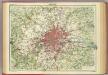
London.
1 : 126720 John Bartholomew & Co.
Map showing the general Boundaries of the GENERAL POST DELIVERY; of the FOREIGN DELIVERY; of the Town Delivery of the Two penny Post Department; and of the COUNTRY DELIVERY
This map of the area round London was produced by order of the House of Commons for the 21st report of the Commissioners of Revenue Inquiry. The map's title is at top right with areas of various postal delivery services highlighted in colour. Basire, James
Delineatio ac finitima regio Magnæ Brittaniæ metropoleos Londini
1 Karte : Kupferdruck ; 48 x 57 cm Lotter Tobias Konrad Lotter
Les environs de Londres
1 Karte : Kupferdruck ; 47 x 53 cm chez I. Côvens et C. Mortier
Delineatio ac finitima regio Magnae Brittaniae metropoleos Londini
Londýn (Anglie) Seutter, Matthäus a Matt. Seutter
Map of Forests around Windsor
Map of the forests around Windsor from "A Description of the Honour of Windesor", John Norden's survey of Windsor. The title page states that the survey was "taken and performed by the perambulation view and delineation of John Norden In Anno 1607". The plans are the result of a survey conducted on foot by Norden. The maps in this volume show communication routes, individual buildings, field boundaries and parkland along with details of wildlife and human activity, such as stags in Windsor Park and people boating on the Thames. The scale at which the maps are presented varies throughout the volume, with feet, perches and miles being the units of measurement recorded by a scale bar. John Norden is best known for his work "Speculum Britainiae", literally a "Mirror of Britain", which in its attempt to include the road names and town plans, lacking on many county maps of the period, was a direct ancestor of the modern A-Z. As well as producing several county maps in the 1590s, Norden worked as a land surveyor producing surveys for landowners and was the author of a work which outlines principles of surveying, known as the "Surveyor's Dialogue". Norden, John
Environs of London
1 : 63360 W.H. Smith & Son W. H. Smith & Son