Maps of Appalachian Mountains

Nova Belgica Et Anglia Nova [Karte], in: Novus atlas absolutissimus, Bd. 6, S. 202.
1 Karte aus Atlas Janssonius Offizin
Nova Anglia Novum Belgium et Virginia [Karte], in: Gerardi Mercatoris et I. Hondii Newer Atlas, oder, Grosses Weltbuch, Bd. 2, S. 386.
1 Karte aus Atlas Mercator, Gerhard und Hondius, Jodocus Jansson, Jan
Carte du theatre de la guerre présente en Amerique
1 : 5000000 Nová Anglie Denis, L. Basset, André Basset
Carte du theatre de la guerre presente en Amerique dressée d'après les nouvelles cartes anglaises / par L. Denis, géographe et auteur du conducteur français.
from Charts and maps L. Denis,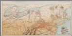
[Recto], uit: Reading railroad system and connections
Buffalo, N.Y. : The Matthews-Northrup Co.
Partie de l'Amérique septentrionale, qui comprend le cours de l'Ohio, la Nlle. Angleterre, la Nlle York, le New Jersey, la Pensylvanie, le Maryland, la Virginie, la Caroline / par le Sr. Robert de Vaugondy, géographe ordinaire du roi ; M. C. Haussard, fe
from Charts and maps
Map of the United States of America.; Carey's general atlas, improved and enlarged: being a collection of maps of the world and quarters, their principal empires, kingdoms, &c.
from Carey's general atlas, improved and enlarged : being a collection of maps of the world and quarters, their principal empires, kingdoms, &c. Carey, Mathew; Manning, Thomas S.,
Newengland and New York.
from An epitome of Mr. John Speed's Theatre of the empire of Great Britain, and of his Prospect of the most famous parts of the world : in this new edition are added, the descriptions of His Majesties dominions abroad, viz. New England, New York, ... Carolina, Florida, ... Virginia, Maryland, ... Jamaica, Barbados, ... as also the empire of the Great Mogol, with the rest of the East Indies, ... the empire of Russia, with their respective descriptions.
Virginia, Marylandia et Carolina in America septentrionali Britannorum industria excultae / repraesentatae à Ioh. Bapt. Homann, S.C.M. Geog.
from Parts
Map of the United States of North America / compiled from the latest and most authentic information by David H. Vance ; engraved by J.H. Young.
From Whole
United States of America

Les États Unis de l'Amérique septentrionale
1 : 6050000 Spojené státy americké-oblast východní Bonne, Rigobert André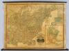
United States.
1 : 1964160 Woodbridge, J.L.
Northern provinces of the United States / drawn & engraved for Thomson's New general atlas, 1817 ; Hewitt Sc. ...
from Charts and maps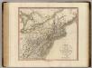
New York, Vermont, New Hampshire, etc.
1 : 2800000 Cary, John, ca. 1754-1835
A map of the travels of George Washington
1 : 2500000 Boston (Massachusetts : oblast) National Geographic Society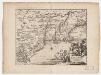
Novi Belgii, quod nunc Novi Jorck vocatur, Novae q[ue] Angliae & partis Virginiae : accuratissima et novissima delineatio
1 : 3500000 Montanus, Arnoldus, 1625?-1683 J. Meurs
Mappa aestivarum insularum alias Barmudas dictarum, ad Ostia Mexicani aestuarij jacentium in latitudine graduum 32 minutorum 25. Ab Anglia Londino scilicet versus Libonotum 3300 Miliaribus Anglicanis, et a Roanoack (qui locus est in Virginia) versus ...
1 : 3400000
Map of the United States of America.
1 : 5800000 Melish, John
Map of the United States.
1 : 6750000 Scott, Joseph
(United States) East of Chicago.
1 : 3802000 Rand McNally and Company
Nova tabula geographica complectens borealiorem Americae partem : in qua exacte delineatae sunt Canada sive Nova Francia, Nova Scotia, Nova Anglia, Novum Belgium, Pensylvania, Virginia, Carolina et Terra Nova : cum omnibus littorum pulvinorumque profundi
from John H. Levine Collection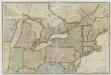
New travelling and commercial map of the Canadas: from the Sault of St. Marie to the river Saguenay, and a large section of the United States of America / compiled from the latest surveys and most approved authorities ... by his obliged obedient humble servant David Taylor, R.N., March 1834; engraved by S. Stiles & Co.
from Parts David Taylor; S. Stiles & Co.,
Der Nördliche Theil der Vereinigten Staaten von Nord America
Hand-Atlas über alle Theile der Erde nach dem neuesten Zustande und über das Weltgebäude Stieler, Adolf bei Justus Perthes
Partie de l'Amerique septentrionale, qui comprend le cours de l'Ohio, la Nlle. Angleterre, la Nlle. York, le New Jersey, la Pensylvanie, le Maryland, la Virginie, la Caroline / par le Sr. Robert de Vaugondy, géographe; Groux.
from John H. Levine Collection Robert de Vaugondy,
Map of the United States of America / Gridley, sc.
from Whole Gridley,
Map of the United States of America / J. Melish, del.; H.S. Tanner, sc.
from Whole John Melish; Henry S. Tanner,

Canada, Louisiane et terres angloises / par le Sr. d'Anville ...
from Parts
![Nova Belgica Et Anglia Nova [Karte], in: Novus atlas absolutissimus, Bd. 6, S. 202.](https://images-2.georeferencer.com/images/iiif/537084201577/full/,300/0/native.jpg)

