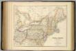
Maps of Appalachian Mountains

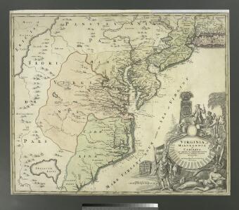
Virginia, Marylandia et Carolina in America septentrionali Britannorum industria excultae / repraesentatae à Ioh. Bapt. Homann, S.C.M. Geog.
from Parts
Nova Belgica Et Anglia Nova [Karte], in: Novus atlas absolutissimus, Bd. 6, S. 202.
1 Karte aus Atlas Janssonius Offizin
Novi Belgii, quod nunc Novi Jorck vocatur, Novae q[ue] Angliae & partis Virginiae : accuratissima et novissima delineatio
1 : 3500000 Montanus, Arnoldus, 1625?-1683 J. Meurs
Les États Unis de l'Amérique septentrionale
1 : 6050000 Spojené státy americké-oblast východní Bonne, Rigobert André
New York, Vermont, New Hampshire, etc.
1 : 2800000 Cary, John, ca. 1754-1835
Nova tabula geographica complectens borealiorem Americae partem : in qua exacte delineatae sunt Canada sive Nova Francia, Nova Scotia, Nova Anglia, Novum Belgium, Pensylvania, Virginia, Carolina et Terra Nova : cum omnibus littorum pulvinorumque profundi
from John H. Levine Collection
Map of the United States of North America / compiled from the latest and most authentic information by David H. Vance ; engraved by J.H. Young.
From Whole
Der Nördliche Theil der Vereinigten Staaten von Nord America
Hand-Atlas über alle Theile der Erde nach dem neuesten Zustande und über das Weltgebäude Stieler, Adolf bei Justus Perthes
D'Engelze volkplanting in Virginie / door Iohan Smith bezogt en verder uytgeset = Peuplade des Anglois dans la Virginie / visitée et augmentée par Jean Smith, suivant qu il l'a décrite lui-même dans son voyage ; rectifiée sur de nouvelles observations fa
from Virginia
Nordost-Staaten der Union.
1 : 5000000 Andree, Richard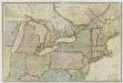
New travelling and commercial map of the Canadas: from the Sault of St. Marie to the river Saguenay, and a large section of the United States of America / compiled from the latest surveys and most approved authorities ... by his obliged obedient humble servant David Taylor, R.N., March 1834; engraved by S. Stiles & Co.
from Parts David Taylor; S. Stiles & Co.,
Pas caerte van Nieu Nederlandt en de Engelsche Virginies van Cabo Cod tot Cabo Canrick.
from De zee-atlas, ofte, Water-weereld : waer in vertoont werden alle de zee-kusten van het bekende des aerd-bodems : seer dienstigh voor alle heeren en kooplieden, als oock voor alle schippers en stuurlieden / gesneden, gedruckt en uytgegeven t'Amsteldam.
A map of the travels of George Washington
1 : 2500000 Boston (Massachusetts : oblast) National Geographic Society

[Côte de York-town à Boston : Marches de l'armée].
from Histoire des troubles de l'Amérique anglaise, ecrite sur les mémoires les plus authentiques ... par François Soulés ...
NOVA | BELGICA | ET | ANGLIA | NOVA.
[Amsterdam : Joan Blaeu]
A new map of the most considerable plantations of the English in America / Sutton Nicholls, sculp.
from Parts Sutton Nicholls,
Belgii novi, angliae novae, et partis Virginiae : novissima delineatio
1 : 2450000 Jansson, Jan, 1588-1664 Prostant ... apud Petrum Schenk, et Gerardum Valk
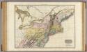
Northern provinces of the United States / drawn & engraved for Thomson's New general atlas, 1817 ; Hewitt Sc. ...
from Parts
Nieuwe en nauwkeurige kaart van een gedeelte van Noord Amerika : behelzende Nieuw Engeland, New York, Pennsylvania, New Jersey, Connecticut, Rhode Island, een stuk van Virginia, Kanada en Halifax, ter opheldering der reizen van den Heer P. Kalm / C.J. de
from Reis door Noord Amerika, gedaan door den Heer Pieter Kalm ... Vercierd met koperen platen ...
130-31. Ohio, Penn., N.Y., Vt., N.H., W.Va., Va., N.C.
1 : 3000000 Touring club italiano
Northern provinces of the United States / drawn & engraved for Thomson's New general atlas, 1817 ; Hewitt Sc. ...
from Charts and maps
United States of America, northern part.
1 : 2100000 Pinkerton, John, 1758-1826
Part of North America: comprehending the course of Ohio, New England, New York, New Jersey, Pennsylvania, Maryland, Virginia, Carolina & Georgia.
from Parts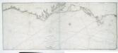
To the independent mariners of America: this chart of their coast from Savannah to Boston is most respectfully dedicated / by their much obliged & grateful servant, W. Heather; engraved by J. Stephenson.
from Charts and maps J. Stephenson; W. Heather,
Nova tabula geographica complectens Borealiorem Americae partem, in qua exacte delineatae sunt Canada sive Nova Francia, Nova Scotia, Nova Anglia, Novum Belgium, Pensylvania, Virginia, Carolina, et Terra Nova, cum omnibus littorum pulvinorumque profunditatibus
1 : 4000000 â Nicolao Visscher Luggardus van Anse schulp. Amstlodami : nunc apud Petrus Schenk Junior
Partie de l'Amerique septentrionale, qui comprend le cours de l'Ohio, la Nlle. Angleterre, la Nlle. York, le New Jersey, la Pensylvanie, le Maryland, la Virginie, la Caroline / par le Sr. Robert de Vaugondy, géographe; Groux.
from John H. Levine Collection Robert de Vaugondy,
Nördlicher Theil der Vereinigten Staaten
Stieler's Hand-Atlas Stieler, Adolf bei Justus Perthes