Maps of Appalachian Mountains

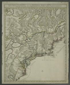
Nova tabula geographica complectens borealiorem Americae partem : in qua exacte delineatae sunt Canada sive Nova Francia, Nova Scotia, Nova Anglia, Novum Belgium, Pensylvania, Virginia, Carolina et Terra Nova : cum omnibus littorum pulvinorumque profundi
from John H. Levine Collection
Partie de l'Amérique septentrionale, qui comprend le cours de l'Ohio, la Nlle. Angleterre, la Nlle York, le New Jersey, la Pensylvanie, le Maryland, la Virginie, la Caroline / par le Sr. Robert de Vaugondy, géographe ordinaire du roi ; M. C. Haussard, fe
from Charts and maps
Newengland and New York.
from An epitome of Mr. John Speed's Theatre of the empire of Great Britain, and of his Prospect of the most famous parts of the world : in this new edition are added, the descriptions of His Majesties dominions abroad, viz. New England, New York, ... Carolina, Florida, ... Virginia, Maryland, ... Jamaica, Barbados, ... as also the empire of the Great Mogol, with the rest of the East Indies, ... the empire of Russia, with their respective descriptions.
Etats Unis Flle. N.E.
1 : 5000000 Vivien St Martin, L.
Map of the United States of North America / compiled from the latest and most authentic information by David H. Vance ; engraved by J.H. Young.
From Whole
Nieuwe en nauwkeurige kaart van een gedeelte van Noord Amerika : behelzende Nieuw Engeland, New York, Pennsylvania, New Jersey, Connecticut, Rhode Island, een stuk van Virginia, Kanada en Halifax, ter opheldering der reizen van den Heer P. Kalm / C.J. de
from Reis door Noord Amerika, gedaan door den Heer Pieter Kalm ... Vercierd met koperen platen ...
Copy of a map attached to Govr. Colden's History of the Five Indian Natio[ns] : printed in London, A.D. MDCCXLVII.
from Parts
Northern provinces of the United States / drawn & engraved for Thomson's New general atlas, 1817 ; Hewitt Sc. ...
from Parts
Canada.
1 : 7300000 Lucas, Fielding Jr.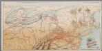
[Recto], uit: Reading railroad system and connections
Buffalo, N.Y. : The Matthews-Northrup Co.
Nova tabula geographica complectens Borealiorem Americae partem, in qua exacte delineatae sunt Canada sive Nova Francia, Nova Scotia, Nova Anglia, Novum Belgium, Pensylvania, Virginia, Carolina, et Terra Nova, cum omnibus littorum pulvinorumque profunditatibus
1 : 4000000 â Nicolao Visscher Luggardus van Anse schulp. Amstlodami : nunc apud Petrus Schenk Junior
Canada &c.
1 : 7350000 Lucas, Fielding Jr.
Pennsylvania and New Jersey.
from Parts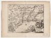
Novi Belgii, quod nunc Novi Jorck vocatur, Novae q[ue] Angliae & partis Virginiae : accuratissima et novissima delineatio
1 : 3500000 Montanus, Arnoldus, 1625?-1683 J. Meurs
Map of the Seat of War in North America.
1 : 4118400 Melish, John
Map of the Seat of War in North America.
1 : 4118400 Melish, John
N. section U.S.
1 : 4200000 Melish, John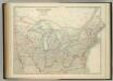
United States of North America (North East Sheet).
1 : 3984000 Johnston, W. & A.K.
Northern provinces of the United States / drawn & engraved for Thomson's New general atlas, 1817 ; Hewitt Sc. ...
from Charts and maps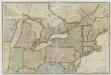
New travelling and commercial map of the Canadas: from the Sault of St. Marie to the river Saguenay, and a large section of the United States of America / compiled from the latest surveys and most approved authorities ... by his obliged obedient humble servant David Taylor, R.N., March 1834; engraved by S. Stiles & Co.
from Parts David Taylor; S. Stiles & Co.,
Commercial Map, East of Chicago.
1 : 3950000 Rand McNally and Company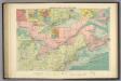
American Atlantic ports N.
1 : 5000000 Philip, George
Virginia, Marylandia et Carolina in America septentrionali Britannorum industria excultae / repraesentatae à Ioh. Bapt. Homann, S.C.M. Geog.
from Parts
Vereinigte Staaten Von Nord-Amerika In 6 Blattern, Bl. 3.
1 : 3700000 Petermann, A.
130-31. Ohio, Penn., N.Y., Vt., N.H., W.Va., Va., N.C.
1 : 3000000 Touring club italiano
(United States) East of Chicago.
1 : 3802000 Rand McNally and Company
Map of the seat of war in North America / J. Melish del.; H. S. Tanner dirext.
from Parts John Melish; Henry S. Tanner,
[Die Vereinigten Staaten von Amerika in 6 Blättern, Blatt 3]
Adolf Stieler's Handatlas über alle Theile der Erde und über das Weltgebäude Stieler, Adolf Justus Perthes
[Die Vereinigten Staaten von Nord-Amerika, Blatt 3]
Handatlas über alle Theile der Erde und über das Weltgebäude Stieler, Adolf Justus Perthes