Maps of Ceredigion

Ceretica; sive Cardiganensis Comitatus; Anglis Cardigan Shire. [Karte], in: Theatrum orbis terrarum, sive, Atlas novus, Bd. 4, S. 421.
1 Karte aus Atlas Blaeu, Joan Blaeu, Willem Janszoon
Ceretica; sive Cardiganensis Comitatus; Anglis Cardigan Shire. [Karte], in: Theatrum orbis terrarum, sive, Atlas novus, Bd. 4, S. 421.
1 Karte aus Atlas Blaeu, Joan Blaeu, Willem Janszoon
Ceretica; sive Cardiganensis Comitatus; Anglis Cardigan Shire. [Karte], in: Novus atlas absolutissimus, Bd. 7, S. 395.
1 Karte aus Atlas Janssonius Offizin
CERETICA; | sive | CARDIGANensis | Comitatus; Anglis | CARDIGAN SHIRE.
[Amsterdam : Joan Blaeu]
Ceretica; sive Cardiganensis Comitatus; Anglis Cardigan Shire. [Karte], in: Le théâtre du monde, ou, Nouvel atlas contenant les chartes et descriptions de tous les païs de la terre, Bd. 4, S. 363.
1 Karte aus Atlas Blaeu, Willem Janszoon und Blaeu, Joan Blaeu, Willem Janszoon
Ceretica, sive Cardiganensis Comitatus, anglis Cardigan Shire
1 : 460000 Amstelodami : apud Joannem Janssonium
RADNOR, BREKNOK, Cardigan et Caermarden
This is a map of Radnor, Brecknock, Cardigan and Caermarthen by Christopher Saxton which dates from 1578. It forms part of an atlas that belonged to William Cecil Lord Burghley, Elizabeth I’s Secretary of State. Burghley used this atlas to illustrate domestic matters. This map is actually a proof copy of one which forms part of Christopher Saxton’s Atlas of England and Wales. This atlas was first published as a whole in 1579. It consists of 35 coloured maps depicting the counties of England and Wales. The atlas is of great significance to British cartography as it set a standard of cartographic representation in Britain and the maps remained the basis for English county mapping, with few exceptions, until after 1750. During the reign of Elizabeth I map use became more common, with many government matters referring to increasingly accurate maps with consistent scales and symbols, made possible by advances in surveying techniques. Illustrating the increasing use of maps in government matters, Lord Burghley, who had been determined to have England and Wales mapped in detail from the 1550s, selected the cartographer Christopher Saxton to produce a detailed and consistent survey of the country. The financier of the project was Thomas Seckford, Master of Requests at the Court of Elizabeth I, whose arms appear, along with the royal crest, on each map. Burghley has annotated this map, adding place names. At this time England was under threat of invasion from Catholic Spain, a threat which culminated in the events of the Spanish Armada. Defence of the realm depended on a good geographic and topographic knowledge, explaining Burghley's use of maps and his annotation of them. The map was engraved by one of a team of seven English and Flemish engravers employed to produce the copper plates for the atlas, although the individual engraver is not noted. Saxton, Christopher William Cecil, Lord Burghley
RADNOR BREKNOK Cardigan et Caermarden
This map of Radnor,Cardigan, Carmarthenshire and Brecknonshire, from the 1583 edition of the Saxton atlas of England and Wales.This atlas was first published as a whole in 1579. It consists of 35 coloured maps depicting the counties of England and Wales. The atlas is of great significance to British cartography as it set a standard of cartographic representation in Britain and the maps remained the basis for English county mapping, with few exceptions, until after 1750. During the reign of Elizabeth I map use became more common, with many government matters referring to increasingly accurate maps with consistent scales and symbols, made possible by advances in surveying techniques. Illustrating the increasing used of maps in government matters, Lord Burghley, Elizabeth I’s Secretary of State, who had been determined to have England and Wales mapped in detail from the 1550s, selected the cartographer Christopher Saxton to produce a detailed and consistent survey of the country. The financier of the project was Thomas Seckford Master of Requests at the Court of Elizabeth I, whose arms appear, along with the royal crest, on each map. Saxton, Christopher Ryther, Augustine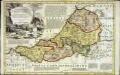
An accurate map of Cardigan Shire
1 Karte : Kupferdruck ; 33 x 52 cm Kitchin; Tinney John Tinney
Ceretica; sive Cardiganensis comitatus; anglis Cardigan Shire
1 Karte : Kupferdruck ; 36 x 48 cm Blaeu Joan Blaeu
Sheets 29-30. (Cary's England, Wales, and Scotland).
1 : 360000 Cary, John, ca. 1754-1835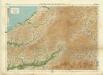
Carmarthen, Sheet 22 - Bartholomew's "Half Inch to the Mile Maps" of England & Wales
1 : 126720 Topographic maps Bartholomew, John George John Bartholomew & Co
South Wales and the border in the 14th century
Rees, William Ordnance Survey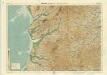
Aberystwyth, Sheet 16 - Bartholomew's "Half Inch to the Mile Maps" of England & Wales
1 : 126720 Topographic maps Bartholomew, John George John Bartholomew & Co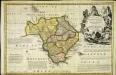
An accurate map of Radnor Shire
1 Karte : Kupferdruck ; 33 x 51 cm Kitchin; Tinney John Tinney
Radnoria comitatvs
1 Karte : Kupferdruck ; 37 x 48 cm Blaeu Joan Blaeu
Radnoria Comitatus Radnor Shire. [Karte], in: Theatrum orbis terrarum, sive, Atlas novus, Bd. 4, S. 398.
1 Karte aus Atlas Blaeu, Joan Blaeu, Willem Janszoon
Radnoriensis Comitatus Vulgo The Countie of Radnor. [Karte], in: Novus atlas absolutissimus, Bd. 7, S. 381.
1 Karte aus Atlas Janssonius Offizin
Radnoria Comitatus Radnor Shire. [Karte], in: Le théâtre du monde, ou, Nouvel atlas contenant les chartes et descriptions de tous les païs de la terre, Bd. 4, S. 344.
1 Karte aus Atlas Blaeu, Willem Janszoon und Blaeu, Joan Blaeu, Willem Janszoon
Radnoria Comitatus Radnor Shire. [Karte], in: Theatrum orbis terrarum, sive, Atlas novus, Bd. 4, S. 398.
1 Karte aus Atlas Blaeu, Joan Blaeu, Willem Janszoon
Aberystwyth - OS One-Inch Map
1 : 63360 Topographic maps Ordnance Survey Ordnance Survey
Llandovery - OS One-Inch Map
1 : 63360 Topographic maps Ordnance Survey Ordnance Survey
Cardigan - OS One-Inch Map
1 : 63360 Topographic maps Ordnance Survey Ordnance Survey
Newcastle-in-Emlyn
1 : 31680 This plan of North Carmarthenshire shows the Teify Valley at the top, with settlements, enclosed farmland and densely wooded areas dominating the valley landscape. Mynydd Llanllwni and Pencarreg depicted at the bottom of the sheet form the valley's distinctive backdrop. Rising steeply from the valley, the rounded and open plateau summit of Mynydd Llanllwni contains extensive areas of moorland and common land, represented by open dots on the plan. Budgen, Thomas
Cardiganshire
1 : 31680 This drawing is formally titled. Its scale is noted and the surveyed area recorded as 205.6742 square miles. Archaeological sites are named in gothic script. Colour washes depicting relief are combined with numerical annotations ('spot heights') in red and black ink giving the heights of the hills. Figures in red represent trigonometrically ascertained altitudes whereas those in black are estimates. On the top left margin a note, dated 1st April 1822, from draughtsman Robert Dawson reads: "Cws yr ychen Bannog, is an ancient Bank said to run from sea to sea. It could not be traced in this survey beyond Carn Cron. The Rev John Williams of Ystrad Meyric supposes it may be a British Road, or a Boundary between two tribes of the Britons". Dawson, Robert
Lampeter
1 : 31680 This plan of Cardigan Bay and part of the county of Cardiganshire shows Lampeter and other settlements at lower left along the River Teify Valley. Pointed rocks below sharp cliffs, characteristic of the Cardiganshire coastline, are illustrated in elevation. Budgen, Thomas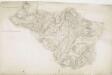
Capel Bettws
1 : 31680 Robert Dawson is author of this drawing, which shows west Wales from Carmarthenshire to Cardigan Bay. One of the best surveyors and draughtsmen, Dawson was employed on the Ordnance Survey for over forty years, also working as an instructor. Below the formal title of the plan, in the top left margin, is an area calculation in black ink. Brushwork interlinging ('hachuring') and colour washes depicting relief are combined with numerical annotations ('spot heights') describing the height of the land. Those altitudes noted in red ink are trigonometrically ascertained; those in black are estimated. Dawson, Robert
Hafod, Llanidloes
1 : 31680 .This plan of the,Ystwyth valley in the Cambrian Mountains is formally titled. The scale of the drawing is noted and the area of the land recorded,as 183.0453 square miles. Archaeological sites are named in gothic script. Colour washes depicting relief are combined with numerical annotations ('spot heights'), in red and black ink, indicating the height of the hills. The altitudes in red ink,are trigonometrically ascertained; those in black are estimated. Dawson, Robert
Llandovery(002OSD000000021U00147000)
1 : 31680 This plan of part of East Carmarthenshire and West Pembrokeshire shows the county border as a red line near the right margin of the sheet. A table above the plan gives trigonometrical data. Triangulation,lines in pencil are clearly visible outside the surveyed area. Colour washes are used to indicate relief, with numbers at the summit of inclines giving their altitude in feet. Dawson, Robert
![Ceretica; sive Cardiganensis Comitatus; Anglis Cardigan Shire. [Karte], in: Theatrum orbis terrarum, sive, Atlas novus, Bd. 4, S. 421.](https://images-2.georeferencer.com/images/iiif/230309355854/full/,300/0/native.jpg)

