Cataloged map
Carmarthen, Sheet 22 - Bartholomew's "Half Inch to the Mile Maps" of England & Wales
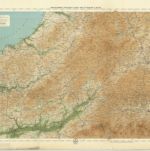

Full title:Carmarthen, Sheet 22 - Bartholomew's "Half Inch to the Mile Maps" of England & Wales
Depicted:1903
Pubdate:1903
Publisher:John Bartholomew & Co
Physical Size:20 x 30 cm
Map scale:1:126 720
An accurate map of Cardigan Shire
1754
Kitchin; Tinney
Ceretica; sive Cardiganensis comitatus; anglis Cardigan Shire
1646
Blaeu
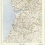
Aberystwyth - OS One-Inch Map
1952
Ordnance Survey
1:63k
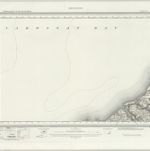
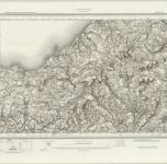
Aberaeron (Hills) - OS One-Inch Revised New Series
1897
Ordnance Survey
1:63k
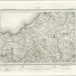
Aberaeron (Outline) - OS One-Inch Revised New Series
1897
Ordnance Survey
1:63k
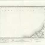
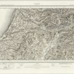
Llangranog (Hills) - OS One-Inch Revised New Series
1897
Ordnance Survey
1:63k
Llangranog (Outline) - OS One-Inch Revised New Series
1897
Ordnance Survey
1:63k
Llanilar (Hills) - OS One-Inch Revised New Series
1897
Ordnance Survey
1:63k
Llanilar (Outline) - OS One-Inch Revised New Series
1897
Ordnance Survey
1:63k
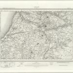
Lampeter (Hills) - OS One-Inch Revised New Series
1897
Ordnance Survey
1:63k
Lampeter (Outline) - OS One-Inch Revised New Series
1897
Ordnance Survey
1:63k