Maps of Ceredigion

Maps of Ceredigion

$title$

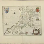
CERETICA; | sive | CARDIGANensis | Comitatus; Anglis | CARDIGAN SHIRE.

[Amsterdam : Joan Blaeu]
$title$

Ceretica, sive Cardiganensis Comitatus, anglis Cardigan Shire

1 : 460000 Amstelodami : apud Joannem Janssonium
$title$

An accurate map of Cardigan Shire

1 Karte : Kupferdruck ; 33 x 52 cm Kitchin; Tinney John Tinney
$title$

Ceretica; sive Cardiganensis comitatus; anglis Cardigan Shire

1 Karte : Kupferdruck ; 36 x 48 cm Blaeu Joan Blaeu
$title$

Sheets 29-30. (Cary's England, Wales, and Scotland).

1 : 360000 Cary, John, ca. 1754-1835
$title$

Carmarthen, Sheet 22 - Bartholomew's "Half Inch to the Mile Maps" of England & Wales

1 : 126720 Topographic maps Bartholomew, John George John Bartholomew & Co
$title$

South Wales and the border in the 14th century

Rees, William Ordnance Survey
$title$

Aberystwyth - OS One-Inch Map

1 : 63360 Topographic maps Ordnance Survey Ordnance Survey
$title$

Aberystwyth, Sheet 16 - Bartholomew's "Half Inch to the Mile Maps" of England & Wales

1 : 126720 Topographic maps Bartholomew, John George John Bartholomew & Co
$title$

An accurate map of Radnor Shire

1 Karte : Kupferdruck ; 33 x 51 cm Kitchin; Tinney John Tinney
$title$

Radnoria comitatvs

1 Karte : Kupferdruck ; 37 x 48 cm Blaeu Joan Blaeu
$title$

Radnoriensis Comitatus vulgo the counties of Radnor

1 : 180000 Amstelodami : apud Joannem Janssonium
$title$

RADNORIA | COMITATVS | RADNOR SHIRE.

[Amsterdam : Joan Blaeu]
$title$

Llandovery - OS One-Inch Map

1 : 63360 Topographic maps Ordnance Survey Ordnance Survey
$title$

Cardigan - OS One-Inch Map

1 : 63360 Topographic maps Ordnance Survey Ordnance Survey
$title$

Newcastle-in-Emlyn

1 : 31680 This plan of North Carmarthenshire shows the Teify Valley at the top, with settlements, enclosed farmland and densely wooded areas dominating the valley landscape. Mynydd Llanllwni and Pencarreg depicted at the bottom of the sheet form the valley's distinctive backdrop. Rising steeply from the valley, the rounded and open plateau summit of Mynydd Llanllwni contains extensive areas of moorland and common land, represented by open dots on the plan. Budgen, Thomas
$title$

Cardiganshire

1 : 31680 This drawing is formally titled. Its scale is noted and the surveyed area recorded as 205.6742 square miles. Archaeological sites are named in gothic script. Colour washes depicting relief are combined with numerical annotations ('spot heights') in red and black ink giving the heights of the hills. Figures in red represent trigonometrically ascertained altitudes whereas those in black are estimates. On the top left margin a note, dated 1st April 1822, from draughtsman Robert Dawson reads: "Cws yr ychen Bannog, is an ancient Bank said to run from sea to sea. It could not be traced in this survey beyond Carn Cron. The Rev John Williams of Ystrad Meyric supposes it may be a British Road, or a Boundary between two tribes of the Britons". Dawson, Robert
$title$

Lampeter

1 : 31680 This plan of Cardigan Bay and part of the county of Cardiganshire shows Lampeter and other settlements at lower left along the River Teify Valley. Pointed rocks below sharp cliffs, characteristic of the Cardiganshire coastline, are illustrated in elevation. Budgen, Thomas
$title$

Capel Bettws

1 : 31680 Robert Dawson is author of this drawing, which shows west Wales from Carmarthenshire to Cardigan Bay. One of the best surveyors and draughtsmen, Dawson was employed on the Ordnance Survey for over forty years, also working as an instructor. Below the formal title of the plan, in the top left margin, is an area calculation in black ink. Brushwork interlinging ('hachuring') and colour washes depicting relief are combined with numerical annotations ('spot heights') describing the height of the land. Those altitudes noted in red ink are trigonometrically ascertained; those in black are estimated. Dawson, Robert
$title$

Hafod, Llanidloes

1 : 31680 .This plan of the,Ystwyth valley in the Cambrian Mountains is formally titled. The scale of the drawing is noted and the area of the land recorded,as 183.0453 square miles. Archaeological sites are named in gothic script. Colour washes depicting relief are combined with numerical annotations ('spot heights'), in red and black ink, indicating the height of the hills. The altitudes in red ink,are trigonometrically ascertained; those in black are estimated. Dawson, Robert
$title$

Llandovery(002OSD000000021U00147000)

1 : 31680 This plan of part of East Carmarthenshire and West Pembrokeshire shows the county border as a red line near the right margin of the sheet. A table above the plan gives trigonometrical data. Triangulation,lines in pencil are clearly visible outside the surveyed area. Colour washes are used to indicate relief, with numbers at the summit of inclines giving their altitude in feet. Dawson, Robert
$title$

Builth

1 : 31680 These field sketches of the Irfon Valley in central Wales were made on several pieces of thin and irregularly cut paper, joined and laid down on thick paper. The assemblage was cut into 12 rectangular pieces, each approximately 200 x 310mm, then remounted to form one sheet. The many pencil notes on the drawing were made before the sheet was cut. The map provides a good illustration of the convention of 'relative command', which indicates the relative height of the hills using black ink numbers: Hill 3 being higher than Hill 2, for example. Brushwork interlining and ink washes further depict relief. Dawson, Robert
$title$

Cardigan

1 : 31680 This plan of part of Cardiganshire shows the county town on the,north bank of the,River Teify as it,enters Cardigan,Bay. Further inland, the landscape is dominated by moorland and the peaks of the Presely Mountains, represented by dense brushwork interlining ('hachuring'). The huge blue stones,that make up,the ancient ceremonial site of Stonehenge came from these mountains -,a journey of some 200 miles. Budgen, Thomas
$title$

Montgomery and Llandrindod Wells - OS One-Inch Map

1 : 63360 Topographic maps Ordnance Survey Ordnance Survey
$title$

Baulit

1 : 31680 The Wye Valley runs from the top to the bottom of the sheet.Forming a natural border, the valley became a regular battleground throughout the Roman, Saxon Norman eras,and during the Marcher Wars in the reign of James I. To the left of the sheet are the peaks of Mynydd Eppynt. To the right, the border of England and Wales is marked by the ancient earth bank, Offa's Dyke. The castle town of Builth is depicted at the top of the sheet. Built at the end of the 12th century, the castle witnessed repeated conflicts, and frequently changed hands between the Welsh and English. After Edward I's campaign against the Welsh in 1277, the castle was refortified and transformed into a formidable fortress. Budgen, Thomas
$title$

Llandrindod

1 : 31680 This plan of part of Powis,depicts the uplands of the Radnor Forest, to the right of the sheet. A mix of dispersed farmland and commonland,along the valley of the Ithon River dominates the landscape of this,central part of,Wales. Budgen, Thomas
$title$

Newtown

1 : 31680 The River Severn Valley,features,runs,from left to right on this plan of part of mid- Wales. With its source high on the Cumbrian Mountains, the river flows through,a narrow rocky channel in its upper course, becoming wider and deeper in its middle course and its valley flatter. Budgen, Thomas
$title$

Aberystwyth 13

1 : 31680 This plan of Cardigan Bay extends from Aberystwyth at the top left to Llansantffraid at the bottom left. A stretch of the Cambrian Mountains and the peat bogs of Cors-goch Glan Teifi are depicted further inland. The map's scale is noted beneath the formal title and the area of the land recorded as 117.8114 square miles. The circular hole in the top right-hand corner indicates that an 'Ordnance Office Copy' blind stamp has been removed from the sheet. Archaeological sites are named in gothic script. Colour washes depicting relief are combined with numerical annotations in black ink. Dawson, Robert
$title$

Aberaeron (Hills) - OS One-Inch Revised New Series

1 : 63360 Topographic maps Ordnance Survey Ordnance Survey
$title$

Aberaeron (Outline) - OS One-Inch Revised New Series

1 : 63360 Topographic maps Ordnance Survey Ordnance Survey
© MapTiler © OpenStreetMap contributors
How does it work?
These instructions will show you how to find historical maps online.
Getting started
Type the place name in the search box to find the exact location. You can further adjust the search by zooming in and out.
Zoom
Zoom in and out with the buttons or use your mouse or touchpad natively.
Exact Area tool
Click here and draw a rectangle over the map to precisely define the search area.
Set filters
Narrow your search with advanced settings, such as Years (from/to), Fulltext, Publisher, etc.
Results
See the results of your search on the right side. You can scroll down to find more maps of this location.
?

Download OldMapsOnline Mobile