Maps of Cambrian Mountains

RADNOR BREKNOK Cardigan et Caermarden
This map of Radnor,Cardigan, Carmarthenshire and Brecknonshire, from the 1583 edition of the Saxton atlas of England and Wales.This atlas was first published as a whole in 1579. It consists of 35 coloured maps depicting the counties of England and Wales. The atlas is of great significance to British cartography as it set a standard of cartographic representation in Britain and the maps remained the basis for English county mapping, with few exceptions, until after 1750. During the reign of Elizabeth I map use became more common, with many government matters referring to increasingly accurate maps with consistent scales and symbols, made possible by advances in surveying techniques. Illustrating the increasing used of maps in government matters, Lord Burghley, Elizabeth I’s Secretary of State, who had been determined to have England and Wales mapped in detail from the 1550s, selected the cartographer Christopher Saxton to produce a detailed and consistent survey of the country. The financier of the project was Thomas Seckford Master of Requests at the Court of Elizabeth I, whose arms appear, along with the royal crest, on each map. Saxton, Christopher Ryther, Augustine
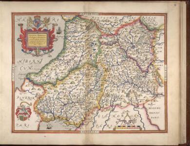
RADNOR, BREKNOK, Cardigan et Caermarden
This is a map of Radnor, Brecknock, Cardigan and Caermarthen by Christopher Saxton which dates from 1578. It forms part of an atlas that belonged to William Cecil Lord Burghley, Elizabeth I’s Secretary of State. Burghley used this atlas to illustrate domestic matters. This map is actually a proof copy of one which forms part of Christopher Saxton’s Atlas of England and Wales. This atlas was first published as a whole in 1579. It consists of 35 coloured maps depicting the counties of England and Wales. The atlas is of great significance to British cartography as it set a standard of cartographic representation in Britain and the maps remained the basis for English county mapping, with few exceptions, until after 1750. During the reign of Elizabeth I map use became more common, with many government matters referring to increasingly accurate maps with consistent scales and symbols, made possible by advances in surveying techniques. Illustrating the increasing use of maps in government matters, Lord Burghley, who had been determined to have England and Wales mapped in detail from the 1550s, selected the cartographer Christopher Saxton to produce a detailed and consistent survey of the country. The financier of the project was Thomas Seckford, Master of Requests at the Court of Elizabeth I, whose arms appear, along with the royal crest, on each map. Burghley has annotated this map, adding place names. At this time England was under threat of invasion from Catholic Spain, a threat which culminated in the events of the Spanish Armada. Defence of the realm depended on a good geographic and topographic knowledge, explaining Burghley's use of maps and his annotation of them. The map was engraved by one of a team of seven English and Flemish engravers employed to produce the copper plates for the atlas, although the individual engraver is not noted. Saxton, Christopher William Cecil, Lord Burghley
England and Wales 1:253,440
Ordnance Survey
Ceretica; sive Cardiganensis Comitatus; Anglis Cardigan Shire. [Karte], in: Le théâtre du monde, ou, Nouvel atlas contenant les chartes et descriptions de tous les païs de la terre, Bd. 4, S. 363.
1 Karte aus Atlas Blaeu, Willem Janszoon und Blaeu, Joan Blaeu, Willem Janszoon
Ceretica; sive Cardiganensis Comitatus; Anglis Cardigan Shire. [Karte], in: Novus atlas absolutissimus, Bd. 7, S. 395.
1 Karte aus Atlas Janssonius Offizin
Ceretica; sive Cardiganensis Comitatus; Anglis Cardigan Shire. [Karte], in: Theatrum orbis terrarum, sive, Atlas novus, Bd. 4, S. 421.
1 Karte aus Atlas Blaeu, Joan Blaeu, Willem Janszoon
Ceretica; sive Cardiganensis Comitatus; Anglis Cardigan Shire. [Karte], in: Theatrum orbis terrarum, sive, Atlas novus, Bd. 4, S. 421.
1 Karte aus Atlas Blaeu, Joan Blaeu, Willem Janszoon
CERETICA; | sive | CARDIGANensis | Comitatus; Anglis | CARDIGAN SHIRE.
[Amsterdam : Joan Blaeu]
Ceretica, sive Cardiganensis Comitatus, anglis Cardigan Shire
1 : 460000 Amstelodami : apud Joannem Janssonium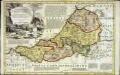
An accurate map of Cardigan Shire
1 Karte : Kupferdruck ; 33 x 52 cm Kitchin; Tinney John Tinney
Ceretica; sive Cardiganensis comitatus; anglis Cardigan Shire
1 Karte : Kupferdruck ; 36 x 48 cm Blaeu Joan Blaeu
Penbrochia Comitatus et Comitatus Caermaridunum. [Karte], in: Le théâtre du monde, ou, Nouvel atlas contenant les chartes et descriptions de tous les païs de la terre, Bd. 4, S. 358.
1 Karte aus Atlas Blaeu, Willem Janszoon und Blaeu, Joan Blaeu, Willem Janszoon
Comitatus Brechiniae; Breknoke. [Karte], in: Theatrum orbis terrarum, sive, Atlas novus, Bd. 4, S. 401.
1 Karte aus Atlas Blaeu, Joan Blaeu, Willem Janszoon
Penbrochia Comitatus et Comitatus Caermaridunum. [Karte], in: Theatrum orbis terrarum, sive, Atlas novus, Bd. 4, S. 414.
1 Karte aus Atlas Blaeu, Joan Blaeu, Willem Janszoon
Penbrochia Comitatus et Comitatus Caermaridunum. [Karte], in: Theatrum orbis terrarum, sive, Atlas novus, Bd. 4, S. 414.
1 Karte aus Atlas Blaeu, Joan Blaeu, Willem Janszoon
Comitatus Brechiniae; Breknoke. [Karte], in: Theatrum orbis terrarum, sive, Atlas novus, Bd. 4, S. 401.
1 Karte aus Atlas Blaeu, Joan Blaeu, Willem Janszoon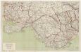
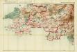
[Kaart], uit: South Wales / produced & publ. by Geographia
1 : 125703 titelvariant: Geographia road map of South Wales; Annotatie: Titel op omslag: Geographia road map of South Wales Geographia, London London : Geographia
Comitatus Brechiniae; Breknoke. [Karte], in: Le théâtre du monde, ou, Nouvel atlas contenant les chartes et descriptions de tous les païs de la terre, Bd. 4, S. 347.
1 Karte aus Atlas Blaeu, Willem Janszoon und Blaeu, Joan Blaeu, Willem Janszoon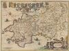
Penbrochia Comitatus et Comitatus Caermardinum. [Karte], in: Novus atlas absolutissimus, Bd. 7, S. 388.
1 Karte aus Atlas Janssonius Offizin
Carmarthen, Sheet 22 - Bartholomew's "Half Inch to the Mile Maps" of England & Wales
1 : 126720 Topographic maps Bartholomew, John George John Bartholomew & Co
COMITATVS | BRECHNIÆ; | BREKNOKE.
[Amsterdam : Joan Blaeu]
PENBROCHIA | Comitatus et Comitatus | CAERMARIDVNVM.
[Amsterdam : Joan Blaeu]
Penbrochia Comitatus et Comitatus Caermardinum
1 : 230000 Amstelodami : apud Joannem Janssonium
Sheets 29-30. (Cary's England, Wales, and Scotland).
1 : 360000 Cary, John, ca. 1754-1835
Radnoriensis Comitatus Vulgo The Countie of Radnor. [Karte], in: Novus atlas absolutissimus, Bd. 7, S. 381.
1 Karte aus Atlas Janssonius Offizin
Radnoria Comitatus Radnor Shire. [Karte], in: Theatrum orbis terrarum, sive, Atlas novus, Bd. 4, S. 398.
1 Karte aus Atlas Blaeu, Joan Blaeu, Willem Janszoon
Radnoria Comitatus Radnor Shire. [Karte], in: Le théâtre du monde, ou, Nouvel atlas contenant les chartes et descriptions de tous les païs de la terre, Bd. 4, S. 344.
1 Karte aus Atlas Blaeu, Willem Janszoon und Blaeu, Joan Blaeu, Willem Janszoon
Radnoria Comitatus Radnor Shire. [Karte], in: Theatrum orbis terrarum, sive, Atlas novus, Bd. 4, S. 398.
1 Karte aus Atlas Blaeu, Joan Blaeu, Willem Janszoon
Penbrochia comitatus et comitatus Caermaridvnvm
1 Karte : Kupferdruck ; 39 x 51 cm Blaeu Joan Blaeu