Maps of Monmouthshire

Comitatus Brechiniae; Breknoke. [Karte], in: Theatrum orbis terrarum, sive, Atlas novus, Bd. 4, S. 401.
1 Karte aus Atlas Blaeu, Joan Blaeu, Willem Janszoon
Comitatus Brechiniae; Breknoke. [Karte], in: Le théâtre du monde, ou, Nouvel atlas contenant les chartes et descriptions de tous les païs de la terre, Bd. 4, S. 347.
1 Karte aus Atlas Blaeu, Willem Janszoon und Blaeu, Joan Blaeu, Willem Janszoon
Comitatus Brechiniae; Breknoke. [Karte], in: Theatrum orbis terrarum, sive, Atlas novus, Bd. 4, S. 401.
1 Karte aus Atlas Blaeu, Joan Blaeu, Willem Janszoon
COMITATVS | BRECHNIÆ; | BREKNOKE.
[Amsterdam : Joan Blaeu]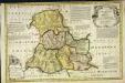
An accurate map of Brecknock Shire
1 Karte : Kupferdruck ; 33 x 50 cm Kitchin; Tinney sold by I. Tinney at the Golden Lion in Fleet street
Comitatvs Brechiniæ
1 Karte : Kupferdruck ; 36 x 49 cm Blaeu Joan Blaeu
Brecon - OS One-Inch Map
1 : 63360 Topographic maps Ordnance Survey Ordnance Survey
Radnoria Comitatus Radnor Shire. [Karte], in: Theatrum orbis terrarum, sive, Atlas novus, Bd. 4, S. 398.
1 Karte aus Atlas Blaeu, Joan Blaeu, Willem Janszoon
Radnoria Comitatus Radnor Shire. [Karte], in: Theatrum orbis terrarum, sive, Atlas novus, Bd. 4, S. 398.
1 Karte aus Atlas Blaeu, Joan Blaeu, Willem Janszoon
Radnoria Comitatus Radnor Shire. [Karte], in: Le théâtre du monde, ou, Nouvel atlas contenant les chartes et descriptions de tous les païs de la terre, Bd. 4, S. 344.
1 Karte aus Atlas Blaeu, Willem Janszoon und Blaeu, Joan Blaeu, Willem Janszoon
Radnoriensis Comitatus Vulgo The Countie of Radnor. [Karte], in: Novus atlas absolutissimus, Bd. 7, S. 381.
1 Karte aus Atlas Janssonius Offizin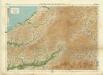
Carmarthen, Sheet 22 - Bartholomew's "Half Inch to the Mile Maps" of England & Wales
1 : 126720 Topographic maps Bartholomew, John George John Bartholomew & Co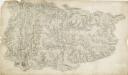
Baulit
1 : 31680 The Wye Valley runs from the top to the bottom of the sheet.Forming a natural border, the valley became a regular battleground throughout the Roman, Saxon Norman eras,and during the Marcher Wars in the reign of James I. To the left of the sheet are the peaks of Mynydd Eppynt. To the right, the border of England and Wales is marked by the ancient earth bank, Offa's Dyke. The castle town of Builth is depicted at the top of the sheet. Built at the end of the 12th century, the castle witnessed repeated conflicts, and frequently changed hands between the Welsh and English. After Edward I's campaign against the Welsh in 1277, the castle was refortified and transformed into a formidable fortress. Budgen, Thomas
Radnoriensis Comitatus vulgo the counties of Radnor
1 : 180000 Amstelodami : apud Joannem Janssonium
RADNORIA | COMITATVS | RADNOR SHIRE.
[Amsterdam : Joan Blaeu]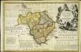
An accurate map of Radnor Shire
1 Karte : Kupferdruck ; 33 x 51 cm Kitchin; Tinney John Tinney
Radnoria comitatvs
1 Karte : Kupferdruck ; 37 x 48 cm Blaeu Joan Blaeu
Llandovery - OS One-Inch Map
1 : 63360 Topographic maps Ordnance Survey Ordnance Survey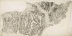
Abergavenny
1 : 31680 This plan of part of Monmouthshire shows the valley of the River Usk running from top to bottom of the sheet, with the Abergavenny canal (used to carry a small trade up to Breconshire) following the course of the river. To the left of the plan, the Welsh valleys stretch down the coastal plain from the Brecon Beacons to the cities of Cardiff, Swansea and Newport. Rich in iron ore, coal and limestone, the valleys developed from rural to industrial communities during the course of the 18th century. Highlighted in red along the mines and ironworks of the valleys are tramroads, the horse-worked railways predating the age of steam. Budgen, Charles
Cardiganshire
1 : 31680 This drawing is formally titled. Its scale is noted and the surveyed area recorded as 205.6742 square miles. Archaeological sites are named in gothic script. Colour washes depicting relief are combined with numerical annotations ('spot heights') in red and black ink giving the heights of the hills. Figures in red represent trigonometrically ascertained altitudes whereas those in black are estimates. On the top left margin a note, dated 1st April 1822, from draughtsman Robert Dawson reads: "Cws yr ychen Bannog, is an ancient Bank said to run from sea to sea. It could not be traced in this survey beyond Carn Cron. The Rev John Williams of Ystrad Meyric supposes it may be a British Road, or a Boundary between two tribes of the Britons". Dawson, Robert
Hay
1 : 31680 Pencil lines radiating from fixed points indicate trigonometric measurements made to plot features of the landscape. These are particularly evident at the margins of the drawing, where they are annotated by place names. Budgen
Llandovery(002OSD000000021U00146000)
1 : 31680 Towy Valley, the major historic route into west Wales, is depicted at the top of the plan, with a section of the ancient Roman road from Llandovery to Landilo Fawr. Near the bottom of the sheet, dense brushwork is used to describe the peaks of the Black Mountains. Budgen, Thomas
Llandovery(002OSD000000021U00147000)
1 : 31680 This plan of part of East Carmarthenshire and West Pembrokeshire shows the county border as a red line near the right margin of the sheet. A table above the plan gives trigonometrical data. Triangulation,lines in pencil are clearly visible outside the surveyed area. Colour washes are used to indicate relief, with numbers at the summit of inclines giving their altitude in feet. Dawson, Robert
Builth
1 : 31680 These field sketches of the Irfon Valley in central Wales were made on several pieces of thin and irregularly cut paper, joined and laid down on thick paper. The assemblage was cut into 12 rectangular pieces, each approximately 200 x 310mm, then remounted to form one sheet. The many pencil notes on the drawing were made before the sheet was cut. The map provides a good illustration of the convention of 'relative command', which indicates the relative height of the hills using black ink numbers: Hill 3 being higher than Hill 2, for example. Brushwork interlining and ink washes further depict relief. Dawson, Robert
Llandovery 3
1 : 31680 .The Black Mountains dominate this plan of part of,Carmarthenshire, with the toll road from London to Haverfordwest and the Pembrokeshire coast forming the northern boundary. Above the plan, Brynda is indicated as a reference point for triangulation. Near the bottom right, the remains of an old Roman road across the Fawr Forest are indicated by a red double-dotted line. Budgen, Thomas
Builth (Hills) - OS One-Inch Revised New Series
1 : 63360 Topographic maps Ordnance Survey Ordnance Survey
Builth (Outline) - OS One-Inch Revised New Series
1 : 63360 Topographic maps Ordnance Survey Ordnance Survey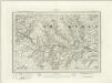
Brecon (Outline) - OS One-Inch Revised New Series
1 : 63360 Topographic maps Ordnance Survey Ordnance Survey
Brecon (Hills) - OS One-Inch Revised New Series
1 : 63360 Topographic maps Ordnance Survey Ordnance Survey
Merthyr Tydfil (Hills) - OS One-Inch Revised New Series
1 : 63360 Topographic maps Ordnance Survey Ordnance Survey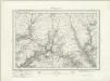
![Comitatus Brechiniae; Breknoke. [Karte], in: Theatrum orbis terrarum, sive, Atlas novus, Bd. 4, S. 401.](https://images-2.georeferencer.com/images/iiif/464323184746/full/,300/0/native.jpg)

